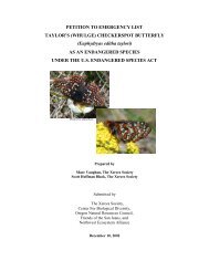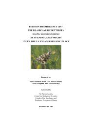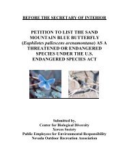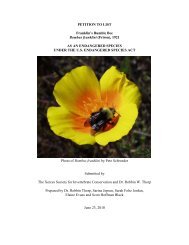
Outline of Quino Recovery Plan - The Xerces Society
Outline of Quino Recovery Plan - The Xerces Society
Outline of Quino Recovery Plan - The Xerces Society

Create successful ePaper yourself
Turn your PDF publications into a flip-book with our unique Google optimized e-Paper software.
development. Protection <strong>of</strong> undeveloped areas along the eastern Otay Lake<br />
margin and within the habitat patches east <strong>of</strong> the lake are necessary for continued<br />
occupancy <strong>of</strong> nearby habitat patches (see Lake Hodges and Dictionary Hill<br />
discussion above). Habitat patches northeast <strong>of</strong> the lakes are still well connected.<br />
Landscape connectivity along the western margin <strong>of</strong> Otay Lake is constrained by<br />
the Olympic Training Center and other development, although some habitat<br />
remains along the Salt Creek drainage. Landscape connectivity on the eastern<br />
margin <strong>of</strong> Otay Lake is constrained by stands <strong>of</strong> woodland vegetation dominated<br />
by nonnative species. Historic records indicate that habitat (now in the San<br />
Diego National Wildlife Refuge) near Sweetwater River was, and appears to still<br />
be, connected to Proctor Valley, San Miguel Mountain, and thus to currently<br />
occupied habitat around Otay Lakes (Figure 2). Landscape connectivity on the<br />
mesas northeast <strong>of</strong> Brown Field and southwest <strong>of</strong> lower Otay Lake is reduced,<br />
although no significant dispersal barriers exist. <strong>The</strong>refore landscape connectivity<br />
could be restored where distance between habitat patches is now too great to<br />
provide adequate linkage. Mesa top habitats along the northern margin <strong>of</strong> Otay<br />
Mesa can also possibly be reconnected. Soils in the area that are most <strong>of</strong>ten<br />
observed to support <strong>Quino</strong> checkerspots are red or gray colored clay. Dwarf<br />
plantain (<strong>Plan</strong>tago erecta) is the primary host plant found in this area.<br />
Jacumba Peak habitat complex: Recent <strong>Quino</strong> checkerspot observations are<br />
concentrated northwest <strong>of</strong> the community <strong>of</strong> Jacumba (Figure 2). Sites in<br />
Jacumba and El Condor in Baja California, Mexico (see below) are about 6<br />
kilometers (4 miles) apart.<br />
Current habitat and landscape connectivity in the Jacumba area are relatively<br />
intact. A historic butterfly record occurs north <strong>of</strong> Interstate 8 in the Table<br />
Mountain area (Figure 2). <strong>The</strong> Table Mountain site and apparently suitable<br />
surrounding habitat areas (G. Pratt, pers. comm.) are within the Jacumba<br />
National Cooperative Land and Wildlife Management Area, therefore no habitat<br />
fragmentation or constraining <strong>of</strong> landscape connectivity has occurred or is likely<br />
to occur in that area. Landscape connectivity between Table Mountain and<br />
Jacumba Peak is constrained by Interstate 8. However, connectivity likely exists<br />
between the Jacumba Peak habitat complex and El Condor in Baja California,<br />
Mexico. Although degraded by grazing in some areas, apparently suitable<br />
habitat also exists in the vicinity <strong>of</strong> McCain Valley. Habitat patches containing<br />
15