5: victorian villages - The Royal Borough of Windsor and Maidenhead
5: victorian villages - The Royal Borough of Windsor and Maidenhead
5: victorian villages - The Royal Borough of Windsor and Maidenhead

Create successful ePaper yourself
Turn your PDF publications into a flip-book with our unique Google optimized e-Paper software.
A. DESCRIPTION<br />
Location/distribution <strong>of</strong> type<br />
Inter War Suburbs are distributed throughout<br />
the <strong>Royal</strong> <strong>Borough</strong>, <strong>of</strong>ten adjacent to the<br />
Victorian Suburbs or Villages. Large scale<br />
inter-war estates are seen in the settlements<br />
<strong>of</strong> <strong>Windsor</strong> <strong>and</strong> <strong>Maidenhead</strong>, with smaller<br />
pockets <strong>of</strong> interwar development in smaller<br />
settlements such as Datchet <strong>and</strong> Cookham<br />
Rise.<br />
Stationery Office, Crown Copyright, Licence Number<br />
10001926.<br />
Townscape Character<br />
L<strong>and</strong> Use/Image<br />
L<strong>and</strong> use is predominantly residential, but<br />
the suburbs include schools built in the same<br />
period, <strong>and</strong> associated open spaces such as<br />
recreation grounds <strong>and</strong> allotments.<br />
Physical Influences<br />
<strong>The</strong> underlying geology <strong>and</strong> soils do not<br />
generally influence the character <strong>of</strong> the<br />
townscape due to the ornamental nature <strong>of</strong><br />
the planting. Topography underlying these<br />
suburbs tends to be flat or gently undulating<br />
<strong>and</strong> therefore does not noticeably influence<br />
the layout <strong>of</strong> roads or building.<br />
Human Influences<br />
<strong>The</strong> interwar suburbs grew rapidly, probably<br />
in no more than 20 years from the end <strong>of</strong><br />
the First World War, resulting in<br />
considerable stylistic <strong>and</strong> visual unity. <strong>The</strong>re<br />
is very little evidence <strong>of</strong> the earlier cultural<br />
pattern or l<strong>and</strong> use.<br />
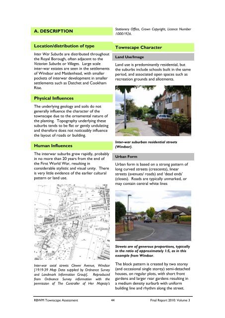
Inter-war suburban residential streets<br />
(<strong>Windsor</strong>).<br />
Urban Form<br />
Urban form is based on a strong pattern <strong>of</strong><br />
long curved streets (crescents), linear<br />
streets (avenues/ roads) <strong>and</strong> ‘dead ends’<br />
(closes). Roads are typically unmarked, or<br />
may contain central white lines<br />
Streets are <strong>of</strong> generous proportions, typically<br />
in the ratio <strong>of</strong> approximately 1:5, as in this<br />
example from <strong>Windsor</strong>.<br />
Inter-war axial streets Clewer Avenue, <strong>Windsor</strong><br />
[1919-39 Map Data supplied by Ordnance Survey<br />
<strong>and</strong> L<strong>and</strong>mark Information Group]. Reproduced<br />
from Ordnance Survey information with the<br />
permission <strong>of</strong> <strong>The</strong> Controller <strong>of</strong> Her Majesty’s<br />
<strong>The</strong> block pattern is created by two storey<br />
(<strong>and</strong> occasional single storey) semi-detached<br />
houses, on regular plots, with short front<br />
gardens <strong>and</strong> larger rear gardens resulting in<br />
a medium density surburb with uniform<br />
building line <strong>and</strong> rhythm along the street.<br />
RBWM Townscape Assessment 44 Final Report 2010: Volume 3