5: victorian villages - The Royal Borough of Windsor and Maidenhead
5: victorian villages - The Royal Borough of Windsor and Maidenhead
5: victorian villages - The Royal Borough of Windsor and Maidenhead

You also want an ePaper? Increase the reach of your titles
YUMPU automatically turns print PDFs into web optimized ePapers that Google loves.
including lodges with large gardens (which may have originally been built to serve larger<br />
houses in the area). Gate houses or gate lodges provide interest within Sunningdale,<br />
especially where they terminate vistas along streets (such as Church Road). <strong>The</strong> special<br />
architectural <strong>and</strong> historic interest <strong>of</strong> this area is recognised through its designation as part <strong>of</strong><br />
Sunningdale Conservation Area.<br />
All <strong>of</strong> the guidance above applies to this area. In particular, ensure that changes (e.g. to<br />
building massing <strong>and</strong> scale, ro<strong>of</strong>scape <strong>and</strong> pitches, or relationship <strong>of</strong> buildings to space) do<br />
not detract from Holy Trinity Church as a l<strong>and</strong>mark. Maintain Holy Trinity primary school<br />
<strong>and</strong> the Baptist Church as local focus points in the village. Ensure the historic gateway at<br />
Holy Trinity Church remains as a node <strong>and</strong> key ‘arrival’ point into Old Sunningdale.<br />
Consider key views within the village when planning new development - ensure that Holy<br />
Trinity Church remains a focus in westerly views from Bedford Lane <strong>and</strong> easterly views<br />
Church Road. Conserve the wooded setting <strong>of</strong> the village <strong>and</strong> maintain visual seek links to<br />
surround parkl<strong>and</strong> – ensure any changes respect the setting <strong>of</strong> Sunningdale historic park. In<br />
addition, refer to any guidance written for the Sunningdale Conservation Area Statement.<br />
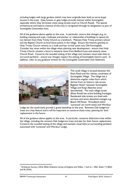
5F: Rises Road Victorian Village, Sunningdale<br />
This small village is located between the<br />
Rises Road <strong>and</strong> the railway, southwest <strong>of</strong><br />
Sunningdale Village. <strong>The</strong> village has a<br />
distinctive angular urban form which<br />
derives from an historic ride across<br />
Bagshot Heath 1 between Sunningdale<br />
Village <strong>and</strong> King’s Beeches (now<br />
demolished). <strong>The</strong> main village street<br />
(Rises Road) has active building frontages.<br />
Residential side streets are lined with<br />
terraces <strong>and</strong> semis detached cottages e.g.<br />
Beech Hill Road. Woodl<strong>and</strong> within<br />
‘Lynwood’ (to north-west) <strong>and</strong> Wardour<br />
Lodge (to the south-east) provide a green backdrop to the area. Remnant Oak hedgerow<br />
trees are a key feature <strong>and</strong> it will be important to conserve these trees, planning for their<br />
replacement in the future.<br />
All <strong>of</strong> the guidance above applies to this area. In particular, conserve distinctive trees within<br />
the village, including the remnant Oak hedgerow trees <strong>and</strong> plan for their future replacement.<br />
Conserve the wooded setting <strong>of</strong> the village <strong>and</strong> maintain visual links to surrounding parkl<strong>and</strong><br />
associated with ‘Lynwood’ <strong>and</strong> Wardour Lodge.<br />
1<br />
Ordnance Survey (1816-1822) Ordnance Survey <strong>of</strong> Engl<strong>and</strong> <strong>and</strong> Wales, 1 Inch to 1 Mile, Sheet 7 (1822)<br />
<strong>and</strong> 8 (1816).<br />
RBWM Townscape Assessment 41 Final Report 2010: Volume 3