Part I
Part I
Part I

Create successful ePaper yourself
Turn your PDF publications into a flip-book with our unique Google optimized e-Paper software.
Draft Black Sea Regional Transmission Project ESIA<br />
<br />
<br />
<br />
<br />
Earthworks and rock excavation including dewatering if required, filling and<br />
grading and paving as needed.<br />
Steel structures.<br />
Foundations for substation control building and structures.<br />
Infrastructure works such as perimeter fencing, access and service roads and<br />
paths, water supply, storm drainage, cable ducts/trenches, doors and windows,<br />
and finishing work including masonry, plastering, filing, and painting.<br />
Design and execution will be based on applicable international regulations and standards in<br />
conjunction with Georgia norms and standards. The existing substations at Zestaphoni and<br />
Gardabani will be extended slightly to accommodate the new 500kV circuits at each location.<br />
This will require minimal additional land space since most of the new equipment will be<br />
installed within the existing substations.<br />
2.1.2 Transmission Lines<br />
As mentioned previously, a transmission line has been planned on the same proposed route<br />
from Gardabani to Zestaphoni since the late 1980s. Activities including right-of-way<br />
acquisition, land clearing, construction of foundations and construction of towers were<br />
conducted between 1989 and 1991 along about 65 percent of this route. As noted above,<br />
many of these towers have been damaged or completely removed by scavengers and many<br />
foundations are in precarious condition.<br />
The segments of the transmission line include:<br />
<br />
<br />
<br />
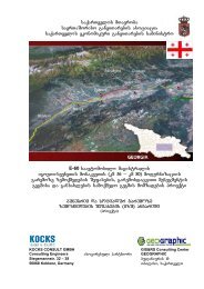
Segment 1 - Gardabani to Akhaltsikhe. Right-of-way acquisition, land-clearing, and<br />
tower construction were completed along 114.8 kilometers of this 187.5-kilometer<br />
route (61 percent) in three main areas as shown on Figure 2-1: from kilometer 0 at<br />
Gardabani to kilometer 40.4 west of Marneuli (40.4 kilometers); from kilometer 53.9<br />
east of Tetri-Tskaro to kilometer 99.5 near Tsalka (45.6 kilometers); and from<br />
kilometer 158.9 near Alastani to kilometer 187.5 (28.8 kilometers) at the proposed<br />
Akhaltsikhe substation. 1<br />
Segment 2 – Akhaltsikhe to Zestaphoni. Right-of-way acquisition, land-clearing, and<br />
tower construction were completed along 48.0 of this 61.1-kilometer route (79<br />
percent) in two main areas as shown on Figure 2-1: from kilometer 187.5 at the<br />
proposed Akhaltsikhe substation to kilometer 197.8 (10.3 kilometers) just inside the<br />
southern boundary of what is now Borjomi-Karagauli National Park; and from<br />
kilometer 210.9 just outside the northern boundary of the Borjomi-Karagauli National<br />
Park to kilometer 248.6 at the Zestaphoni substation (37.7 kilometers). Additionally,<br />
the right-of-way that connects these two segments through the National Park was<br />
initially cleared but has since largely re-grown. Remnants of some of the access<br />
roads are still present through these areas and are used as a local access route for<br />
recreational activities such as hiking and horseback riding.<br />
Segment 3 - Akhaltsikhe to Borchka (terminating near Vale on the Turkish Border).<br />
No activities have previously occurred on this segment, so this will be all new<br />
construction.<br />
1 The distance in kilometers is measured from the origin at the Gardabani substation.<br />
14