Part I
Part I
Part I

You also want an ePaper? Increase the reach of your titles
YUMPU automatically turns print PDFs into web optimized ePapers that Google loves.
Draft Black Sea Regional Transmission Project ESIA<br />
4.0 BASELINE ENVIRONMENTAL AND SOCIOECONOMIC CONDITIONS<br />
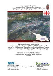
This chapter describes existing conditions in the districts along the transmission line route.<br />
Section 4.1 describes various environmental conditions, and section 4.2 describes<br />
socioeconomic conditions. Figure 4.0-1 provides an overview of major features along the<br />
transmission line route.<br />
4.1 Environmental Baseline<br />
4.1.1 Meteorology and Climate<br />
Overview. The climate in Georgia is diverse, with two distinctive climatic zones: humid<br />
subtropical in the west of the country and dry subtropical transiting to continental in the east.<br />
The Greater Caucasus Range plays an important role in the climatic regime, preventing<br />
intrusion of cold air from the north and producing a warmer regime with a small number of<br />
extreme meteorological events. Another significant factor in climate formation is the Black<br />
Sea in the west, which contributes to increased humidity in western Georgia. This influence<br />
is softened toward eastern Georgia by the natural barrier of the Surami and the Adjara-<br />
Traleti Ranges. Since humid air masses predominantly transfer from west to east,<br />
orographic lifting makes excessive moisture precipitate on the west slopes of these<br />
mountains. Consequently, the eastern side of the mountain ranges experience lower<br />
precipitation and lower relative humidity, resulting in a transition to a dry-subtropical climate<br />
eastwards, which are also affected by the dry plains of Azerbaijan.<br />
Climate along the route may be further sub-divided into several climatic regions, mainly<br />
owing to the different relief features, large variation of altitude, and proximity to the Black<br />
Sea. These subregions, beginning from the east at Gardabani, include:<br />
<br />
<br />
<br />
<br />
<br />
Dry-subtropical climate with warm summers (> 22°C) and mild winters<br />
(approximately 0 to -3°C) in the west near the Azerbaijan-Georgia border. It is<br />
characterized by a notably warmer and drier climate compared to the rest of the<br />
route. The climate becomes increasingly humid as the pipeline route approaches<br />
the Bedeni Plateau.<br />
A transitional climate between the dry-subtropical in the east, and the humidsubtropical<br />
mountainous steppe climate to the west, over the area spreading from<br />
the Bedeni Plateau to the feet of the Trialeti Range. Altitude gradually increases<br />
by approximately 800 meters over a short distance, which causes lower<br />
temperatures and higher wind speeds. Generally, the region experiences cold<br />
and occasionally snowy winters, and long mild summers. Precipitation along this<br />
section is the highest along the route.<br />
The humid-subtropical mountainous climate with cold winter ( 20°C). The climate is similar to the transient<br />
climatic zone, spread over the area between the Trialeti and the Samsari<br />
Mountain Ranges, though more moderate due to lower elevation and proximity to<br />
the Black Sea.<br />
A very humid subtropical warmer climate after crossing the Meskheti Range to<br />
Zestaphoni, when the route transits to the Western Georgia. The climate of the<br />
region is dominated by influences of the Black Sea and mountainous relief.<br />
33