Part I
Part I
Part I

You also want an ePaper? Increase the reach of your titles
YUMPU automatically turns print PDFs into web optimized ePapers that Google loves.
Draft Black Sea Regional Transmission Project ESIA<br />
1500 20<br />
1300<br />
15<br />
1100<br />
900<br />
10<br />
700<br />
500 5<br />
300<br />
0<br />
-5<br />
Gardabani Gardabani<br />
Marneuli Margneuli<br />
Tetritskaro Tetritskaro<br />
Tsalka Tsalka<br />
Akhalkalaki Akhalkalaki<br />
Aspindza Aspindza<br />
Akhaltsikhe<br />
Akhaltsikhe<br />
Baghdati<br />
Baghdati<br />
Zestafoni<br />
Zestafoni<br />
500<br />
45025<br />
400<br />
35020<br />
300<br />
25015<br />
200<br />
150 10<br />
10 0<br />
505<br />
0<br />
0<br />
-5<br />
-10<br />
Annual Average Precipitation (mm)<br />
Seasonal Precipitation (mm)<br />
Aver. Wint Aver. Spring<br />
Aver. Annual<br />
Aver. Min<br />
Aver. Max<br />
Aver. Summer Aver. Autumn<br />
Figure 4.1-3. Precipitation Profile along Transmission Line<br />
Multiyear Average Annual Temperature, (east °C to west Multiyear = left to Seasonal right) Average Temperature, °C<br />
Gardabani Gardabani<br />
Margneuli Margneuli<br />
Tetritskaro Tetritskaro<br />
Tsalka Tsalka<br />
Akhalkalaki Akhalkalaki<br />
Aspindza<br />
Aspindza<br />
Akhaltsikhe<br />
Akhaltsikhe<br />
Baghdati<br />
Baghdati<br />
Zestafoni<br />
Zestafoni<br />
Winter Spring Summer Autumn<br />
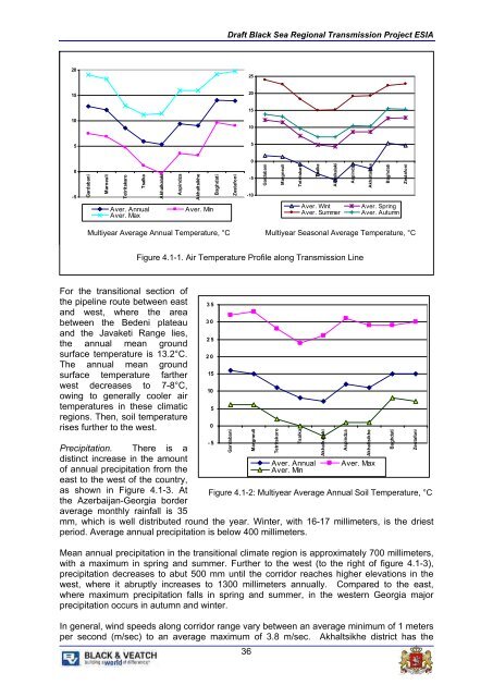
Figure 4.1-1. Air Temperature Profile along Transmission Line<br />
For the transitional section of<br />
the pipeline route between east<br />
and west, where the area<br />
between the Bedeni plateau<br />
and the Javaketi Range lies,<br />
the annual mean ground<br />
surface temperature is 13.2°C.<br />
The annual mean ground<br />
surface temperature farther<br />
west decreases to 7-8°C,<br />
owing to generally cooler air<br />
temperatures in these climatic<br />
regions. Then, soil temperature<br />
rises further to the west.<br />
35<br />
30<br />
25<br />
20<br />
15<br />
10<br />
5<br />
0<br />
-5<br />
Gardabani<br />
Precipitation. There is a<br />
distinct increase in the amount<br />
Aver. Annual Aver. Max<br />
of annual precipitation from the<br />
Aver. Min<br />
east to the west of the country,<br />
as shown in Figure 4.1-3. At Figure 4.1-2: Multiyear Average Annual Soil Temperature, °C<br />
the Azerbaijan-Georgia border<br />
average monthly rainfall is 35<br />
mm, which is well distributed round the year. Winter, with 16-17 millimeters, is the driest<br />
period. Average annual precipitation is below 400 millimeters.<br />
Mean annual precipitation in the transitional climate region is approximately 700 millimeters,<br />
with a maximum in spring and summer. Further to the west (to the right of figure 4.1-3),<br />
precipitation decreases to abut 500 mm until the corridor reaches higher elevations in the<br />
west, where it abruptly increases to 1300 millimeters annually. Compared to the east,<br />
where maximum precipitation falls in spring and summer, in the western Georgia major<br />
precipitation occurs in autumn and winter.<br />
In general, wind speeds along corridor range vary between an average minimum of 1 meters<br />
per second (m/sec) to an average maximum of 3.8 m/sec. Akhaltsikhe district has the<br />
36<br />
Margneuli<br />
Tetritskaro<br />
Tsalka<br />
Akhalkalaki<br />
Aspindza<br />
Akhaltsikhe<br />
Baghdati<br />
Zestafoni