USER MANUAL - ViaMichelin
USER MANUAL - ViaMichelin
USER MANUAL - ViaMichelin

Create successful ePaper yourself
Turn your PDF publications into a flip-book with our unique Google optimized e-Paper software.
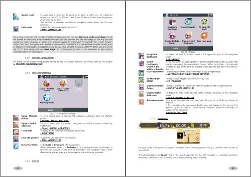
Bypass routeSave routeTo recalculate a route and to avoid an accident, a traffic jam, an unplanneddetour, etc. for 100 m, 500 m, 1 km, 5 km, 10 km or 20 km from the positiondetermined by the GPS.This function is activated uniquely in Navigation mode when the GPS wasinitialised.To save the route underway in the section> MON VIAMICHELINFor a route comprised of a number of different stages, you can click on “Move on to the next stage” to tellthe system to recalculate a new itinerary between the GPS position and the next stage. In this way you canchange the route to bypass a nearby town without leaving the main road. For example: for a route betweenSoisson and Sens, the system will calculate a route on the Francilienne. It is also possible to enter a route pointat Châlons-en-Champagne to establish a new itinerary that uses the motorway A26/E17. When you are on theA4 / E17 / E50, simply click on “Next stage” to continue your journey on the motorway to Sens withoutentering Châlons-en-Champagne.7.1.3. SECURITY CONFIGURATIONFor details on the safety configurations offered by the <strong>ViaMichelin</strong> portable GPS device, refer to the chapter(> SECURITY CONFIGURATION).7.1.4. NAVIGATION SETTINGSFig. 38 - DisplayNavigation To select the three indicators placed in the upper left part of the navigationdashboard screen> DASHBOARDOrientIn free navigation the access button to the Dashboard is replaced by a button thatnorthwards / enables selection of the orientation of the card: either with a fixed north orientedOrient in the towards the top of the card, or oriented always towards the top in the vehicle’svehicle’s direction direction.Day / night mode To force display of the navigation screen to day or night mode.> AUTOMATIC DAY / NIGHT MODE SETTINGS2D MODE/3DMODEDisplays MichelinGuidesTo display the navigation screen in 2D or 3D view.> 2D / 3D MODETo display the POIs in the selected Michelin guides on the navigation screen.> DISPLAY GUIDES MICHELINSignal - MichelinGuidesSignal – UsefulAddressesTraffic infoFig. 37 – Navigation settingsTo set a sound alert for selected POI categories extracted from the Michelinguides.> SIGNAL - MICHELIN GUIDESTo set a sound alert for selected categories of useful addresses offered by<strong>ViaMichelin</strong>.> Signal – USEFUL ADDRESSESTo access traffic the traffic information parameters.> INFO TRAFICDisplay UsefulAddressesTo display the POIs in the selected useful address categories on the navigationscreen.> DISPLAY USEFUL ADRESSESAuto zoom mode To active or deactivate the automatic zoom function on or off during changes indirection.In free navigation the auto zoom button does not appear on this screen. It isreplaced by the “+” and “-” buttons on the navigation screen for zooming in orout directly on the screen.> MODE AUTO ZOOM7.1.6. DASHBOARDSave GPS position To save the GPS position in your records.> MON VIAMICHELINMotorway mode7.1.5. DISPLAYTo Activate or Deactivate Motorway mode.When Motorway mode is « Activated », it is activated when no changes indirection are planned for the next 30 kilometres. The navigation map is thendisplayed on a larger scale and the navigation instructions are restricted.For each of the three positions located in the upper left of the navigation screen, you can select the indicator ofyour choice:The left area displays the Speed This is the speed evaluated by the GPS between 2 calculation positions,expressed in km/h or in m/h according to the distance configuration selected.3334