Directional Recording of Swell from Distant Storms - Department of ...
Directional Recording of Swell from Distant Storms - Department of ...
Directional Recording of Swell from Distant Storms - Department of ...

You also want an ePaper? Increase the reach of your titles
YUMPU automatically turns print PDFs into web optimized ePapers that Google loves.
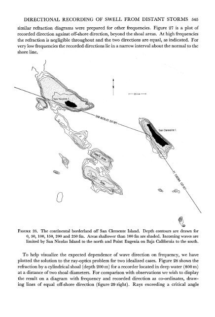
DIRECTIONAL RECORDING OF SWELL FROM DISTANT STORMS 545similar refraction diagrams were prepared for other frequencies. Figure 27 is a plot <strong>of</strong>recorded direction against <strong>of</strong>f-shore direction, beyond the shoal areas. At high frequenciesthe refraction is negligible throughout and the two directions are equal, as indicated. Forvery low frequencies the recorded directions lie in a narrow interval about the normal to theshore line.120 km I-HS4* N,014San Clemente I.FIGURE 25. The continental borderland <strong>of</strong>f San Clemente Island. Depth contours are drawn for0, 50, 100, 150, 200 and 250 fm. Areas shallower than 100 fm are shaded. Incoming waves arelimited by San Nicolas Island to the north and Point Eugenia on Baja California to the south.To help visualize the expected dependence <strong>of</strong> wave direction on frequency, we haveplotted the solution to the ray-optics problem for two idealized cases. Figure 28 shows therefraction by a cylindrical shoal (depth 200 m) for a recorder located in deep water (800 m)at a distance <strong>of</strong> two shoal diameters. For comparison with observations we wish to displaythe result on a diagram with frequency and recorded direction as co-ordinates, drawinglines <strong>of</strong> equal <strong>of</strong>f-shore direction (figure 29 right). Rays exceeding a critical angle