D E S C R I P T I O N O F W O R K - MEGAPOLI - Dmi
D E S C R I P T I O N O F W O R K - MEGAPOLI - Dmi
D E S C R I P T I O N O F W O R K - MEGAPOLI - Dmi

Create successful ePaper yourself
Turn your PDF publications into a flip-book with our unique Google optimized e-Paper software.
<strong>MEGAPOLI</strong> 212520<br />
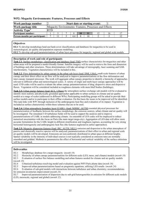
WP2: Megacity Environments: Features, Processes and Effects<br />
Work package number 2 Start date or starting event: 1<br />
Work package title Megacity Environments: Features, Processes and Effects<br />
Activity Type 1 RTD<br />
Participant number: 1 5 7 8 10 11 12 16 17<br />
Person-months per participant: 7 11 5 4,4 8 10 2 3 12<br />
Objectives<br />
O2.1 To develop morphology/land-use/land-cover classifications and databases for megacities to be used in<br />
meteorological, air quality and population exposure modelling.<br />
O2.2 To develop sub-grid parameterisations of urban layer processes for megacity, regional and global scale models<br />
Description of work and role of participants<br />
Task 2.1: Surface morphology: classification and database (lead: FMI) surface characteristics for megacities and other<br />
urban areas will be prepared a model-friendly format. Satellite imagery will be used to retrieve the form and dimension<br />
of buildings and other structures. These determinations will take advantage of stereography, laser scanning and SARinterferometry.<br />
Vegetation characteristics will be included in this.<br />
Task 2.2: Flow deformation by urban canopy in the urban sub-layer (lead: DMI, UHel), small-scale features of urban<br />
canopy and their direct effect on air flow will be analysed to improve parameterizations of the flow deformation and<br />
inter-canopy transport processes. The work will aggregate urban canopy properties to identify a hierarchy of approaches<br />
relevant to different urban and meteorological scales. A variety of single and multi-layer canopy approaches will be<br />
used. CFD codes will be used to evaluate the urban canopy parameterizations of drag, dispersive stress and dispersive<br />
fluxes. Vegetation will be considered included as roughness elements with more bluff bodies (buildings).<br />
Task 2.3: Urban energy balance (lead: KCL, UHam) the atmosphere-surface exchange sub-models will be evaluated to<br />
identify most realistic and physically grounded approaches applicable to urban surfaces in climate and air quality<br />
models at a range of scales (addressed in different WPs). Participating modelling groups will be asked to provide their<br />
surface models and/or to participate in their offline evaluation. On this basis the issues to be improved will be identified.<br />
This task links with WP1 through inclusion of the anthropogenic heat flux and evaluation of its impact. Vegetation is<br />
included as surface characteristic within these schemes that are to be used.<br />
Task 2.4: Urban atmospheric boundary layer (UABL) (lead: NERSC, AUTH) essential physical processes for<br />
parameterization of feedbacks between the surface morphology, the emission sources, urban climate and air quality will<br />
be investigated. The simulated 3-D turbulence fields will be used to support the analysis and to improve<br />
parameterizations of UABL in models addressing climate. An ensemble of LES codes will be employed to reduce<br />
numerical uncertainties with the focus on Paris (the main target mega-city). Aggregation of LES data will allow more<br />
accurate formulation for the UABL height in different stratification and roughness regimes, accounting for very strong<br />
horizontal heterogeneity and anthropogenic heat flux (the features neglected in earlier approaches).<br />
Task 2.5: Megacity dispersion features (lead: JRC, AUTH, NILU) emission and dispersion to the urban atmosphere of<br />
passive and chemically reactive species will be analyzed; parameterizations of their effect in urban and regional scale<br />
air quality models will be developed. Emissions are non-uniformly distributed in urban space at different heights.<br />
Spatial variability in the intensity of individual sources is not typically considered as emission rates are normally<br />
smoothed and gridded. Methods to parameterize the effect of horizontal and vertical variability of the surface emissions<br />
will be investigated.<br />
Deliverables<br />
D2.1 Morphology database for a target megacity (month 18)<br />
D2.2 Hierarchy of urban canopy parameterisations for different scale (LES, meso, and climate) models (month 18)<br />
D2.3 Evaluation of surface flux balance modelling and urban features needed for climate and air quality models<br />
(month 18)<br />
D2.4 Urbanized turbulence-resolving model and evaluation against WP3 Paris plume data (month 36)<br />
D2.5 Improved urban parameterizations based on prognostic equations, utilizing LES results (month 24)<br />
D2.6 Evaluation of sub-grid models with interactions between turbulence and urban chemistry; recommendations<br />
for emission inventories improvement (month 24)<br />
D2.7 Improved parameterization of dispersion due to sub-grid heterogeneities in emission for different scale models<br />
(LES, mesoscale, regional and global) (month 32)<br />
35