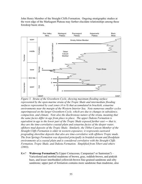
John Henry Member <strong>of</strong> <strong>the</strong> Straight Cliffs Formation. Ongoing stratigraphic studies at<strong>the</strong> west edge <strong>of</strong> <strong>the</strong> Markagunt Plateau may fur<strong>the</strong>r elucidate relationships among <strong>the</strong>seforedeep basin strata.Figure 5. Strata <strong>of</strong> <strong>the</strong> Greenhorn Cycle, showing maximum flooding surfacerepresented by <strong>the</strong> open-marine strata <strong>of</strong> <strong>the</strong> Tropic Shale and intermediate floodingsurfaces represented by coal zones (4 to 9) that accumulated in brackish, estuarineenvironments near <strong>the</strong> margin <strong>of</strong> <strong>the</strong> <strong>West</strong>ern Interior Sea. Note numerous smaller cyclessuperimposed on <strong>the</strong> larger Greenhorn Cycle, which are due to changes in subsidence,compaction, and climate. Note also <strong>the</strong> diachronous nature <strong>of</strong> <strong>the</strong> strata, meaning that<strong>the</strong> same facies differ in age from place to place. The upper Dakota Formation isequivalent in age to <strong>the</strong> lower part <strong>of</strong> <strong>the</strong> Tropic Shale exposed far<strong>the</strong>r east ― that is,<strong>the</strong>y are <strong>the</strong> time-correlative coastal-plain and estuarine facies <strong>of</strong> <strong>the</strong> deeper water,<strong>of</strong>fshore mud deposits <strong>of</strong> <strong>the</strong> Tropic Shale. Similarly, <strong>the</strong> Tibbet Canyon Member <strong>of</strong> <strong>the</strong>Straight Cliffs Formation is older in western exposures; it respresents eastwardprograding shoreline deposits that also are time-correlative with <strong>of</strong>fshore Tropic muds.The Iron Springs Formation was deposited principally in braided-stream and floodplainenvironments <strong>of</strong> a coastal plain and is considered correlative with <strong>the</strong> Straight CliffsFormation, Tropic Shale, and Dakota Formation. Simplified from Tibert and o<strong>the</strong>rs(2003).Kw? Wahweap Formation(?) (Upper Cretaceous, Campanian? or Santonian?) –Varicolored and mottled mudstone <strong>of</strong> brown, gray, reddish-brown, and pinkishhues, and lesser interbedded yellowish-brown fine-grained sandstone and siltysandstone; upper part <strong>of</strong> formation contains more sandstone than mudstone, also55
noted by Moore and Straub (2001) and Moore and o<strong>the</strong>rs (2004); deposited inbraided river and floodplain environments <strong>of</strong> a coastal plain by nor<strong>the</strong>ast-flowingrivers longitudinal to <strong>the</strong> foreland basin that tapped sources in <strong>the</strong> Cordilleranmagmatic arc and Mogollon Highlands (Pollock, 1999; Lawton and o<strong>the</strong>rs, 2003;Eaton, 2006); Eaton and o<strong>the</strong>rs (1999a) and Eaton (2006) reported enigmaticfossil mammals from near <strong>the</strong> base and top <strong>of</strong> <strong>the</strong> formation in Cedar Canyon thatmay be Campanian, and Lawton and o<strong>the</strong>rs (2003) reported middle Campanianpollen from <strong>the</strong> upper part <strong>of</strong> <strong>the</strong> formation near Webster Flat (we also recoveredSantonian to Campanian pollen near Webster Flat); Jinnah and o<strong>the</strong>rs (2009) andLarsen and o<strong>the</strong>rs (2010) reported an 40 Ar/ 39 Ar age <strong>of</strong> 80.6 ± 0.3 Ma (Campanian)on lower Wahweap strata on <strong>the</strong> Kaiparowits Plateau; measurements from <strong>the</strong>map show that <strong>the</strong> Wahweap(?) Formation is about 800 feet (245 m) thick belowCedar Breaks National Monument and south <strong>of</strong> Blowhard Mountain; Moore andStraub (2001) measured 760 feet (230 m) <strong>of</strong> strata in Cedar Canyon that we assignto Wahweap(?). If <strong>the</strong> lower conglomerate <strong>of</strong> <strong>the</strong> Grand Castle Formation is notequivalent to <strong>the</strong> Drip Tank Member <strong>of</strong> <strong>the</strong> Straight Cliffs Formation, strata heremapped as Wahweap(?) may simply be <strong>the</strong> upper part <strong>of</strong> <strong>the</strong> Straight CliffsFormation (John Henry Member equivalent); ongoing stratigraphic studies mayhelp assess <strong>the</strong> validity <strong>of</strong> our tentative correlation to early to middle CampanianWahweap strata on <strong>the</strong> Kaiparowits Plateau, a correlation initially proposed byEaton and o<strong>the</strong>rs (1999a) and Moore and Straub (2001).KsuStraight Cliffs Formation, upper unit (Upper Cretaceous, Santonian[?] toTuronian) – Consists <strong>of</strong> strata widely interpreted as equivalent to <strong>the</strong> SmokyHollow and John Henry Members <strong>of</strong> <strong>the</strong> Straight Cliffs Formation on <strong>the</strong>Kaiparowits Plateau, which form an overall regressive sequence following <strong>the</strong> lastmarine incursion <strong>of</strong> <strong>the</strong> <strong>West</strong>ern Interior Seaway (see, for example, Eaton ando<strong>the</strong>rs, 2001; Moore and Straub, 2001; Tibert and o<strong>the</strong>rs, 2003). Lower, SmokyHollow-equivalent strata are slope-forming, brown and gray mudstone, shale, andinterbedded yellowish-brown fine-grained sandstone; lower part contains a fewthin coal beds, common carbonaceous shale, and several thin oyster coquina beds;on <strong>the</strong> Kaiparowits Plateau, upper contact corresponds to <strong>the</strong> top <strong>of</strong> <strong>the</strong> Calicobed, which Moore and Straub (2001, <strong>the</strong>ir subunit 4 <strong>of</strong> interval A) suggested maybe present in Cedar Canyon about 285 feet (87 m) above <strong>the</strong> base <strong>of</strong> <strong>the</strong>formation; this sandstone is about 30 feet (9 m) thick and is not distinctive – itlacks pebbles and we were unable to use this bed as a marker horizon; however,we did locally map a thin pebble conglomerate about 330 feet (100 m) above <strong>the</strong>base <strong>of</strong> <strong>the</strong> formation in <strong>the</strong> sou<strong>the</strong>rn part <strong>of</strong> <strong>the</strong> Webster Flat quadrangle, whichmay be <strong>the</strong> Calico bed; Smoky Hollow strata are middle to upper Turonian basedon a diverse assemblage <strong>of</strong> mollusks, benthic foraminifera, and ostracods fromCedar Canyon exposures (Eaton and o<strong>the</strong>rs, 2001; Tiebert and o<strong>the</strong>rs, 2003);Eaton and o<strong>the</strong>rs (2001) measured 364 feet (110 m) <strong>of</strong> strata that likely belong to<strong>the</strong> Smoky Hollow Member, <strong>the</strong> lower 167 feet (54 m) <strong>of</strong> which are brackish andan order <strong>of</strong> magnitude thicker than equivalent brackish strata on <strong>the</strong> KaiparowitsPlateau, reflecting greater subsidence rates in <strong>the</strong> western part <strong>of</strong> <strong>the</strong> foredeep56
- Page 1 and 2:
! !! !!! ! ! !! ! ! ! !! ! !! !! !
- Page 3 and 4:
MAP UNIT DESCRIPTIONSQUATERNARYAllu
- Page 5 and 6: Qafc Coalesced fan alluvium of Paro
- Page 7 and 8: glacial deposits and features that
- Page 9 and 10: (Tbhv) and Dakota (Kd and Ktd) Form
- Page 11 and 12: typically mapped where lava flows d
- Page 13 and 14: that range in age from Miocene to H
- Page 15 and 16: fronts (except at Dry Valley, immed
- Page 17 and 18: the quadrangle; no fault that postd
- Page 19 and 20: Qbw, QbwcWater Canyon lava flow and
- Page 21 and 22: others, 2007); lava flow is typical
- Page 23 and 24: Mahogany Hill, about 500 feet (150
- Page 25 and 26: lava flow (Tbbm) that conceal the u
- Page 27 and 28: TERTIARYpreserved in down-dropped b
- Page 29 and 30: and Rowley and others (in preparati
- Page 31 and 32: field (or possibly coeval batholith
- Page 33 and 34: hidden by shadow; we tentatively as
- Page 35 and 36: esistant crystal-poor rhyolite tuff
- Page 37 and 38: thickness uncertain but outcrop pat
- Page 39 and 40: divide between Red Creek and Little
- Page 41 and 42: pyroxene (5%), and sanidine (trace)
- Page 43 and 44: unconformityThe Leach Canyon Format
- Page 45 and 46: unconformityMa (Best and others, 19
- Page 47 and 48: interval, and a lower limestone int
- Page 49 and 50: Figure 3. View northwest to North V
- Page 51 and 52: dark-yellowish-orange, grayish-pink
- Page 53 and 54: TKgc Grand Castle Formation, undivi
- Page 55: track (the latter found by Eric Rob
- Page 59 and 60: shoreface, beach, lagoonal, and est
- Page 61 and 62: water deposits of Cenomanian age (N
- Page 63 and 64: 62Figure 7. Cedar Mountain Formatio
- Page 65 and 66: leached white under the Cretaceous
- Page 67 and 68: ACKNOWLEDGMENTSThis geologic map is
- Page 69 and 70: Anderson, R.E., and Christenson, G.
- Page 71 and 72: Biek, R.F., Rowley, P.D., Hayden, J
- Page 73 and 74: field guide (The Mackin Volume): Ut
- Page 75 and 76: 2001, Cretaceous and early Tertiary
- Page 77 and 78: Hacker, D.B., Rowley, P.D., Blank,
- Page 79 and 80: Kurlich, R.A., III, 1990, Geology o
- Page 81 and 82: Maldonado, F., and Moore, R.C., 199
- Page 83 and 84: Flagstaff-Green River basins [abs.]
- Page 85 and 86: elation to other igneous centers in
- Page 87 and 88: Schulman, E., 1956, Dendroclimatic
- Page 89: Van Kooten, G.K., 1988, Structure a
- Page 92: 113°00'112°00'15BV20R i v e rCCNP