

Interim Geologic Map of the West Part of - Utah Geological Survey
Interim Geologic Map of the West Part of - Utah Geological Survey
Interim Geologic Map of the West Part of - Utah Geological Survey

You also want an ePaper? Increase the reach of your titles
YUMPU automatically turns print PDFs into web optimized ePapers that Google loves.
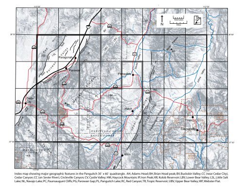
113°00'112°00'15BV20R i v e rCCNPLATEA00 5KilometersMiles5BRMRMCP38°00'56Hurricane fault130CedarCityCCPG14R e d H i l l sRedHillsParagonahP a r o w a n V a l l e yParowanLSLWFfaultfaultCedarBreaksNationalMonument148143H u r r i c a n eBHParowanCVfaultParagonahC l i f f sIPM a r k a g u n t P l a t e a uI R O N C O U N T YPLUBVHMLBV143G A R F I E L D C O U N T YS e v i e rPanguitchHatch89Sevier ValleyPC12u p p e r S e v i e r V a l l e yfaultRCE a s tS u n s e t C l i f f sTRPaunsaugunt PlateauAHSevier PlateauF o r kBryceCanyonNationalParkS e v i erTropicR i v e rCannonvilleJohns ValleyGrandStaircase-EscalanteNationalMonument38°00'37°30'NLK A N E C O U N T Y14Sevier37°30'ZionNationalParkK o l o b T e r r a c eW A S H I N G T O NC O U N T YKR89AltonPariaGrand Staircase-EscalanteNationalMonumentRiver113°00'Index map showing major geographic features in <strong>the</strong> Panguitch 30´ x 60´ quadrangle. AH, Adams Head; BH, Brian Head peak; BV, Buckskin Valley; CC (near Cedar City),Cedar Canyon; CC (on Sevier River), Circleville Canyon; CV, Castle Valley; HM, Haycock Mountain; IP, Iron Peak; KR, Kolob Reservoir; LBV, Lower Bear Valley; LSL, Little SaltLake; NL, Navajo Lake; PC, Paunsaugunt Cliffs; PG, Parowan Gap; PL, Panguitch Lake; RC, Red Canyon; TR, Tropic Reservoir; UBV, Upper Bear Valley; WF, Webster Flat.112°00'


