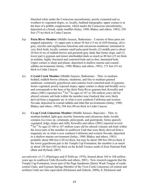
Figure 8. View north to <strong>the</strong> CedarMountain Formation (Kcm) in <strong>the</strong>SW1/4SE1/4SW1/4 section 16, T. 36S., R. 10 W. Swelling mudstone <strong>of</strong>light-gray, reddish-brown, andpurplish hues contrast sharply withyellowish-brown and olive-graymudstone <strong>of</strong> overlying DakotaFormation (Kd). About 40 feet (12m) above <strong>the</strong> base <strong>of</strong> <strong>the</strong> DakotaFormation <strong>the</strong>re is a ledge-forming20-foot-thick (6 m) pebbly sandstoneand conglomerate with roundedquartzite and black chert clasts, andit is this bed that may have beenmistaken in <strong>the</strong> past for <strong>the</strong> basalCretaceous unconformity. Jcw =Winsor Member <strong>of</strong> CarmelFormation.unconformity (K) No rocks <strong>of</strong> late Middle Jurassic to middle Early Cretaceous age arepreserved in southwest <strong>Utah</strong>. This is because during this time, <strong>the</strong> back-bulge basin thatdeveloped in front <strong>of</strong> <strong>the</strong> Sevier orogenic belt had migrated eastward, and much <strong>of</strong> <strong>Utah</strong>was a forebulge high, a broad, gentle uplift that was high enough to undergo a prolongedperiod <strong>of</strong> modest erosion (see, for example, Willis, 1999). In this area, this 60-millionyear-longgap in <strong>the</strong> rock record is marked by a bleached zone at <strong>the</strong> top <strong>of</strong> <strong>the</strong> WinsorMember <strong>of</strong> <strong>the</strong> Carmel Formation (figure 7). The Cretaceous unconformity cuts downsection to <strong>the</strong> west, where, on <strong>the</strong> south flank <strong>of</strong> <strong>the</strong> Pine Valley Mountains, first Winsor,<strong>the</strong>n Paria River, and finally Crystal Creek strata are completely eroded away, so that atGunlock <strong>the</strong> Cedar Mountain Formation rests upon <strong>the</strong> Co-op Creek Limestone, <strong>the</strong>lower member <strong>of</strong> <strong>the</strong> Carmel Formation (Biek and o<strong>the</strong>rs, 2009).JURASSICCarmel Formation (Middle Jurassic)Nomenclature follows that <strong>of</strong> Doelling and Davis (1989); deposited in a shallow inlandsea <strong>of</strong> a back-bulge basin, toge<strong>the</strong>r with <strong>the</strong> underlying Temple Cap Formation, <strong>the</strong> firstclear record <strong>of</strong> <strong>the</strong> effects <strong>of</strong> <strong>the</strong> Sevier orogeny in southwestern <strong>Utah</strong>; age from Imlay(1980); measured thicknesses in Cedar Canyon are from Doug Sprinkel, <strong>Utah</strong> <strong>Geologic</strong>al<strong>Survey</strong>, written communication, June 22, 2010).JcwWinsor Member (Middle Jurassic, Callovian to Bathonian) – Light-reddishbrown,fine- to medium-grained sandstone and siltstone; uppermost beds typically63
leached white under <strong>the</strong> Cretaceous unconformity; poorly cemented and sowea<strong>the</strong>rs to vegetated slopes, or, locally, badland topography; upper contact is at<strong>the</strong> base <strong>of</strong> a pebble conglomerate, which marks <strong>the</strong> Cretaceous unconformity;deposited on a broad, sandy mudflat (Imlay, 1980; Blakey and o<strong>the</strong>rs, 1983); 250feet (75 m) thick in Cedar Canyon.JcpJcxJccParia River Member (Middle Jurassic, Bathonian) – Consists <strong>of</strong> three parts notmapped separately: (1) upper part is about 50 feet (15 m) <strong>of</strong> cliff-forming, olivegray,micritic and argillaceous limestone and calcareous mudstone; laminated invery thick beds; locally contains small pelecypod fossils; (2) middle part is about20 feet (6 m) <strong>of</strong> reddish-brown and greenish-gray shale that forms slope; and (3)lower part is gypsum and minor interbedded shale as much as 80 feet (25 m) thickin nodular, highly fractured and contorted beds and as thin, laminated beds.Upper contact is sharp and planar; deposited in shallow-marine and coastalsabkhaenvironments (Imlay, 1980; Blakey and o<strong>the</strong>rs, 1983); 173 feet (53 m)thick in Cedar Canyon.Crystal Creek Member (Middle Jurassic, Bathonian) – Thin- to mediumbedded,reddish-brown siltstone, mudstone, and fine to medium-grainedsandstone; commonly gypsiferous and contains local contorted pods <strong>of</strong> gypsum;forms vegetated, poorly exposed slopes; upper contact is sharp and broadly wavyand corresponds to <strong>the</strong> base <strong>of</strong> <strong>the</strong> thick Paria River gypsum bed; Kowallis ando<strong>the</strong>rs (2001) reported two 40 Ar/ 39 Ar ages <strong>of</strong> 167 to 166 million years old foraltered volcanic ash beds within <strong>the</strong> member near Gunlock that were likelyderived from a magmatic arc in what is now sou<strong>the</strong>rn California and westernNevada; deposited in coastal-sabkha and tidal-flat environments (Imlay, 1980;Blakey and o<strong>the</strong>rs, 1983); 294 feet (90 m) thick in Cedar Canyon.Co-op Creek Limestone Member (Middle Jurassic, Bajocian) − Thin- tomedium-bedded, light-gray micritic limestone and calcareous shale; locallycontains Isocrinus sp. columnals, pelecypods, and gastropods; forms sparselyvegetated, ledgy slopes and cliffs; Kowallis and o<strong>the</strong>rs (2001) reported several40 Ar/ 39 Ar ages <strong>of</strong> 168 to 167 million years old for altered volcanic ash beds within<strong>the</strong> lower part <strong>of</strong> <strong>the</strong> member in southwest <strong>Utah</strong> that were likely derived from amagmatic arc in what is now sou<strong>the</strong>rn California and western Nevada; depositedin a shallow-marine environment (Imlay, 1980; Blakey and o<strong>the</strong>rs, 1983);probably about 400 feet (120 m) thick, but may be about 300 feet (90 m) thick if<strong>the</strong> lower gypsiferous part is <strong>the</strong> Temple Cap Formation; <strong>the</strong> member is as muchas about 350 feet (105 m) thick on <strong>the</strong> Kolob Terrace north <strong>of</strong> Zion National Park(Biek and Hylland, 2007).unconformity (J-2?) (Pipiringos and O’Sullivan, 1978); formed about 169 to 168 millionyears ago in southwest <strong>Utah</strong> (Kowallis and o<strong>the</strong>rs, 2001). New research suggests that <strong>the</strong>Temple Cap Formation, lower part <strong>of</strong> <strong>the</strong> Page Sandstone (Harris Wash Tongue <strong>of</strong> southcentral<strong>Utah</strong>), and Gypsum Springs Member <strong>of</strong> <strong>the</strong> Twin Creek Limestone (<strong>of</strong> central andnor<strong>the</strong>rn <strong>Utah</strong>) are time equivalent (Dickinson and Gehrels, 2009a, b; Dickinson and64
- Page 1 and 2:
! !! !!! ! ! !! ! ! ! !! ! !! !! !
- Page 3 and 4:
MAP UNIT DESCRIPTIONSQUATERNARYAllu
- Page 5 and 6:
Qafc Coalesced fan alluvium of Paro
- Page 7 and 8:
glacial deposits and features that
- Page 9 and 10:
(Tbhv) and Dakota (Kd and Ktd) Form
- Page 11 and 12:
typically mapped where lava flows d
- Page 13 and 14: that range in age from Miocene to H
- Page 15 and 16: fronts (except at Dry Valley, immed
- Page 17 and 18: the quadrangle; no fault that postd
- Page 19 and 20: Qbw, QbwcWater Canyon lava flow and
- Page 21 and 22: others, 2007); lava flow is typical
- Page 23 and 24: Mahogany Hill, about 500 feet (150
- Page 25 and 26: lava flow (Tbbm) that conceal the u
- Page 27 and 28: TERTIARYpreserved in down-dropped b
- Page 29 and 30: and Rowley and others (in preparati
- Page 31 and 32: field (or possibly coeval batholith
- Page 33 and 34: hidden by shadow; we tentatively as
- Page 35 and 36: esistant crystal-poor rhyolite tuff
- Page 37 and 38: thickness uncertain but outcrop pat
- Page 39 and 40: divide between Red Creek and Little
- Page 41 and 42: pyroxene (5%), and sanidine (trace)
- Page 43 and 44: unconformityThe Leach Canyon Format
- Page 45 and 46: unconformityMa (Best and others, 19
- Page 47 and 48: interval, and a lower limestone int
- Page 49 and 50: Figure 3. View northwest to North V
- Page 51 and 52: dark-yellowish-orange, grayish-pink
- Page 53 and 54: TKgc Grand Castle Formation, undivi
- Page 55 and 56: track (the latter found by Eric Rob
- Page 57 and 58: noted by Moore and Straub (2001) an
- Page 59 and 60: shoreface, beach, lagoonal, and est
- Page 61 and 62: water deposits of Cenomanian age (N
- Page 63: 62Figure 7. Cedar Mountain Formatio
- Page 67 and 68: ACKNOWLEDGMENTSThis geologic map is
- Page 69 and 70: Anderson, R.E., and Christenson, G.
- Page 71 and 72: Biek, R.F., Rowley, P.D., Hayden, J
- Page 73 and 74: field guide (The Mackin Volume): Ut
- Page 75 and 76: 2001, Cretaceous and early Tertiary
- Page 77 and 78: Hacker, D.B., Rowley, P.D., Blank,
- Page 79 and 80: Kurlich, R.A., III, 1990, Geology o
- Page 81 and 82: Maldonado, F., and Moore, R.C., 199
- Page 83 and 84: Flagstaff-Green River basins [abs.]
- Page 85 and 86: elation to other igneous centers in
- Page 87 and 88: Schulman, E., 1956, Dendroclimatic
- Page 89: Van Kooten, G.K., 1988, Structure a
- Page 92: 113°00'112°00'15BV20R i v e rCCNP