Protected Area Network in Orissa - Vasundhara
Protected Area Network in Orissa - Vasundhara
Protected Area Network in Orissa - Vasundhara
- No tags were found...

You also want an ePaper? Increase the reach of your titles
YUMPU automatically turns print PDFs into web optimized ePapers that Google loves.
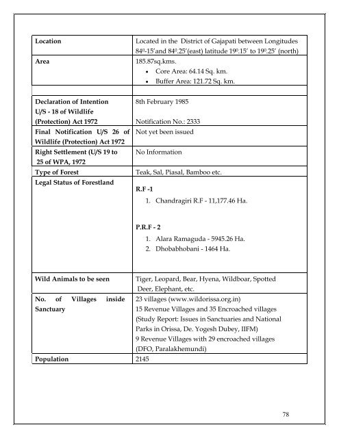
Location<strong>Area</strong>Located <strong>in</strong> the District of Gajapati between Longitudes84 0 -15’and 84 0 .25’(east) latitude 19 0 .15’ to 19 0 .25’ (north)185.87sq.kms.• Core <strong>Area</strong>: 64.14 Sq. km.• Buffer <strong>Area</strong>: 121.72 Sq. km.Declaration of IntentionU/S - 18 of Wildlife(Protection) Act 1972F<strong>in</strong>al Notification U/S 26 ofWildlife (Protection) Act 1972Right Settlement (U/S 19 to25 of WPA, 1972Type of ForestLegal Status of Forestland8th February 1985Notification No.: 2333Not yet been issuedNo InformationTeak, Sal, Piasal, Bamboo etc.R.F -11. Chandragiri R.F - 11,177.46 Ha.P.R.F - 21. Alara Ramaguda - 5945.26 Ha.2. Dhobabhobani - 1464 Ha.Wild Animals to be seen Tiger, Leopard, Bear, Hyena, Wildboar, SpottedDeer, Elephant, etc.No. of Villages <strong>in</strong>side 23 villages (www.wildorissa.org.<strong>in</strong>)Sanctuary15 Revenue Villages and 35 Encroached villages(Study Report: Issues <strong>in</strong> Sanctuaries and NationalParks <strong>in</strong> <strong>Orissa</strong>, De. Yogesh Dubey, IIFM)9 Revenue Villages with 29 encroached villages(DFO, Paralakhemundi)Population 214578