Valuation of Biodiversity Benefits (OECD)
Valuation of Biodiversity Benefits (OECD)
Valuation of Biodiversity Benefits (OECD)
- No tags were found...

Create successful ePaper yourself
Turn your PDF publications into a flip-book with our unique Google optimized e-Paper software.
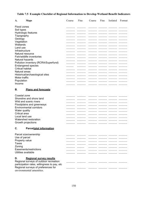
Table 7.5 Example Checklist <strong>of</strong> Regional Information to Develop Wetland Benefit IndicatorsA. Maps Coarse Fine Coarse Fine Isolated FormatFlood zones ______ ______ ______ ______ ______ ______Soil types ______ ______ ______ ______ ______ ______Hydrologic features ______ ______ ______ ______ ______ ______Topography ______ ______ ______ ______ ______ ______Geology ______ ______ ______ ______ ______ ______Vegetation ______ ______ ______ ______ ______ ______Wetlands ______ ______ ______ ______ ______ ______Land use ______ ______ ______ ______ ______ ______Infrastructure ______ ______ ______ ______ ______ ______Natural resource ______ ______ ______ ______ ______ ______Fish/wildlife inventories ______ ______ ______ ______ ______ ______Natural hazards ______ ______ ______ ______ ______ ______Pollution inventory (RCRA/Superfund) ______ ______ ______ ______ ______ ______Endangered species _____ ______ ______ ______ ______ ______Critical habitat ______ ______ ______ ______ ______ ______Natural areas ______ ______ ______ ______ ______ ______Historical/archaeological sites ______ ______ ______ ______ ______ ______Motor traffic ______ ______ ______ ______ ______ ______Population ______ ______ ______ ______ ______ ______Income ______ ______ ______ ______ ______ ______B. Plans and forecastsCoastal zone ______ ______ ______ ______ ______ ______Shoreline and shore land ______ ______ ______ ______ ______ ______Wild and scenic rivers ______ ______ ______ ______ ______ ______Floodplains and greenways ______ ______ ______ ______ ______ ______Environmental corridors ______ ______ ______ ______ ______ ______Water quality ______ ______ ______ ______ ______ ______Critical area ______ ______ ______ ______ ______ ______Local land use ______ ______ ______ ______ ______ ______Watershed restoration ______ ______ ______ ______ ______ ______Growth projections ______ ______ ______ ______ ______ ______C. Parcel/plot informationParcel size/ownership ______ ______ ______ ______ ______ ______Use <strong>of</strong> parcel ______ ______ ______ ______ ______ ______Property value ______ ______ ______ ______ ______ ______Taxes ______ ______ ______ ______ ______ ______Zoning ______ _____ ______ ______ ______ ______Easements/restrictions ______ ______ ______ ______ ______ ______Utilities available ______ ______ ______ ______ ______ ______D. Regional survey resultsRegional surveys <strong>of</strong> outdoor recreation: ______ ______ ______ ______ ______ ______participation rates, willingness to pay, etcRegional surveys <strong>of</strong> preferences for ______ ______ ______ ______ ______ ______environmental amenities.150