iosphere (that is, the national parks are meant to be the core of the reserve and, as such, remain protected forconservation purposes).• Overlap includes all areas where strictly protected areas overlap with areas designated for extractive (ornatural resource) uses.Sources:• MARNR, Mapa de Áreas Bajo Régimen de Administración Especial, Photocopy (Caracas, Venezuela:Dirección General Sectorial de Planificación y Ordenación del Ambiente, 1983 with updated boundaries in1999, unpublished draft). Scale: 1:1,000,000.• MARNR, Mapa de Áreas Bajo Régimen de Administración Especial, Photocopy (Caracas, Venezuela:Dirección General Sectorial de Planificación y Ordenación del Ambiente, 1998, printed). Scale: 1:2,000,000.• H. Eva and S. Jones, A forest map of South America (Ispra, Italy: Tropical Ecosystem EnvironmentObservation by Satellite (TREES), unpublished data). Scale: 1: 1,000,000.• O. Huber and C. Alarcón, Mapa de Vegetación de Venezuela (Caracas, Venezuela: MARNR/ The NatureConservancy, 1988). Scale: 1:2,000,000.• O. Huber, Venezuelan Guayana Vegetation Map (Caracas, Venezuela: CVG Edelca/Missouri BotanicalGardens, 1995). Scale: 1:2,000,000.Methodology:• Huber’s Venezuelan Guayana Vegetation Map was digitized and added to the digital version of the Mapa deVegetación de Venezuela (area north of the Orinoco) to obtain an ecosystem layer. The Guayana map is anupdate to the original work published for the whole of Venezuela.• To obtain forest ecosystems, we combined data from TREES and Huber’s maps of potential vegetation types.TREES data were resampled to the scale of Huber’s maps, 1:2,000,000 resolution. TREES classes were thenaggregated into forest and non-forest, the latter including fragmented forest. Each TREES forest pixel wasthen coded according to ecosystem type from Huber’s data, to produce a dataset on forest type. This layer wasused to estimate forest cover by ecosystem type. In addition, the layer was used with the protected areasdataset to estimate percentage of protection for each forest type –lowland, submontane, and montane.Additional methodology for Maps 4-6:• The MARNR Mapa de Áreas Bajo Régimen de Administración Especial 1983 (with updated boundaries in1999) paper map was digitized, corrected with the MARNR 1998 published map, and checked by protectedareas experts in Venezuela.• Protected areas were divided in two categories: strictly protected (corresponds to IUCN categories I to IV)and those designated for resource use (IUCN categories V and VI). Although IUCN lists Wildlife Reserves ascategory IV, we chose to categorize these protected areas as “designated for resource use,” since the primaryobjective of this category according to Venezuelan law is for wildlife use. Wildlife Reserves encompass lessthan 20,000 hectares.• Forest lots (lotes boscosos) are not part of the protected area (ABRAE) system. However, because these areasare also designated for extractive use (logging), we have chosen to include them in Map 5.Limitations• The TREES/Huber overlay resulted in a coarser version of the regional scale TREES map. While expertsagreed that the representation of forest ecosystems was more accurate under this scenario, the forest coverarea is slightly underestimated. For this reason, the analysis is appropriate for determining percentages ofecosystems that are protected, but not for representing total forest cover. We have chosen to maintain theTREES layer in its original format as a more accurate representation of Venezuela’s forest cover.• Venezuela lacks a digital, georeferenced, national scale protected areas map that has been reviewed by theofficial cartographic office (known as the Instituto Geográfico de Venezuela “Simón Bolívar”). For thisreason, Maps 4 and 5 are based on schematic maps created by the Ministry of Environment.90
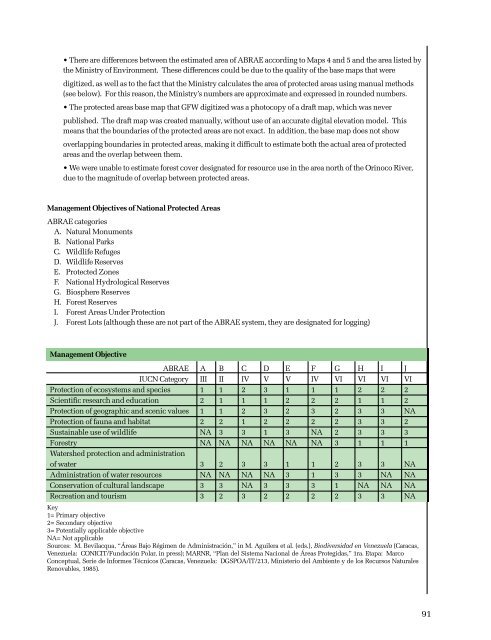
• There are differences between the estimated area of ABRAE according to Maps 4 and 5 and the area listed bythe Ministry of Environment. These differences could be due to the quality of the base maps that weredigitized, as well as to the fact that the Ministry calculates the area of protected areas using manual methods(see below). For this reason, the Ministry’s numbers are approximate and expressed in rounded numbers.• The protected areas base map that GFW digitized was a photocopy of a draft map, which was neverpublished. The draft map was created manually, without use of an accurate digital elevation model. Thismeans that the boundaries of the protected areas are not exact. In addition, the base map does not showoverlapping boundaries in protected areas, making it difficult to estimate both the actual area of protectedareas and the overlap between them.• We were unable to estimate forest cover designated for resource use in the area north of the Orinoco River,due to the magnitude of overlap between protected areas.Management Objectives of National Protected AreasABRAE categoriesA. Natural MonumentsB. National ParksC. Wildlife RefugesD. Wildlife ReservesE. Protected ZonesF. National Hydrological ReservesG. Biosphere ReservesH. Forest ReservesI. Forest Areas Under ProtectionJ. Forest Lots (although these are not part of the ABRAE system, they are designated for logging)Management ObjectiveABRAE A B C D E F G H I JIUCN Category III II IV V V IV VI VI VI VIProtection of ecosystems and species 1 1 2 3 1 1 1 2 2 2Scientific research and education 2 1 1 1 2 2 2 1 1 2Protection of geographic and scenic values 1 1 2 3 2 3 2 3 3 NAProtection of fauna and habitat 2 2 1 2 2 2 2 3 3 2Sustainable use of wildlife NA 3 3 1 3 NA 2 3 3 3Forestry NA NA NA NA NA NA 3 1 1 1Watershed protection and administrationof water 3 2 3 3 1 1 2 3 3 NAAdministration of water resources NA NA NA NA 3 1 3 3 NA NAConservation of cultural landscape 3 3 NA 3 3 3 1 NA NA NARecreation and tourism 3 2 3 2 2 2 2 3 3 NAKey1= Primary objective2= Secondary objective3= Potentially applicable objectiveNA= Not applicableSources: M. Bevilacqua, “Áreas Bajo Régimen de Administración,” in M. Aguilera et al. (eds.), Biodiversidad en Venezuela (Caracas,Venezuela: CONICIT/Fundación Polar, in press); MARNR, “Plan del Sistema Nacional de Áreas Protegidas,” 1ra. Etapa: MarcoConceptual, Serie de Informes Técnicos (Caracas, Venezuela: DGSPOA/IT/213, Ministerio del Ambiente y de los Recursos NaturalesRenovables, 1985).91
- Page 2 and 3:
The State of Venezuela’s ForestsA
- Page 5:
PresentationMan has become increasi
- Page 9 and 10:
ForewordForests help to slow global
- Page 11 and 12:
AcknowledgmentsGlobal Forest Watch
- Page 13 and 14:
Mining ............................
- Page 15 and 16:
6. Actual and Potential Conflicts B
- Page 18 and 19:
Key FindingsVenezuela is still home
- Page 20 and 21:
However, the forests of the Guayana
- Page 22 and 23:
2Political and Administrative Bound
- Page 24:
MAP 2Settlements in the Forests of
- Page 27 and 28:
In 1998, the Venezuelan Forest Serv
- Page 29 and 30:
Legal Instrument Year RelevanceDecr
- Page 31 and 32:
CHAPTER 2Forest Cover and Protectio
- Page 33 and 34:
13Forest CoverMAP 3Data on forest c
- Page 35 and 36:
• Lack of consistency in results.
- Page 37 and 38:
17Areas Strictly Protected for Cons
- Page 39 and 40:
Areas protected for natural resourc
- Page 41 and 42:
Actual and Potential Conflicts Betw
- Page 43 and 44:
Capacity to Manage Protected Areas
- Page 45 and 46:
CHAPTER 3Non-Extractive Value of Fo
- Page 47 and 48:
Wildlife Species Richness in the Gu
- Page 49 and 50:
Threatened and Endemic Species by S
- Page 51 and 52:
At least thirteen plants and animal
- Page 53 and 54:
The capture and collection of parro
- Page 55 and 56:
CHAPTER 4Forest Development TrendsV
- Page 57 and 58:
Imports, Exports, and National Prod
- Page 59 and 60: Industrial Wood Production, 1980-19
- Page 61 and 62: • In 1997, royalties and fees com
- Page 63 and 64: Status of Logging Concessions in th
- Page 65 and 66: Irregularities in Logging Concessio
- Page 67 and 68: Low extraction rates in the Guayana
- Page 69 and 70: The Guayana region lacks a transpar
- Page 71 and 72: The capacity for regeneration of co
- Page 73 and 74: MiningWhat is the relative importan
- Page 75 and 76: Venezuelan Gold and Diamond Product
- Page 77 and 78: • Concession owners are required
- Page 79 and 80: Foreign Mining Companies with Holdi
- Page 81 and 82: By nature, mining is a speculative
- Page 83 and 84: signs of contamination, 97 and anot
- Page 85 and 86: SettlementsHow are settlement patte
- Page 87 and 88: What is the impact of population ch
- Page 89 and 90: y these actors. In addition, becaus
- Page 91 and 92: CHAPTER 5ConclusionsGlobal Forest W
- Page 93 and 94: Providing Better Information for In
- Page 95 and 96: 18 Ministerio del Ambiente y de los
- Page 97 and 98: 37 MARN, Boletín Estadístico Fore
- Page 99 and 100: 62 R. Posada, “Algunos aspectos s
- Page 101 and 102: 83 Government of Venezuela (GOV), D
- Page 103 and 104: 103 Legislation does not define sta
- Page 105 and 106: Methodology:• Data on the locatio
- Page 107 and 108: • TREES from ATSR onboard the ERS
- Page 109: Maps 4-6, Figures 2-4Venezuela’s
- Page 113 and 114: Wildlife Restricted to Forests of t
- Page 115 and 116: Threatened Animals Used by Indigeno
- Page 117 and 118: Chapter 4: Forest Development Trend
- Page 119 and 120: Note: There are many inconsistencie
- Page 121 and 122: Annual Cutting Plans (Executed)Area
- Page 123 and 124: Management Area (ha) Contract Years
- Page 125 and 126: Table Sources:• Concession manage
- Page 127 and 128: Price of Gold, 1975-2000 (Figure 20
- Page 129 and 130: Methodology (Figure 23, Table 11, M
- Page 131 and 132: Change in Selected Indigenous Popul
- Page 133 and 134: iar with forest issues in Venezuela
- Page 135 and 136: Gydris Adrián Comisión Especial p
- Page 137 and 138: Ortegano, O. “Nueva Política For
- Page 139 and 140: Chapter 3: Non-timber Forest Produc
- Page 141 and 142: Dessene, P., and S. Strhal. “Situ
- Page 143 and 144: Hernández, L., P. Williams, R. Azu
- Page 145 and 146: Ojasti, J. “Fauna silvestre del e
- Page 147 and 148: Técnica Minera C.A. Inventario de
- Page 149 and 150: Nepstad, D., et al. “Large-scale
- Page 151 and 152: Government Industry Task Force on t
- Page 153 and 154: All data presented in this report a
- Page 155: GLOBAL FOREST WATCH (GFW)WORLD RESO