

Appendix L - Federal Emergency Management Agency
Appendix L - Federal Emergency Management Agency
Appendix L - Federal Emergency Management Agency

You also want an ePaper? Increase the reach of your titles
YUMPU automatically turns print PDFs into web optimized ePapers that Google loves.
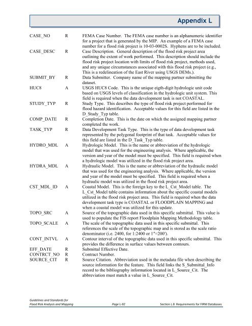
<strong>Appendix</strong> LCASE_NO R FEMA Case Number. The FEMA case number is an alphanumeric identifierfor a project that is generated by the MIP. An example of a FEMA casenumber for a flood risk project is 10-03-0002S. Hyphens are to be included.CASE_DESC R Case Description. General description of the flood risk project areaoutlining the extent of work performed. This description should include theflood risk project location with limits of flood risk project, methods used,and any unique circumstances associated with this flood risk project (e.g.,This is a redelineation of the East River using USGS DEMs.).SUBMIT_BY R Data Submitter. Company name of the mapping partner submitting thedataset.HUC8 A USGS HUC8 Code. This is the unique eigth-digit hydrologic unit codebased on USGS levels of classification in the hydrologic unit system. Thisfield is required when the data development task is not COASTAL.STUDY_TYP R Study Type. This describes the type of flood risk project performed forflood hazard identification. Acceptable values for this field are listed in theD_Study_Typ table.COMP_DATE R Completion Date. This is the date on which the assigned mapping partnercompleted the work.TASK_TYP R Data Development Task Type. This is the type of data development taskrepresented by the polygonal footprint of that task. Acceptable values forthis field are listed in the D_Task_Typ table.HYDRO_MDL A Hydrologic Model. This is the name or abbreviation of the hydrologicmodel that was used for the engineering analysis. Where applicable, theversion and year of the model must be specified. This field is required whena hydrologic model was utilized in the flood risk project area.HYDRA_MDL A Hydraulic Model. This is the name or abbreviation of the hydraulic modelthat was used for the engineering analysis. Where applicable, the versionand year of the model must be specified. This field is required when ahydraulic model was utilized in the flood risk project area.CST_MDL_ID A Coastal Model. This is the foreign key to the L_Cst_Model table. TheL_Cst_Model table contains information about the specific coastal modelsutilized in the flood risk project area. This field is required when the datadevelopment task type is COASTAL or FLOODPLAIN MAPPING andwhen a coastal model was utilized for this update.TOPO_SRC A Source of the topographic data used in this specific submittal. This value isused to populate the FIS report Floodplain Mapping Methodology table.TOPO_SCALE A The scale of the topographic data used in this specific submittal. Thisreferences the scale of the topographic map and is stored as the scale ratiodenominator (i.e. 2400, for 1:2400 or 1″=200′).CONT_INTVL A Contour interval of the topographic data used in this specific submittal. Thisprovides the difference in surface values between contours.EFF_DATE R Submittal Effective Date.CONTRCT_NO R Contract Number.SOURCE_CIT R Source Citation. Abbreviation used in the metadata file when describing thesource information for the feature. This field links the S_Submittal_Inforecord to the bibliography information located in L_Source_Cit. Theabbreviation must match a value in L_Source_Cit.Guidelines and Standards forFlood Risk Analysis and Mapping Page L-92 Section L.8 Requirements for FIRM Databases


