

Appendix L - Federal Emergency Management Agency
Appendix L - Federal Emergency Management Agency
Appendix L - Federal Emergency Management Agency

You also want an ePaper? Increase the reach of your titles
YUMPU automatically turns print PDFs into web optimized ePapers that Google loves.
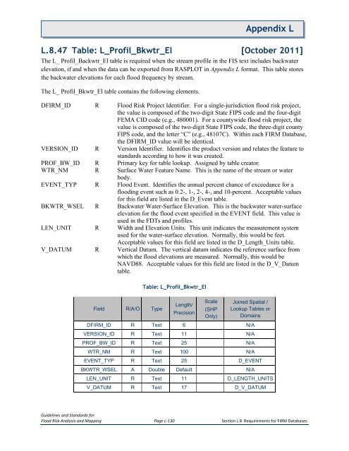
<strong>Appendix</strong> LL.8.47 Table: L_Profil_Bkwtr_El [October 2011]The L_ Profil_Backwtr_El table is required when the stream profile in the FIS text includes backwaterelevation, if and when the data can be exported from RASPLOT in <strong>Appendix</strong> L format. This table storesthe backwater elevations for each flood frequency by stream.The L_ Profil_Bkwtr_El table contains the following elements.DFIRM_ID R Flood Risk Project Identifier. For a single-jurisdiction flood risk project,the value is composed of the two-digit State FIPS code and the four-digitFEMA CID code (e.g., 480001). For a countywide flood risk project, thevalue is composed of the two-digit State FIPS code, the three-digit countyFIPS code, and the letter “C” (e.g., 48107C). Within each FIRM Database,the DFIRM_ID value will be identical.VERSION_ID R Version Identifier. Identifies the product version and relates the feature tostandards according to how it was created.PROF_BW_ID R Primary key for table lookup. Assigned by table creator.WTR_NM R Surface Water Feature Name. This is the name of the stream or waterbody.EVENT_TYP R Flood Event. Identifies the annual percent chance of exceedance for aflooding event such as 0.2-, 1-, 2-, 4-, and 10-percent. Acceptable valuesfor this field are listed in the D_Event table.BKWTR_WSEL R Backwater Water-Surface Elevation. This is the backwater water-surfaceelevation for the flood event specified in the EVENT field. This value isused in the FDTs and profiles.LEN_UNIT R Width and Elevation Units. This unit indicates the measurement systemused for the water-surface elevation. Normally, this would be feet.Acceptable values for this field are listed in the D_Length_Units table.V_DATUM R Vertical Datum. The vertical datum indicates the reference surface fromwhich the flood elevations are measured. Normally, this would beNAVD88. Acceptable values for this field are listed in the D_V_Datumtable.Table: L_Profil_Bkwtr_ElField R/A/O TypeLength/PrecisionScale(SHPOnly)Joined Spatial /Lookup Tables orDomainsDFIRM_ID R Text 6 N/AVERSION_ID R Text 11 N/APROF_BW_ID R Text 25 N/AWTR_NM R Text 100 N/AEVENT_TYP R Text 25 D_EVENTBKWTR_WSEL A Double Default N/ALEN_UNIT R Text 11 D_LENGTH_UNITSV_DATUM R Text 17 D_V_DATUMGuidelines and Standards forFlood Risk Analysis and Mapping Page L-130 Section L.8 Requirements for FIRM Databases


