

Appendix L - Federal Emergency Management Agency
Appendix L - Federal Emergency Management Agency
Appendix L - Federal Emergency Management Agency

Create successful ePaper yourself
Turn your PDF publications into a flip-book with our unique Google optimized e-Paper software.
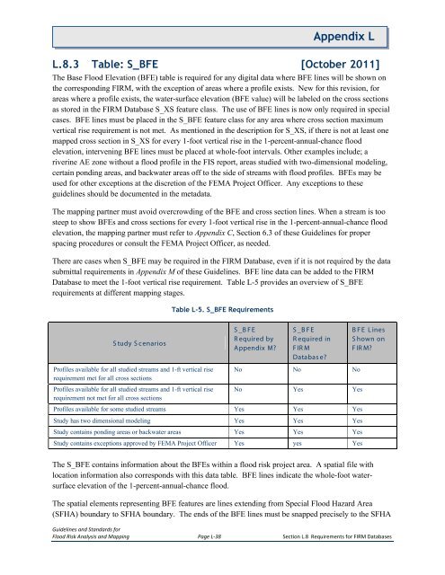
<strong>Appendix</strong> LL.8.3 Table: S_BFE [October 2011]The Base Flood Elevation (BFE) table is required for any digital data where BFE lines will be shown onthe corresponding FIRM, with the exception of areas where a profile exists. New for this revision, forareas where a profile exists, the water-surface elevation (BFE value) will be labeled on the cross sectionsas stored in the FIRM Database S_XS feature class. The use of BFE lines is now only required in specialcases. BFE lines must be placed in the S_BFE feature class for any area where cross section maximumvertical rise requirement is not met. As mentioned in the description for S_XS, if there is not at least onemapped cross section in S_XS for every 1-foot vertical rise in the 1-percent-annual-chance floodelevation, intervening BFE lines must be placed at whole-foot intervals. Other examples include; ariverine AE zone without a flood profile in the FIS report, areas studied with two-dimensional modeling,certain ponding areas, and backwater areas off to the side of streams with flood profiles. BFEs may beused for other exceptions at the discretion of the FEMA Project Officer. Any exceptions to theseguidelines should be documented in the metadata.The mapping partner must avoid overcrowding of the BFE and cross section lines. When a stream is toosteep to show BFEs and cross sections for every 1-foot vertical rise in the 1-percent-annual-chance floodelevation, the mapping partner must refer to <strong>Appendix</strong> C, Section 6.3 of these Guidelines for properspacing procedures or consult the FEMA Project Officer, as needed.There are cases when S_BFE may be required in the FIRM Database, even if it is not required by the datasubmittal requirements in <strong>Appendix</strong> M of these Guidelines. BFE line data can be added to the FIRMDatabase to meet the 1-foot vertical rise requirement. Table L-5 provides an overview of S_BFErequirements at different mapping stages.Table L-5. S_BFE RequirementsS tudy S cenariosS _B FER equired by<strong>Appendix</strong> M?S _B FER equired inFIR MDatabase?BFE L inesS hown onFIR M?Profiles available for all studied streams and 1-ft vertical riserequirement met for all cross sectionsProfiles available for all studied streams and 1-ft vertical riserequirement not met for all cross sectionsNo No NoNo Yes YesProfiles available for some studied streams Yes Yes YesStudy has two dimensional modeling Yes Yes YesStudy contains ponding areas or backwater areas Yes Yes YesStudy contains exceptions approved by FEMA Project Officer Yes yes YesThe S_BFE contains information about the BFEs within a flood risk project area. A spatial file withlocation information also corresponds with this data table. BFE lines indicate the whole-foot watersurfaceelevation of the 1-percent-annual-chance flood.The spatial elements representing BFE features are lines extending from Special Flood Hazard Area(SFHA) boundary to SFHA boundary. The ends of the BFE lines must be snapped precisely to the SFHAGuidelines and Standards forFlood Risk Analysis and Mapping Page L-38 Section L.8 Requirements for FIRM Databases


