

Appendix L - Federal Emergency Management Agency
Appendix L - Federal Emergency Management Agency
Appendix L - Federal Emergency Management Agency

Create successful ePaper yourself
Turn your PDF publications into a flip-book with our unique Google optimized e-Paper software.
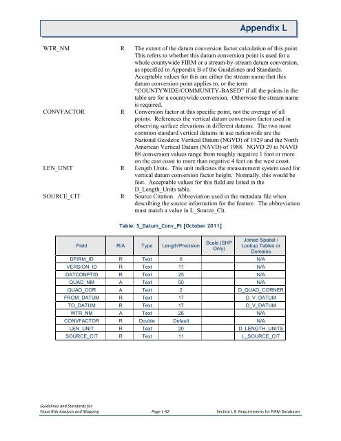
<strong>Appendix</strong> LWTR_NM R The extent of the datum conversion factor calculation of this point.This refers to whether this datum conversion point is used for awhole countywide FIRM or a stream-by-stream datum conversion,as specified in <strong>Appendix</strong> B of the Guidelines and Standards.Acceptable values for this are either the stream name that thisdatum conversion point applies to, or the term“COUNTYWIDE/COMMUNITY-BASED” if all the points in thetable are for a countywide conversion. Otherwise the stream nameis required.CONVFACTOR R Conversion factor at this specific point, not the average of allpoints. References the vertical datum conversion factor used inobserving surface elevations in different datums. The two mostcommon standard vertical datums in use nationwide are theNational Geodetic Vertical Datum (NGVD) of 1929 and the NorthAmerican Vertical Datum (NAVD) of 1988. NGVD 29 to NAVD88 conversion values range from roughly negative 1 foot or moreon the east coast to more than negative 4 feet on the west coast.LEN_UNIT R Length Units. This unit indicates the measurement system used forvertical datum conversion factor height. Normally, this would befeet. Acceptable values for this field are listed in theD_Length_Units table.SOURCE_CIT R Source Citation. Abbreviation used in the metadata file whendescribing the source information for the feature. The abbreviationmust match a value in L_Source_Cit.Table: S_Datum_Conv_Pt [October 2011]Field R/A Type Length/PrecisionScale (SHPOnly)Joined Spatial /Lookup Tables orDomainsDFIRM_ID R Text 6 N/AVERSION_ID R Text 11 N/ADATCONPTID R Text 25 N/AQUAD_NM A Text 50 N/AQUAD_COR A Text 2 D_QUAD_CORNERFROM_DATUM R Text 17 D_V_DATUMTO_DATUM R Text 17 D_V_DATUMWTR_NM A Text 26 N/ACONVFACTOR R Double Default N/ALEN_UNIT R Text 20 D_LENGTH_UNITSSOURCE_CIT R Text 11 L_SOURCE_CITGuidelines and Standards forFlood Risk Analysis and Mapping Page L-52 Section L.8 Requirements for FIRM Databases


