

Appendix L - Federal Emergency Management Agency
Appendix L - Federal Emergency Management Agency
Appendix L - Federal Emergency Management Agency

You also want an ePaper? Increase the reach of your titles
YUMPU automatically turns print PDFs into web optimized ePapers that Google loves.
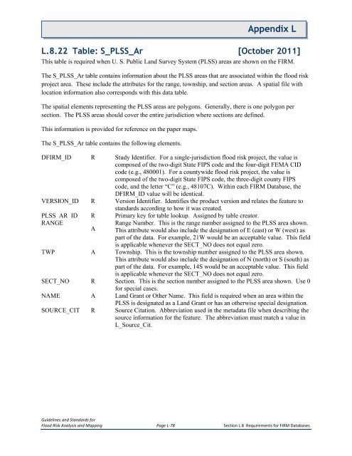
<strong>Appendix</strong> LL.8.22 Table: S_PLSS_Ar [October 2011]This table is required when U. S. Public Land Survey System (PLSS) areas are shown on the FIRM.The S_PLSS_Ar table contains information about the PLSS areas that are associated within the flood riskproject area. These include the attributes for the range, township, and section areas. A spatial file withlocation information also corresponds with this data table.The spatial elements representing the PLSS areas are polygons. Generally, there is one polygon persection. The PLSS areas should cover the entire jurisdiction where sections are defined.This information is provided for reference on the paper maps.The S_PLSS_Ar table contains the following elements.DFIRM_ID R Study Identifier. For a single-jurisdiction flood risk project, the value iscomposed of the two-digit State FIPS code and the four-digit FEMA CIDcode (e.g., 480001). For a countywide flood risk project, the value iscomposed of the two-digit State FIPS code, the three-digit county FIPScode, and the letter “C” (e.g., 48107C). Within each FIRM Database, theDFIRM_ID value will be identical.VERSION_ID R Version Identifier. Identifies the product version and relates the feature tostandards according to how it was created.PLSS_AR_ID R Primary key for table lookup. Assigned by table creator.RANGEARange Number. This is the range number assigned to the PLSS area shown.This attribute would also include the designation of E (east) or W (west) aspart of the data. For example, 21W would be an acceptable value. This fieldis applicable whenever the SECT_NO does not equal zero.TWP A Township. This is the township number assigned to the PLSS area shown.This attribute would also include the designation of N (north) or S (south) aspart of the data. For example, 14S would be an acceptable value. This fieldis applicable whenever the SECT_NO does not equal zero.SECT_NO R Section. This is the section number assigned to the PLSS area shown. Use 0for special cases.NAME A Land Grant or Other Name. This field is required when an area within thePLSS is designated as a Land Grant or has an otherwise special designation.SOURCE_CIT R Source Citation. Abbreviation used in the metadata file when describing thesource information for the feature. The abbreviation must match a value inL_Source_Cit.Guidelines and Standards forFlood Risk Analysis and Mapping Page L-78 Section L.8 Requirements for FIRM Databases


