

Appendix L - Federal Emergency Management Agency
Appendix L - Federal Emergency Management Agency
Appendix L - Federal Emergency Management Agency

Create successful ePaper yourself
Turn your PDF publications into a flip-book with our unique Google optimized e-Paper software.
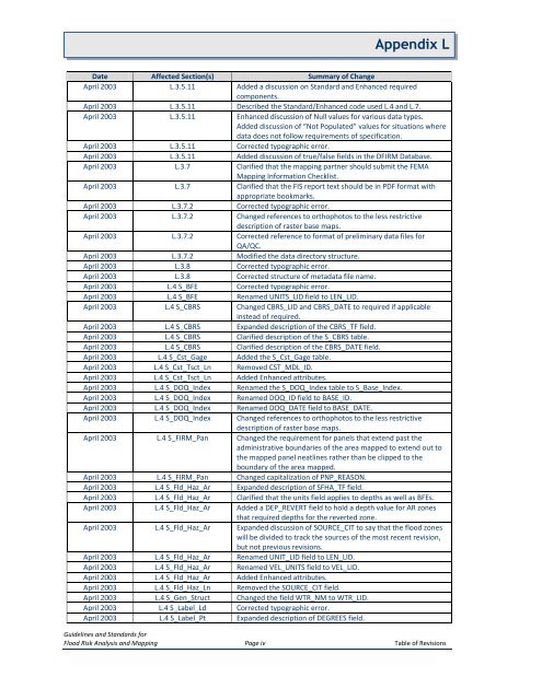
<strong>Appendix</strong> LDate Affected Section(s) Summary of ChangeApril 2003 L.3.5.11 Added a discussion on Standard and Enhanced requiredcomponents.April 2003 L.3.5.11 Described the Standard/Enhanced code used L.4 and L.7.April 2003 L.3.5.11 Enhanced discussion of Null values for various data types.Added discussion of “Not Populated” values for situations wheredata does not follow requirements of specification.April 2003 L.3.5.11 Corrected typographic error.April 2003 L.3.5.11 Added discussion of true/false fields in the DFIRM Database.April 2003 L.3.7 Clarified that the mapping partner should submit the FEMAMapping Information Checklist.April 2003 L.3.7 Clarified that the FIS report text should be in PDF format withappropriate bookmarks.April 2003 L.3.7.2 Corrected typographic error.April 2003 L.3.7.2 Changed references to orthophotos to the less restrictivedescription of raster base maps.April 2003 L.3.7.2 Corrected reference to format of preliminary data files forQA/QC.April 2003 L.3.7.2 Modified the data directory structure.April 2003 L.3.8 Corrected typographic error.April 2003 L.3.8 Corrected structure of metadata file name.April 2003 L.4 S_BFE Corrected typographic error.April 2003 L.4 S_BFE Renamed UNITS_LID field to LEN_LID.April 2003 L.4 S_CBRS Changed CBRS_LID and CBRS_DATE to required if applicableinstead of required.April 2003 L.4 S_CBRS Expanded description of the CBRS_TF field.April 2003 L.4 S_CBRS Clarified description of the S_CBRS table.April 2003 L.4 S_CBRS Clarified description of the CBRS_DATE field.April 2003 L.4 S_Cst_Gage Added the S_Cst_Gage table.April 2003 L.4 S_Cst_Tsct_Ln Removed CST_MDL_ID.April 2003 L.4 S_Cst_Tsct_Ln Added Enhanced attributes.April 2003 L.4 S_DOQ_Index Renamed the S_DOQ_Index table to S_Base_Index.April 2003 L.4 S_DOQ_Index Renamed DOQ_ID field to BASE_ID.April 2003 L.4 S_DOQ_Index Renamed DOQ_DATE field to BASE_DATE.April 2003 L.4 S_DOQ_Index Changed references to orthophotos to the less restrictivedescription of raster base maps.April 2003 L.4 S_FIRM_Pan Changed the requirement for panels that extend past theadministrative boundaries of the area mapped to extend out tothe mapped panel neatlines rather than be clipped to theboundary of the area mapped.April 2003 L.4 S_FIRM_Pan Changed capitalization of PNP_REASON.April 2003 L.4 S_Fld_Haz_Ar Expanded description of SFHA_TF field.April 2003 L.4 S_Fld_Haz_Ar Clarified that the units field applies to depths as well as BFEs.April 2003 L.4 S_Fld_Haz_Ar Added a DEP_REVERT field to hold a depth value for AR zonesthat required depths for the reverted zone.April 2003 L.4 S_Fld_Haz_Ar Expanded discussion of SOURCE_CIT to say that the flood zoneswill be divided to track the sources of the most recent revision,but not previous revisions.April 2003 L.4 S_Fld_Haz_Ar Renamed UNIT_LID field to LEN_LID.April 2003 L.4 S_Fld_Haz_Ar Renamed VEL_UNITS field to VEL_LID.April 2003 L.4 S_Fld_Haz_Ar Added Enhanced attributes.April 2003 L.4 S_Fld_Haz_Ln Removed the SOURCE_CIT field.April 2003 L.4 S_Gen_Struct Changed the field WTR_NM to WTR_LID.April 2003 L.4 S_Label_Ld Corrected typographic error.April 2003 L.4 S_Label_Pt Expanded description of DEGREES field.Guidelines and Standards forFlood Risk Analysis and Mapping Page iv Table of Revisions


