Appendix L - Federal Emergency Management Agency
Appendix L - Federal Emergency Management Agency
Appendix L - Federal Emergency Management Agency
You also want an ePaper? Increase the reach of your titles
YUMPU automatically turns print PDFs into web optimized ePapers that Google loves.
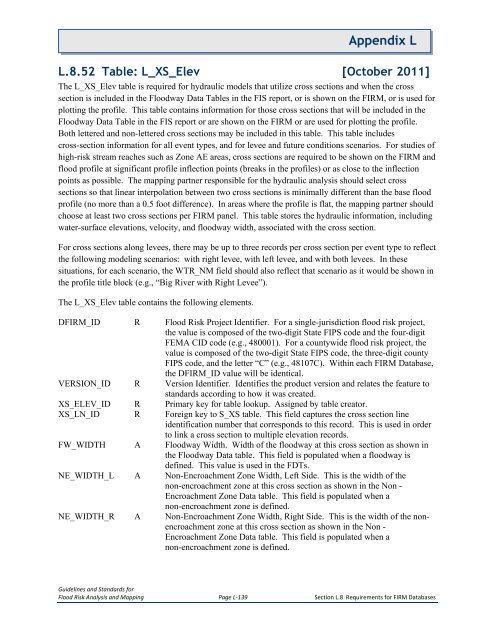
<strong>Appendix</strong> LL.8.52 Table: L_XS_Elev [October 2011]The L_XS_Elev table is required for hydraulic models that utilize cross sections and when the crosssection is included in the Floodway Data Tables in the FIS report, or is shown on the FIRM, or is used forplotting the profile. This table contains information for those cross sections that will be included in theFloodway Data Table in the FIS report or are shown on the FIRM or are used for plotting the profile.Both lettered and non-lettered cross sections may be included in this table. This table includescross-section information for all event types, and for levee and future conditions scenarios. For studies ofhigh-risk stream reaches such as Zone AE areas, cross sections are required to be shown on the FIRM andflood profile at significant profile inflection points (breaks in the profiles) or as close to the inflectionpoints as possible. The mapping partner responsible for the hydraulic analysis should select crosssections so that linear interpolation between two cross sections is minimally different than the base floodprofile (no more than a 0.5 foot difference). In areas where the profile is flat, the mapping partner shouldchoose at least two cross sections per FIRM panel. This table stores the hydraulic information, includingwater-surface elevations, velocity, and floodway width, associated with the cross section.For cross sections along levees, there may be up to three records per cross section per event type to reflectthe following modeling scenarios: with right levee, with left levee, and with both levees. In thesesituations, for each scenario, the WTR_NM field should also reflect that scenario as it would be shown inthe profile title block (e.g., “Big River with Right Levee”).The L_XS_Elev table contains the following elements.DFIRM_ID R Flood Risk Project Identifier. For a single-jurisdiction flood risk project,the value is composed of the two-digit State FIPS code and the four-digitFEMA CID code (e.g., 480001). For a countywide flood risk project, thevalue is composed of the two-digit State FIPS code, the three-digit countyFIPS code, and the letter “C” (e.g., 48107C). Within each FIRM Database,the DFIRM_ID value will be identical.VERSION_ID R Version Identifier. Identifies the product version and relates the feature tostandards according to how it was created.XS_ELEV_ID R Primary key for table lookup. Assigned by table creator.XS_LN_ID R Foreign key to S_XS table. This field captures the cross section lineidentification number that corresponds to this record. This is used in orderto link a cross section to multiple elevation records.FW_WIDTH A Floodway Width. Width of the floodway at this cross section as shown inthe Floodway Data table. This field is populated when a floodway isdefined. This value is used in the FDTs.NE_WIDTH_L A Non-Encroachment Zone Width, Left Side. This is the width of thenon-encroachment zone at this cross section as shown in the Non -Encroachment Zone Data table. This field is populated when anon-encroachment zone is defined.NE_WIDTH_R A Non-Encroachment Zone Width, Right Side. This is the width of the nonencroachmentzone at this cross section as shown in the Non -Encroachment Zone Data table. This field is populated when anon-encroachment zone is defined.Guidelines and Standards forFlood Risk Analysis and Mapping Page L-139 Section L.8 Requirements for FIRM Databases


