

Appendix L - Federal Emergency Management Agency
Appendix L - Federal Emergency Management Agency
Appendix L - Federal Emergency Management Agency

You also want an ePaper? Increase the reach of your titles
YUMPU automatically turns print PDFs into web optimized ePapers that Google loves.
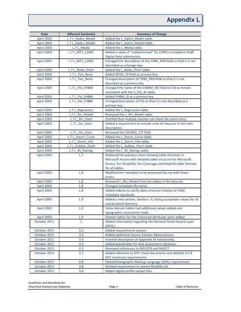
<strong>Appendix</strong> LDate Affected Section(s) Summary of ChangeApril 2003 L.7 L_Hydra_Model Added the L_Hydra_Model table.April 2003 L.7 L_Hydro_Model Added the L_Hydro_Model table.April 2003 L.7 L_Media Added the L_Media table.April 2003 L.7 L_MT1_LOMC Added a value of “redetermined” for LOMCs included in DraftDigital Data submissions.April 2003 L.7 L_MT1_LOMC Changed the description of the FIRM_PAN field so that it is notdescribed as a foreign key.April 2003 L.7 L_Node_Disch Added the L_Node_Disch table.April 2003 L.7 L_Pan_Revis Added REVIS_ID field as primary key.April 2003 L.7 L_Pan_Revis Changed description of FIRM_PAN field so that it is notdescribed as a primary key.April 2003 L.7 L_Pol_FHBM Changed the name of the COMM_NO field to CID to remainconsistent with the S_Pol_Ar table.April 2003 L.7 L_Pol_FHBM Added FHBM_ID as a primary key.April 2003 L.7 L_Pol_FHBM Changed description of CID so that it is not described as aprimary key.April 2003 L.7 L_Regression Added the L_Regression table.April 2003 L.7 L_Riv_Model Removed the L_Riv_Model table.April 2003 L.7 L_Stn_Start Clarified that multiple reaches can share the same entry.April 2003 L.7 L_Stn_Start Added a requirement to include units of measure in the startdescription.April 2003 L.7 L_Stn_Start Removed the SOURCE_CIT field.April 2003 L.7 L_Storm_Curve Added the L_Storm_Curve table.April 2003 L.7 L_Storm_Info Added the L_Storm_Info table.April 2003 L.7 L_Subbas_Disch Added the L_Subbas_Disch table.April 2003 L.7 L_XS_Ratings Added the L_XS_Ratings table.April 2003 L.7 Replaced the previous chart showing table structure inMicrosoft Access with detailed table structure for MicrosoftAccess, Esri Shapefile, Esri Coverage and MapInfo table formatsfor all tables.April 2003 L.8 Modified the metadata to be processed by mp with fewererrors.April 2003 L.8 Removed L_Riv_Model from the tables in the data set.April 2003 L.8 Changed metadata file name.April 2003 L.8 Added indents to clarify data structure relative to FGDCmetadata standards.April 2003 L.9 Added a new section, Section L.9, listing acceptable values for allstandardized domains.April 2003 L.9 Some domain tables had additional values added andtypographic corrections made.April 2003 L.9 Domain tables for the Enhanced attributes were added.October 2011 1 Added information regarding the National Flood Hazard Layer(NFHL).October 2011 3.2 Added requirements section.October 2011 3.3 Added additional Source Citation Abbreviations.October 2011 3.4 Inserted description of <strong>Appendix</strong> M relationship.October 2011 3.4 Added placeholder for Risk Assessment database.October 2011 3.5 Removed references to NGVD29 and NAD27.October 2011 3.7 Added reference to DVT check documents and deleted 3.5.8DVT minimum requirements.October 2011 3.8 Deleted Geographic Markup Language (GML) requirement.October 2011 3.8 Deleted requirement to submit ReadMe.txt.October 2011 3.8 Added digital profile output files.Guidelines and Standards forFlood Risk Analysis and Mapping Page x Table of Revisions


