

Appendix L - Federal Emergency Management Agency
Appendix L - Federal Emergency Management Agency
Appendix L - Federal Emergency Management Agency

You also want an ePaper? Increase the reach of your titles
YUMPU automatically turns print PDFs into web optimized ePapers that Google loves.
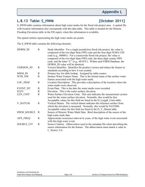
<strong>Appendix</strong> LL.8.13 Table: S_HWM [October 2011]S_HWM table contains information about high water marks for the flood risk project area. A spatial filewith location information also corresponds with this data table. This table is needed for the HistoricFlooding Elevations table in the FIS report, when this information is available.The spatial entities representing the high water marks are points.The S_HWM table contains the following elements.DFIRM_ID R Study Identifier. For a single-jurisdiction flood risk project, the value iscomposed of the two-digit State FIPS code and the four-digit FEMA CIDcode (e.g., 480001). For a countywide flood risk project, the value iscomposed of the two-digit State FIPS code, the three-digit county FIPScode, and the letter “C” (e.g., 48107C). Within each FIRM Database, theDFIRM_ID value will be identical.VERSION_ID R Version Identifier. Identifies the product version and relates the feature tostandards according to how it was created.HWM_ID R Primary key for table lookup. Assigned by table creator.WTR_NM R Surface Water Feature Name. This is the formal name of the surface waterfeature associated with the high water mark.LOC_DESC R Location Description. This provides a description of the location where thewater marks were observed.EVENT_DT R Event Date. This is the date the water marks were recorded.ELEV R Elevation. This is the water-surface elevation.LEN_UNIT R Water-Surface Elevation Units. This unit indicates the measurement systemused for the water-surface elevation. Normally, this would be feet.Acceptable values for this field are listed in the D_Length_Units table.V_DATUM R Vertical Datum. The vertical datum indicates the reference surface fromwhich the elevation is measured. Normally, this would be NAVD88.Acceptable values for this field are listed in the D_V_Datum table.HWM_SOURCE RSource of Historic Water Mark Data. Brief description of the source of thehigh water mark data.APX_FREQ R Approximate recurrence interval in years, of the high water event associatedwith this high water event.SOURCE_CIT R Source Citation. Abbreviation used in the metadata file when describing thesource information for the feature. The abbreviation must match a value inL_Source_Cit.Guidelines and Standards forFlood Risk Analysis and Mapping Page L-63 Section L.8 Requirements for FIRM Databases


