

Appendix L - Federal Emergency Management Agency
Appendix L - Federal Emergency Management Agency
Appendix L - Federal Emergency Management Agency

You also want an ePaper? Increase the reach of your titles
YUMPU automatically turns print PDFs into web optimized ePapers that Google loves.
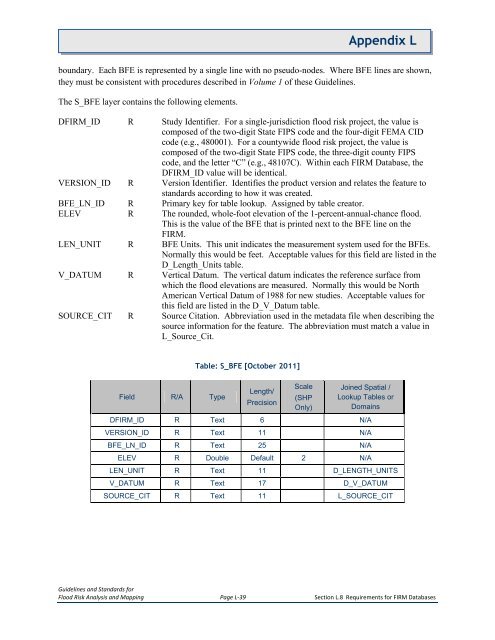
<strong>Appendix</strong> Lboundary. Each BFE is represented by a single line with no pseudo-nodes. Where BFE lines are shown,they must be consistent with procedures described in Volume 1 of these Guidelines.The S_BFE layer contains the following elements.DFIRM_ID R Study Identifier. For a single-jurisdiction flood risk project, the value iscomposed of the two-digit State FIPS code and the four-digit FEMA CIDcode (e.g., 480001). For a countywide flood risk project, the value iscomposed of the two-digit State FIPS code, the three-digit county FIPScode, and the letter “C” (e.g., 48107C). Within each FIRM Database, theDFIRM_ID value will be identical.VERSION_ID R Version Identifier. Identifies the product version and relates the feature tostandards according to how it was created.BFE_LN_ID R Primary key for table lookup. Assigned by table creator.ELEV R The rounded, whole-foot elevation of the 1-percent-annual-chance flood.This is the value of the BFE that is printed next to the BFE line on theFIRM.LEN_UNIT R BFE Units. This unit indicates the measurement system used for the BFEs.Normally this would be feet. Acceptable values for this field are listed in theD_Length_Units table.V_DATUM R Vertical Datum. The vertical datum indicates the reference surface fromwhich the flood elevations are measured. Normally this would be NorthAmerican Vertical Datum of 1988 for new studies. Acceptable values forthis field are listed in the D_V_Datum table.SOURCE_CIT R Source Citation. Abbreviation used in the metadata file when describing thesource information for the feature. The abbreviation must match a value inL_Source_Cit.Field R/A TypeTable: S_BFE [October 2011]Length/PrecisionScale(SHPOnly)Joined Spatial /Lookup Tables orDomainsDFIRM_ID R Text 6 N/AVERSION_ID R Text 11 N/ABFE_LN_ID R Text 25 N/AELEV R Double Default 2 N/ALEN_UNIT R Text 11 D_LENGTH_UNITSV_DATUM R Text 17 D_V_DATUMSOURCE_CIT R Text 11 L_SOURCE_CITGuidelines and Standards forFlood Risk Analysis and Mapping Page L-39 Section L.8 Requirements for FIRM Databases


