Appendix L - Federal Emergency Management Agency
Appendix L - Federal Emergency Management Agency
Appendix L - Federal Emergency Management Agency
You also want an ePaper? Increase the reach of your titles
YUMPU automatically turns print PDFs into web optimized ePapers that Google loves.
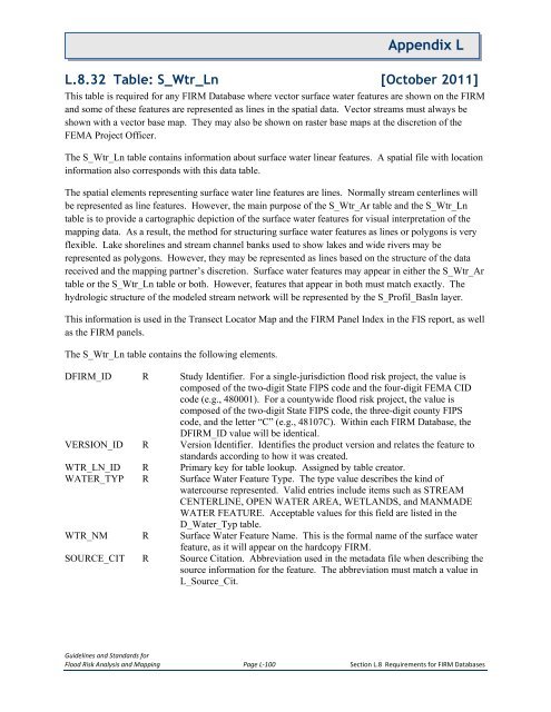
<strong>Appendix</strong> LL.8.32 Table: S_Wtr_Ln [October 2011]This table is required for any FIRM Database where vector surface water features are shown on the FIRMand some of these features are represented as lines in the spatial data. Vector streams must always beshown with a vector base map. They may also be shown on raster base maps at the discretion of theFEMA Project Officer.The S_Wtr_Ln table contains information about surface water linear features. A spatial file with locationinformation also corresponds with this data table.The spatial elements representing surface water line features are lines. Normally stream centerlines willbe represented as line features. However, the main purpose of the S_Wtr_Ar table and the S_Wtr_Lntable is to provide a cartographic depiction of the surface water features for visual interpretation of themapping data. As a result, the method for structuring surface water features as lines or polygons is veryflexible. Lake shorelines and stream channel banks used to show lakes and wide rivers may berepresented as polygons. However, they may be represented as lines based on the structure of the datareceived and the mapping partner’s discretion. Surface water features may appear in either the S_Wtr_Artable or the S_Wtr_Ln table or both. However, features that appear in both must match exactly. Thehydrologic structure of the modeled stream network will be represented by the S_Profil_Basln layer.This information is used in the Transect Locator Map and the FIRM Panel Index in the FIS report, as wellas the FIRM panels.The S_Wtr_Ln table contains the following elements.DFIRM_ID R Study Identifier. For a single-jurisdiction flood risk project, the value iscomposed of the two-digit State FIPS code and the four-digit FEMA CIDcode (e.g., 480001). For a countywide flood risk project, the value iscomposed of the two-digit State FIPS code, the three-digit county FIPScode, and the letter “C” (e.g., 48107C). Within each FIRM Database, theDFIRM_ID value will be identical.VERSION_ID R Version Identifier. Identifies the product version and relates the feature tostandards according to how it was created.WTR_LN_ID R Primary key for table lookup. Assigned by table creator.WATER_TYP R Surface Water Feature Type. The type value describes the kind ofwatercourse represented. Valid entries include items such as STREAMCENTERLINE, OPEN WATER AREA, WETLANDS, and MANMADEWATER FEATURE. Acceptable values for this field are listed in theD_Water_Typ table.WTR_NM R Surface Water Feature Name. This is the formal name of the surface waterfeature, as it will appear on the hardcopy FIRM.SOURCE_CIT R Source Citation. Abbreviation used in the metadata file when describing thesource information for the feature. The abbreviation must match a value inL_Source_Cit.Guidelines and Standards forFlood Risk Analysis and Mapping Page L-100 Section L.8 Requirements for FIRM Databases


