

Appendix L - Federal Emergency Management Agency
Appendix L - Federal Emergency Management Agency
Appendix L - Federal Emergency Management Agency

Create successful ePaper yourself
Turn your PDF publications into a flip-book with our unique Google optimized e-Paper software.
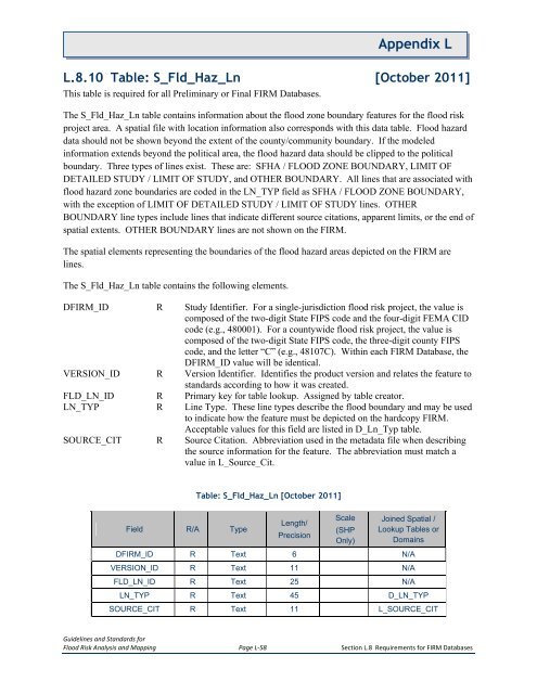
<strong>Appendix</strong> LL.8.10 Table: S_Fld_Haz_Ln [October 2011]This table is required for all Preliminary or Final FIRM Databases.The S_Fld_Haz_Ln table contains information about the flood zone boundary features for the flood riskproject area. A spatial file with location information also corresponds with this data table. Flood hazarddata should not be shown beyond the extent of the county/community boundary. If the modeledinformation extends beyond the political area, the flood hazard data should be clipped to the politicalboundary. Three types of lines exist. These are: SFHA / FLOOD ZONE BOUNDARY, LIMIT OFDETAILED STUDY / LIMIT OF STUDY, and OTHER BOUNDARY. All lines that are associated withflood hazard zone boundaries are coded in the LN_TYP field as SFHA / FLOOD ZONE BOUNDARY,with the exception of LIMIT OF DETAILED STUDY / LIMIT OF STUDY lines. OTHERBOUNDARY line types include lines that indicate different source citations, apparent limits, or the end ofspatial extents. OTHER BOUNDARY lines are not shown on the FIRM.The spatial elements representing the boundaries of the flood hazard areas depicted on the FIRM arelines.The S_Fld_Haz_Ln table contains the following elements.DFIRM_ID R Study Identifier. For a single-jurisdiction flood risk project, the value iscomposed of the two-digit State FIPS code and the four-digit FEMA CIDcode (e.g., 480001). For a countywide flood risk project, the value iscomposed of the two-digit State FIPS code, the three-digit county FIPScode, and the letter “C” (e.g., 48107C). Within each FIRM Database, theDFIRM_ID value will be identical.VERSION_ID R Version Identifier. Identifies the product version and relates the feature tostandards according to how it was created.FLD_LN_ID R Primary key for table lookup. Assigned by table creator.LN_TYP R Line Type. These line types describe the flood boundary and may be usedto indicate how the feature must be depicted on the hardcopy FIRM.Acceptable values for this field are listed in D_Ln_Typ table.SOURCE_CIT R Source Citation. Abbreviation used in the metadata file when describingthe source information for the feature. The abbreviation must match avalue in L_Source_Cit.Table: S_Fld_Haz_Ln [October 2011]Field R/A TypeLength/PrecisionScale(SHPOnly)Joined Spatial /Lookup Tables orDomainsDFIRM_ID R Text 6 N/AVERSION_ID R Text 11 N/AFLD_LN_ID R Text 25 N/ALN_TYP R Text 45 D_LN_TYPSOURCE_CIT R Text 11 L_SOURCE_CITGuidelines and Standards forFlood Risk Analysis and Mapping Page L-58 Section L.8 Requirements for FIRM Databases


