Appendix L - Federal Emergency Management Agency
Appendix L - Federal Emergency Management Agency
Appendix L - Federal Emergency Management Agency
Create successful ePaper yourself
Turn your PDF publications into a flip-book with our unique Google optimized e-Paper software.
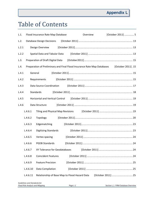
<strong>Appendix</strong> LTable of ContentsL.1. Flood Insurance Rate Map Database Overview [October 2011] .............. 5L.2. Database Design Decisions [October 2011] .............................................................................. 13L.2.1 Design Overview [October 2011] ................................................................................... 13L.2.2 Spatial Data and Tabular Data [October 2011] ................................................................ 13L.3. Preparation of Draft Digital Data [October2011]...................................................................... 15L.4. Preparation of Preliminary and Final Flood Insurance Rate Map Databases [October 2011] . 15L.4.1 General [October 2011] ............................................................................................ 15L.4.2 Requirements [October 2011] ..................................................................................... 15L.4.3 Data Source Coordination [October 2011] ..................................................................... 17L.4.4 Standards [October 2011] .......................................................................................... 18L.4.5 Horizontal and Vertical Control [October 2011] ................................................................ 19L.4.6 Data Structure [October 2011] .................................................................................... 19L.4.6.1 Tiling and Physical Map Revisions [October 2011] ................................................ 19L.4.6.2 Topology [October 2011] ................................................................................... 20L.4.6.3 Edgematching [October 2011] .......................................................................... 23L.4.6.4 Digitizing Standards [October 2011] ................................................................. 23L.4.6.5 Vertex spacing [October 2011] ....................................................................... 24L.4.6.6 PGDB Standards [October 2011] ........................................................................ 24L.4.6.7 XY Tolerance for Geodatabases [October 2011] ................................................. 24L.4.6.8 Coincident Features [October 2011] .................................................................. 24L.4.6.9 Feature Precision [October 2011] ...................................................................... 25L.4.6.10 Data Compilation [October 2011] ................................................................... 25L.4.6.11 Relationship of Base Map to Flood Hazard Data [October 2011] .............................. 25Guidelines and Standards forFlood Risk Analysis and Mapping Page L-1 Section L.1 FIRM Database Overview


