


You also want an ePaper? Increase the reach of your titles
YUMPU automatically turns print PDFs into web optimized ePapers that Google loves.
FOCUS<br />
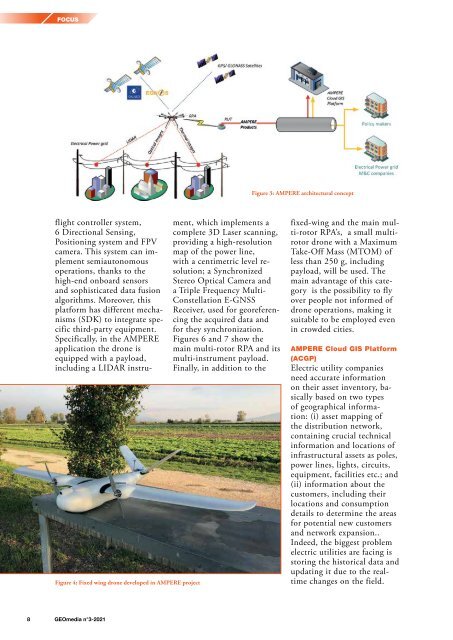
Figure 3: AMPERE architectural concept<br />
Figure 4: Fixed wing drone developed in AMPERE project<br />
flight controller system,<br />
6 Directional Sensing,<br />
Positioning system and FPV<br />
camera. This system can implement<br />
semiautonomous<br />
operations, thanks to the<br />
high-end onboard sensors<br />
and sophisticated data fusion<br />
algorithms. Moreover, this<br />
platform has different mechanisms<br />
(SDK) to integrate specific<br />
third-party equipment.<br />
Specifically, in the AMPERE<br />
application the drone is<br />
equipped with a payload,<br />
including a LIDAR instrument,<br />
which implements a<br />
complete 3D Laser scanning,<br />
providing a high-resolution<br />
map of the power line,<br />
with a centimetric level resolution;<br />
a Synchronized<br />
Stereo Optical Camera and<br />
a Triple Frequency Multi-<br />
Constellation E-GNSS<br />
Receiver, used for georeferencing<br />
the acquired data and<br />
for they synchronization.<br />
Figures 6 and 7 show the<br />
main multi-rotor RPA and its<br />
multi-instrument payload.<br />
Finally, in addition to the<br />
fixed-wing and the main multi-rotor<br />
RPA’s, a small multirotor<br />
drone with a Maximum<br />
Take-Off Mass (MTOM) of<br />
less than 250 g, including<br />
payload, will be used. The<br />
main advantage of this category<br />
is the possibility to fly<br />
over people not informed of<br />
drone operations, making it<br />
suitable to be employed even<br />
in crowded cities.<br />
AMPERE Cloud GIS Platform<br />
(ACGP)<br />
Electric utility companies<br />
need accurate information<br />
on their asset inventory, basically<br />
based on two types<br />
of geographical information:<br />
(i) asset mapping of<br />
the distribution network,<br />
containing crucial technical<br />
information and locations of<br />
infrastructural assets as poles,<br />
power lines, lights, circuits,<br />
equipment, facilities etc.; and<br />
(ii) information about the<br />
customers, including their<br />
locations and consumption<br />
details to determine the areas<br />
for potential new customers<br />
and network expansion..<br />
Indeed, the biggest problem<br />
electric utilities are facing is<br />
storing the historical data and<br />
updating it due to the realtime<br />
changes on the field.<br />
8 <strong>GEOmedia</strong> n°3-<strong>2021</strong>


