

Bogue Banks Beach - Carteret County Shore Protection Office
Bogue Banks Beach - Carteret County Shore Protection Office
Bogue Banks Beach - Carteret County Shore Protection Office

You also want an ePaper? Increase the reach of your titles
YUMPU automatically turns print PDFs into web optimized ePapers that Google loves.
Final Report <strong>Bogue</strong> <strong>Banks</strong> <strong>Beach</strong> & Nearshore Mapping Program<br />
Periodic Survey Evaluation<br />
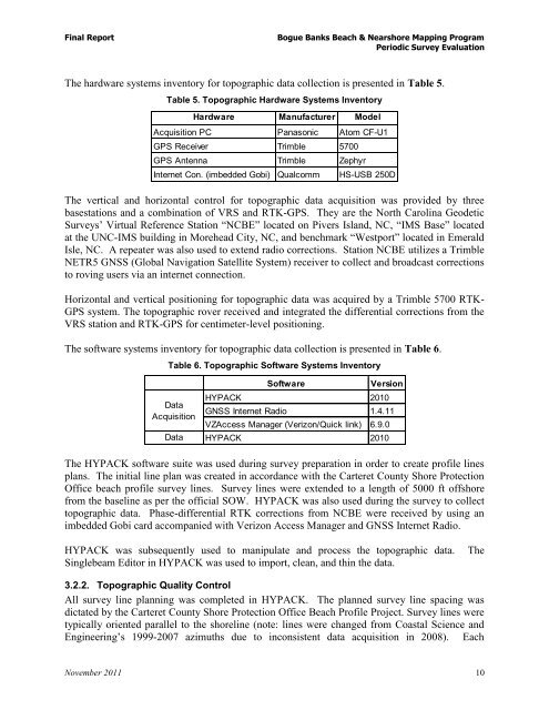
The hardware systems inventory for topographic data collection is presented in Table 5.<br />
Table 5. Topographic Hardware Systems Inventory<br />
Hardware Manufacturer Model<br />
Acquisition PC Panasonic Atom CF-U1<br />
GPS Receiver Trimble 5700<br />
GPS Antenna Trimble Zephyr<br />
Internet Con. (imbedded Gobi) Qualcomm HS-USB 250D<br />
The vertical and horizontal control for topographic data acquisition was provided by three<br />
basestations and a combination of VRS and RTK-GPS. They are the North Carolina Geodetic<br />
Surveys’ Virtual Reference Station “NCBE” located on Pivers Island, NC, “IMS Base” located<br />
at the UNC-IMS building in Morehead City, NC, and benchmark “Westport” located in Emerald<br />
Isle, NC. A repeater was also used to extend radio corrections. Station NCBE utilizes a Trimble<br />
NETR5 GNSS (Global Navigation Satellite System) receiver to collect and broadcast corrections<br />
to roving users via an internet connection.<br />
Horizontal and vertical positioning for topographic data was acquired by a Trimble 5700 RTK-<br />
GPS system. The topographic rover received and integrated the differential corrections from the<br />
VRS station and RTK-GPS for centimeter-level positioning.<br />
The software systems inventory for topographic data collection is presented in Table 6.<br />
Table 6. Topographic Software Systems Inventory<br />
Data<br />
Acquisition<br />
Data<br />
Processing<br />
Software Version<br />
HYPACK 2010<br />
GNSS Internet Radio 1.4.11<br />
VZAccess Manager (Verizon/Quick link) 6.9.0<br />
HYPACK 2010<br />
The HYPACK software suite was used during survey preparation in order to create profile lines<br />
plans. The initial line plan was created in accordance with the <strong>Carteret</strong> <strong>County</strong> <strong>Shore</strong> <strong>Protection</strong><br />
<strong>Office</strong> beach profile survey lines. Survey lines were extended to a length of 5000 ft offshore<br />
from the baseline as per the official SOW. HYPACK was also used during the survey to collect<br />
topographic data. Phase-differential RTK corrections from NCBE were received by using an<br />
imbedded Gobi card accompanied with Verizon Access Manager and GNSS Internet Radio.<br />
HYPACK was subsequently used to manipulate and process the topographic data. The<br />
Singlebeam Editor in HYPACK was used to import, clean, and thin the data.<br />
3.2.2. Topographic Quality Control<br />
All survey line planning was completed in HYPACK. The planned survey line spacing was<br />
dictated by the <strong>Carteret</strong> <strong>County</strong> <strong>Shore</strong> <strong>Protection</strong> <strong>Office</strong> <strong>Beach</strong> Profile Project. Survey lines were<br />
typically oriented parallel to the shoreline (note: lines were changed from Coastal Science and<br />
Engineering’s 1999-2007 azimuths due to inconsistent data acquisition in 2008). Each<br />
November 2011 10