

Bogue Banks Beach - Carteret County Shore Protection Office
Bogue Banks Beach - Carteret County Shore Protection Office
Bogue Banks Beach - Carteret County Shore Protection Office

You also want an ePaper? Increase the reach of your titles
YUMPU automatically turns print PDFs into web optimized ePapers that Google loves.
Final Report <strong>Bogue</strong> <strong>Banks</strong> <strong>Beach</strong> & Nearshore Mapping Program<br />
Periodic Survey Evaluation<br />
Executive Summary<br />
Comprehensive surveying of the <strong>Bogue</strong> <strong>Banks</strong> shoreline began in 1999 to develop the <strong>Bogue</strong><br />
<strong>Banks</strong> <strong>Beach</strong> Restoration Project. In Spring 2004, the <strong>Bogue</strong> <strong>Banks</strong> <strong>Beach</strong> and Nearshore<br />
Mapping Program was initiated to assess beach conditions and form strategies for future<br />
beach nourishment projects. Bear Island was added to the program in October 2004 and<br />
Shackleford <strong>Banks</strong> was added in May 2005. Currently, surveys are performed annually<br />
during each spring/summer timeframe along all three islands. In addition, after large storm<br />
events surveying is performed along <strong>Bogue</strong> <strong>Banks</strong> to assess damages. The most recent<br />
regular survey was completed during spring and summer 2011 (May and June 2011) by<br />
Geodynamics. For this evaluation, the spring/summer 2011 survey was compared with the<br />
spring/summer 2010 (April and June 2010) survey. The survey data was used to compute<br />
shoreline change at +1.1 ft NAVD88 which is designated as Mean High Water (MHW) and<br />
volume change above MHW, -5 ft NAVD88 (wading depth), -12 ft NAVD88 (outer bar), -20<br />
ft NAVD88, and -30 ft NAVD88.<br />
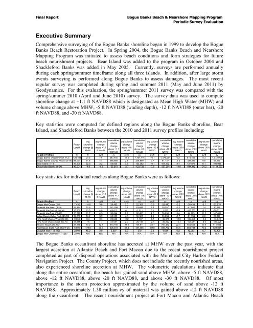
Key statistics were computed for defined regions along the <strong>Bogue</strong> <strong>Banks</strong> shoreline, Bear<br />
Island, and Shackleford <strong>Banks</strong> between the 2010 and 2011 survey profiles including;<br />
Reach<br />
Length<br />
avg<br />
shoreline<br />
change @<br />
MHW<br />
avg volume<br />
change<br />
above +1.1<br />
ft NAVD<br />
cumulative<br />
volume<br />
change<br />
above +1.1<br />
ft NAVD<br />
avg volume<br />
change<br />
above -5 ft<br />
NAVD<br />
cumulative<br />
volume<br />
change<br />
above -5 ft<br />
Key statistics for individual reaches along <strong>Bogue</strong> <strong>Banks</strong> were as follows:<br />
The <strong>Bogue</strong> <strong>Banks</strong> oceanfront shoreline has accreted at MHW over the past year, with the<br />
largest accretion at Atlantic <strong>Beach</strong> and Fort Macon due to the recent nourishment project<br />
completed as part of disposal operations associated with the Morehead City Harbor Federal<br />
Navigation Project. The <strong>County</strong> Project, which does not include the recently nourished areas,<br />
also experienced shoreline accretion at MHW. The volumetric calculations indicate that<br />
along the entire oceanfront, the beach has gained sand above MHW, above -5 ft NAVD88,<br />
above -12 ft NAVD88, above -20 ft NAVD88, and above -30 ft NAVD88. Of most<br />
importance is the storm protection approximated by the volume of sand above -12 ft<br />
NAVD88. Approximately 1.38 million cy of material was gained above -12 ft NAVD88<br />
along the oceanfront. The recent nourishment project at Fort Macon and Atlantic <strong>Beach</strong><br />
NAVD<br />
avg volume<br />
change<br />
above -12 ft<br />
NAVD<br />
cumulative<br />
volume<br />
change<br />
above -12 ft<br />
NAVD<br />
avg volume<br />
change<br />
above -20 ft<br />
NAVD<br />
cumulative<br />
volume<br />
change<br />
above -20 ft<br />
NAVD<br />
avg volume<br />
change<br />
above -30 ft<br />
NAVD<br />
cumulative<br />
volume<br />
change<br />
above -30 ft<br />
NAVD<br />
Reach (Profiles) ft ft cy/ft cy cy/ft cy cy/ft cy cy/ft cy cy/ft cy<br />
<strong>Bogue</strong> <strong>Banks</strong> Oceanfront (1-112) 128,393 27.3 7.5 957,480 11.4 1,461,416 10.7 1,378,951 5.2 673,345 8.3 1,072,063<br />
<strong>Bogue</strong> <strong>Banks</strong> <strong>County</strong> Project (9-76) 88,094 11.6 4.4 388,666 2.8 245,899 0.7 61,137 -5.0 -437,610 0.6 54,170<br />
Bear Island (1-18) 16,500 22.3 3.2 53,005 7.5 123,382 10.1 167,132 8.4 137,875 6.1 100,963<br />
Shackleford <strong>Banks</strong> (1-24) 46,001 -4.9 -1.2 -56,018 -2.7 -123,728 -7.8 -357,204 -14.0 -644,412 -24.2 -1,114,569<br />
Reach<br />
Length<br />
avg<br />
shoreline<br />
change @<br />
MHW<br />
avg volume<br />
change<br />
above +1.1<br />
ft NAVD<br />
cumulative<br />
volume<br />
change<br />
above +1.1<br />
ft NAVD<br />
avg volume<br />
change<br />
above -5 ft<br />
NAVD<br />
cumulative<br />
volume<br />
change<br />
above -5 ft<br />
NAVD<br />
avg volume<br />
change<br />
above -12 ft<br />
NAVD<br />
cumulative<br />
volume<br />
change<br />
above -12 ft<br />
NAVD<br />
avg volume<br />
change<br />
above -20 ft<br />
NAVD<br />
cumulative<br />
volume<br />
change<br />
above -20 ft<br />
NAVD<br />
avg volume<br />
change<br />
above -30 ft<br />
NAVD<br />
cumulative<br />
volume<br />
change<br />
above -30 ft<br />
NAVD<br />
Reach (Profiles) ft ft cy/ft cy cy/ft cy cy/ft cy cy/ft cy cy/ft cy<br />
<strong>Bogue</strong> Inlet-Ocean (1-8) 7,432 -14.8 3.8 28,493 3.0 22,301 -3.8 -28,440 -5.2 -38,433 -3.1 -22,978<br />
Emerald Isle-West (9-25) 22,344 12.9 7.2 161,299 3.7 83,684 1.4 30,257 -2.1 -47,502 1.4 30,879<br />
Emerald Isle-Central (26-36) 15,802 13.5 4.0 63,613 -0.1 -1,011 0.1 1,206 -6.8 -106,753 -3.2 -50,571<br />
Emerald Isle-East (37-48) 13,220 11.7 4.5 58,844 6.1 80,428 4.2 56,038 3.4 44,925 11.2 147,689<br />
Indian <strong>Beach</strong>-Salter Path (49-58) 12,850 14.2 3.9 50,509 4.3 55,361 4.3 55,234 -1.7 -21,734 6.8 87,177<br />
Pine Knoll <strong>Shore</strong>s-West (59-65) 9,063 8.3 3.3 29,850 -0.2 -1,707 -5.1 -46,374 -12.0 -108,635 -4.8 -43,078<br />
Pine Knoll <strong>Shore</strong>s-East (66-76) 14,815 7.5 1.7 24,551 2.0 29,145 -2.4 -35,222 -13.4 -197,911 -8.0 -117,926<br />
Atlantic <strong>Beach</strong> (77-102) 26,176 53.2 12.8 333,780 28.1 735,811 28.7 750,462 22.3 584,654 19.5 511,064<br />
Fort Macon State Park (103-112) 6,691 179.0 30.9 206,541 68.4 457,405 89.0 595,792 84.4 564,734 79.2 529,807<br />
Beaufort Inlet (113-116) 2,000 45.0 3.0 5,997 0.2 378 2.3 4,631 6.2 12,383 6.7 13,409<br />
<strong>Bogue</strong> Inlet-Channel (117-120)* 2,000 N/A N/A N/A N/A N/A N/A N/A N/A N/A N/A N/A