

Bogue Banks Beach - Carteret County Shore Protection Office
Bogue Banks Beach - Carteret County Shore Protection Office
Bogue Banks Beach - Carteret County Shore Protection Office

Create successful ePaper yourself
Turn your PDF publications into a flip-book with our unique Google optimized e-Paper software.
Final Report <strong>Bogue</strong> <strong>Banks</strong> <strong>Beach</strong> & Nearshore Mapping Program<br />
Periodic Survey Evaluation<br />
Mean Volume Change (cy/ft)<br />
Mean Volume Change (cy/ft)<br />
80<br />
70<br />
60<br />
50<br />
40<br />
30<br />
20<br />
10<br />
0<br />
-10<br />
-20<br />
-30<br />
-40<br />
-50<br />
-60<br />
-70<br />
-80<br />
80<br />
70<br />
60<br />
50<br />
40<br />
30<br />
20<br />
10<br />
0<br />
-10<br />
-20<br />
-30<br />
-40<br />
-50<br />
-60<br />
-70<br />
<strong>Bogue</strong><br />
Inlet<br />
Ocean<br />
-129<br />
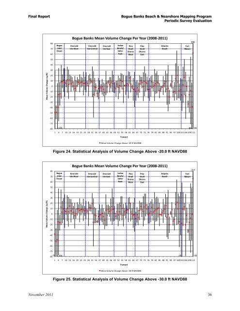
<strong>Bogue</strong> <strong>Banks</strong> Mean Volume Change Per Year (2008-2011)<br />
Emerald<br />
Isle West<br />
Emerald<br />
Isle Central<br />
Emerald<br />
Isle East<br />
Indian<br />
<strong>Beach</strong>/<br />
Salter<br />
Path<br />
1 4 7 10 13 16 19 22 25 28 31 34 37 40 43 46 49 52 55 58 61 64 67 70 73 76 79 82 85 88 91 94 97 100103106109112<br />
Figure 24. Statistical Analysis of Volume Change Above -20.0 ft NAVD88<br />
<strong>Bogue</strong><br />
Inlet<br />
Ocean<br />
Figure 25. Statistical Analysis of Volume Change Above -30.0 ft NAVD88<br />
November 2011 36<br />
Transect<br />
Pine<br />
Knoll<br />
<strong>Shore</strong>s<br />
West<br />
Mean Volume Change Above -20 ft NAVD88<br />
Pine<br />
Knoll<br />
<strong>Shore</strong>s<br />
East<br />
Atlantic<br />
<strong>Beach</strong><br />
<strong>Bogue</strong> <strong>Banks</strong> Mean Volume Change Per Year (2008-2011)<br />
Emerald<br />
Isle West<br />
Emerald<br />
Isle Central<br />
Emerald<br />
Isle East<br />
Indian<br />
<strong>Beach</strong>/<br />
Salter<br />
Path<br />
Fort<br />
Macon<br />
-143<br />
-80 -104 -95<br />
-85<br />
1 4 7 10 13 16 19 22 25 28 31 34 37 40 43 46 49 52 55 58 61 64 67 70 73 76 79 82 85 88 91 94 97 100103106109112<br />
Transect<br />
Pine<br />
Knoll<br />
<strong>Shore</strong>s<br />
West<br />
Mean Volume Change Above -30 ft NAVD88<br />
Pine<br />
Knoll<br />
<strong>Shore</strong>s<br />
East<br />
Atlantic<br />
<strong>Beach</strong><br />
-84<br />
Fort<br />
Macon<br />
208<br />
217<br />
-84