

Bogue Banks Beach - Carteret County Shore Protection Office
Bogue Banks Beach - Carteret County Shore Protection Office
Bogue Banks Beach - Carteret County Shore Protection Office

Create successful ePaper yourself
Turn your PDF publications into a flip-book with our unique Google optimized e-Paper software.
Final Report <strong>Bogue</strong> <strong>Banks</strong> <strong>Beach</strong> & Nearshore Mapping Program<br />
Periodic Survey Evaluation<br />
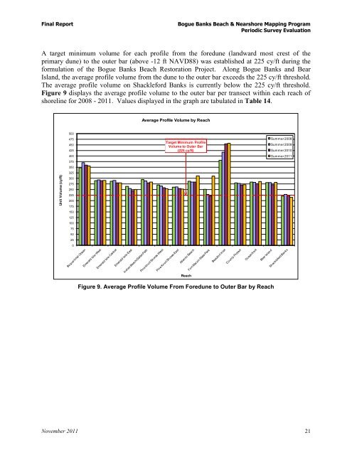
A target minimum volume for each profile from the foredune (landward most crest of the<br />
primary dune) to the outer bar (above -12 ft NAVD88) was established at 225 cy/ft during the<br />
formulation of the <strong>Bogue</strong> <strong>Banks</strong> <strong>Beach</strong> Restoration Project. Along <strong>Bogue</strong> <strong>Banks</strong> and Bear<br />
Island, the average profile volume from the dune to the outer bar exceeds the 225 cy/ft threshold.<br />
The average profile volume on Shackleford <strong>Banks</strong> is currently below the 225 cy/ft threshold.<br />
Figure 9 displays the average profile volume to the outer bar per transect within each reach of<br />
shoreline for 2008 - 2011. Values displayed in the graph are tabulated in Table 14.<br />
Unit Volume (cy/ft)<br />
500<br />
475<br />
450<br />
425<br />
400<br />
375<br />
350<br />
325<br />
300<br />
275<br />
250<br />
225<br />
200<br />
175<br />
150<br />
125<br />
100<br />
75<br />
50<br />
25<br />
0<br />
Average Profile Volume by Reach<br />
Target Minimum Profile<br />
Volume to Outer Bar<br />
(225 cy/ft)<br />
Figure 9. Average Profile Volume From Foredune to Outer Bar by Reach<br />
November 2011 21<br />
Reach<br />
Summer 2008<br />
Summer 2009<br />
Summer 2010<br />
Summer 2011