

Bogue Banks Beach - Carteret County Shore Protection Office
Bogue Banks Beach - Carteret County Shore Protection Office
Bogue Banks Beach - Carteret County Shore Protection Office

You also want an ePaper? Increase the reach of your titles
YUMPU automatically turns print PDFs into web optimized ePapers that Google loves.
Final Report <strong>Bogue</strong> <strong>Banks</strong> <strong>Beach</strong> & Nearshore Mapping Program<br />
Periodic Survey Evaluation<br />
Accretion<br />
Unit Volume Change (cy/ft)<br />
Cumulative Volume Change (cy)<br />
Erosion<br />
90<br />
85<br />
80<br />
75<br />
70<br />
65<br />
60<br />
55<br />
50<br />
45<br />
40<br />
35<br />
30<br />
25<br />
20<br />
15<br />
10<br />
5<br />
0<br />
-5<br />
-10<br />
-15<br />
-20<br />
-25<br />
1,500,000<br />
1,400,000<br />
1,300,000<br />
1,200,000<br />
1,100,000<br />
1,000,000<br />
900,000<br />
800,000<br />
700,000<br />
600,000<br />
500,000<br />
400,000<br />
300,000<br />
200,000<br />
100,000<br />
0<br />
-100,000<br />
-200,000<br />
-300,000<br />
-400,000<br />
-500,000<br />
-600,000<br />
-700,000<br />
-800,000<br />
-900,000<br />
-1,000,000<br />
-1,100,000<br />
-1,200,000<br />
<strong>Bogue</strong> Inlet-Ocean<br />
Above +1.1<br />
Above -5<br />
Above -12<br />
Above -20<br />
Above -30<br />
<strong>Bogue</strong> Inlet-Ocean<br />
Emerald Isle-West<br />
Above +1.1<br />
Above -5<br />
Above -12<br />
Above -20<br />
Above -30<br />
Emerald Isle-West<br />
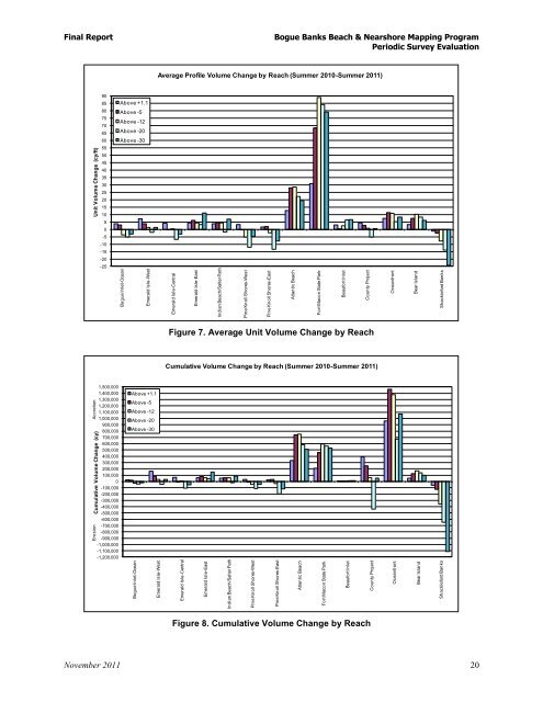
Average Profile Volume Change by Reach (Summer 2010-Summer 2011)<br />
Emerald Isle-Central<br />
Emerald Isle-East<br />
Indian <strong>Beach</strong>/Salter Path<br />
Pine Knoll <strong>Shore</strong>s-West<br />
Pine Knoll <strong>Shore</strong>s-East<br />
Figure 7. Average Unit Volume Change by Reach<br />
Cumulative Volume Change by Reach (Summer 2010-Summer 2011)<br />
Emerald Isle-Central<br />
Emerald Isle-East<br />
Indian <strong>Beach</strong>/Salter Path<br />
Pine Knoll <strong>Shore</strong>s-West<br />
Figure 8. Cumulative Volume Change by Reach<br />
November 2011 20<br />
Pine Knoll <strong>Shore</strong>s-East<br />
Atlantic <strong>Beach</strong><br />
Atlantic <strong>Beach</strong><br />
Fort Macon State Park<br />
Fort Macon State Park<br />
Beaufort Inlet<br />
Beaufort Inlet<br />
<strong>County</strong> Project<br />
<strong>County</strong> Project<br />
Oceanfront<br />
Oceanfront<br />
Bear Island<br />
Bear Island<br />
Shackleford <strong>Banks</strong><br />
Shackleford <strong>Banks</strong>