

Bogue Banks Beach - Carteret County Shore Protection Office
Bogue Banks Beach - Carteret County Shore Protection Office
Bogue Banks Beach - Carteret County Shore Protection Office

Create successful ePaper yourself
Turn your PDF publications into a flip-book with our unique Google optimized e-Paper software.
Final Report <strong>Bogue</strong> <strong>Banks</strong> <strong>Beach</strong> & Nearshore Mapping Program<br />
Periodic Survey Evaluation<br />
Accretion<br />
Erosion<br />
Volume Change (cy/ft)<br />
80<br />
60<br />
40<br />
20<br />
0<br />
-20<br />
-40<br />
-60<br />
-80<br />
-100<br />
-120<br />
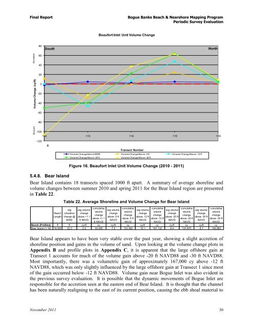
Beaufort Inlet Unit Volume Change<br />
South North<br />
112 113 114 115 116<br />
B<br />
Transect Number<br />
Volume Change Above MHW Volume Change Above -5 ft Volume Change Above -12 ft<br />
Volume Change Above -20 ft Volume Change Above -30 ft<br />
Figure 16. Beaufort Inlet Unit Volume Change (2010 - 2011)<br />
5.4.8. Bear Island<br />
Bear Island contains 18 transects spaced 1000 ft apart. A summary of average shoreline and<br />
volume changes between summer 2010 and spring 2011 for the Bear Island region are presented<br />
in Table 22.<br />
Reach<br />
Length<br />
Table 22. Average <strong>Shore</strong>line and Volume Change for Bear Island<br />
avg<br />
shoreline<br />
change @<br />
MHW<br />
avg volume<br />
change<br />
above +1.1<br />
ft NAVD<br />
cumulative<br />
volume<br />
change<br />
above +1.1<br />
ft NAVD<br />
avg volume<br />
change<br />
above -5 ft<br />
NAVD<br />
cumulative<br />
volume<br />
change<br />
above -5 ft<br />
NAVD<br />
avg volume<br />
change<br />
above -12 ft<br />
NAVD<br />
cumulative<br />
volume<br />
change<br />
above -12 ft<br />
Bear Island appears to have been very stable over the past year, showing a slight accretion of<br />
shoreline position and gains in the volume of sand. Upon looking at the volume change plots in<br />
Appendix B and profile plots in Appendix C, it is apparent that the large offshore gain at<br />
Transect 1 accounts for much of the volume gain above -20 ft NAVD88 and -30 ft NAVD88.<br />
Most importantly, there was a volumetric gain of approximately 167,000 cy above -12 ft<br />
NAVD88, which was only slightly influenced by the large offshore gain at Transect 1 since most<br />
of the gain occurred below -12 ft NAVD88. Volume gain near <strong>Bogue</strong> Inlet was also evident in<br />
the previous survey evaluation. It is possible that the dynamic movements of <strong>Bogue</strong> Inlet are<br />
responsible for the accretion seen at the eastern end of Bear Island. It is thought that the channel<br />
has been naturally realigning to the east of its current position, causing the ebb shoal material to<br />
November 2011 30<br />
NAVD<br />
avg volume<br />
change<br />
above -20 ft<br />
NAVD<br />
cumulative<br />
volume<br />
change<br />
above -20 ft<br />
NAVD<br />
avg volume<br />
change<br />
above -30 ft<br />
NAVD<br />
cumulative<br />
volume<br />
change<br />
above -30 ft<br />
NAVD<br />
Reach (Profiles) ft ft cy/ft cy cy/ft cy cy/ft cy cy/ft cy cy/ft cy<br />
Bear Island (1-18) 16,500 22.3 3.2 53,005 7.5 123,382 10.1 167,132 8.4 137,875 6.1 100,963