colombia - Biblioteca de la Universidad Complutense - Universidad ...
colombia - Biblioteca de la Universidad Complutense - Universidad ...
colombia - Biblioteca de la Universidad Complutense - Universidad ...
You also want an ePaper? Increase the reach of your titles
YUMPU automatically turns print PDFs into web optimized ePapers that Google loves.
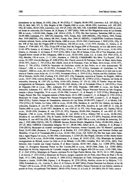
180 José María Cardiel, 1994<br />
alre<strong>de</strong>dores <strong>de</strong> <strong>la</strong>s Minas, 01-1952, DIez, B. 46 (COL); C. Chapón, 06-06-1932, Lawre.nce, A.E. 165 (ff2], O,<br />
OH, E?, MA, MO, NY, 5, US); Región of Mt. Chapón,1000 m s.n.m., 08-06-1932, Lawrence, A.E. 185 (NY,<br />
IJS); El Umbo, 06-03-1933, Lawrence, AB. 654 (E, [2]O, OH, MO, IJS). CALDAS: Be<strong>la</strong>lcazar,1620m s.n.su.,<br />
sin fecha <strong>de</strong> colección, De Fraume, AL & Duque, a 1067 (MA); Valle <strong>de</strong>l Rio Magdalena cerca <strong>de</strong> La Dorada,<br />
200 m s.n.m., 1-20-02-1946, Duque, J.M. 2616-A (COL, F, NY); Rio San Lorenzo, Sa<strong>la</strong>mina,1400 su s.n.m.,<br />
16-09-1883, Lehmann, F.C. 3082 (F); Sa<strong>la</strong>mina, 1943, Tomás, Hiso. 1848 (MEDEL, US); ibí<strong>de</strong>m, 1943, Tomás;<br />
Hno. 1930 (MEDEL, US); ibí<strong>de</strong>m, 08-1943, Tomás, Hizo. 2946 (E, MEDEL). CAQUEré: Cordillera Oriental;<br />
vertiente oriental. Sucre, oril<strong>la</strong>s <strong>de</strong>l Río Hacha, 1000 m s.n.m., 03-04-1940, Cuatrecasas; 1 9038 (COL, US); 10<br />
km. SW of San Jose <strong>de</strong>l Fragua (SW of florencia), 320-340 m s.n.m., 11-01-1974, Davidse, G., Gentry, A. &<br />
L<strong>la</strong>nos, F. 5749 (MO, NY, IJS); 10 km SW of San José <strong>de</strong>l Fragua (SW of Florencia); en low hill aboye river,<br />
11-01-1974, Gentry, A. & L<strong>la</strong>nos, F. 5749 (COL); 10 1cm. 5 of San J 05¿ <strong>de</strong> Fragua, 320 m s.n.m., 11-01-1974,<br />
Genty A., Davidse, G. & L<strong>la</strong>nos, F. 9147 (COL, MO); 5 kni. SE of So<strong>la</strong>no, 81cm. SE of Tres Esquinas, en río<br />
Caquetá below mouth of Río Orteguaza, 2000 m s.n.m., 05.03-1945, Little, EJ. & Little, ItR. 9562 (COl, 5,<br />
US); Morelia, 150 m s.n.m., 11-11-1941, Snei<strong>de</strong>rn, A. 1308 (5). CASANARE: Río Mcta. ‘La Poyata”, 250 su<br />
s.n.m., 01-1937, García-Barriga, H. 5180 (COL); Río Charté, cerca <strong>de</strong> El Palenque, 9 1cm. <strong>de</strong> Mani, tierra firma,<br />
19-02-1971, Sastre, C. 745 (COL); Río Charté, cerca <strong>de</strong> El Palenque, 9 1cm. <strong>de</strong> Maní, tierra ferina, 19-02-1971,<br />
Sastre, C. 744 (COL). CAUCA: Santan<strong>de</strong>r <strong>de</strong> Quilichao; arriba <strong>de</strong> San Pedro, en el sitio <strong>de</strong>nominado “El<br />
Cabuyo”, 1300 su s.n.nt, 05-10-1954, Fernón<strong>de</strong>z-Pére¿ A. 2772 (COL); Santan<strong>de</strong>r <strong>de</strong> Quilicbao; en “Río<br />
Chiquito”, 2000 m s.n.su., 06-10-1954, Fernónda-Pérez, A. 2808 (COL); Ríe Las Piedras en el sitio que <strong>la</strong> carirtera<br />
al Tambo cruza dicho río, 11-11-1955, Fernán<strong>de</strong>z-Pérez,A. 2974 (COL); Piedras and Rio Quilcase 5 km.<br />
NE of Dolores, 26-09-1943, Fosberg, Fi?. 21033 (NY, IJS); Poapayán, carretera al Tambo, río Elegido, 1800 m<br />
s.n.m., 19-07-1948, García-Barriga, H., Hawkes, J.C. & Vil<strong>la</strong>rrea4 M. 12769-A (COL); Popayan, sin fecha <strong>de</strong><br />
colección, Hanweg, M. 1387 (P); La Palía, 19-04-1853, Holton, LF. 254 (G, GE); El Tambo. Hoya <strong>de</strong>l Paría,<br />
corregimiento <strong>de</strong> Mosquera. Aguac<strong>la</strong>ra, 13/19-08-1949, ¡¿¡robo, ¿Al. & Fernán<strong>de</strong>z-Pérez, A. 160 (COL); Cerca<br />
<strong>de</strong> Popayán,1700 su s.n.m., 1881, LeJ,mann, F.C. 844 (US); Popayán, 1400-1800 su s.n.m., sin fecha <strong>de</strong><br />
colección, Lehmann, F.C. 4815 (E, OH, US); Municipio <strong>de</strong> Guapí, Parque Nacional Natural <strong>de</strong> Is<strong>la</strong> Gorgona,<br />
camino a p<strong>la</strong>ya Gorgonil<strong>la</strong>, 70 m s.n.m., 05-06-1986, Lozano-C., O. & Range4 0. 5325 (COL); Municipio <strong>de</strong><br />
Ouapi, Pamue Nal. Nat. Gorgona-camino a Pablo Sexto, 10-11-1987, Lozano-C., G. & Range4 0. 5761 (COL);<br />
Municipio <strong>de</strong> Guapi, Parque Nal. Natural Gorgona-Is<strong>la</strong> Gorgenil<strong>la</strong>, 14-09-1987, Lozano-C, a & Range4 o.<br />
5868 (COL); Tambo, bosque <strong>de</strong> Guasabarita, cabecera río Las Botas, 05-09-1975, López-P., 5. & ¡bobo, J.M.<br />
3754 (COL); El Tambo, La Costa, 1000 su s.n.m., 02-08-1936, Snei<strong>de</strong>rn, K. von 954 (5); ibí<strong>de</strong>m, sin fecha <strong>de</strong><br />
colección, Snei<strong>de</strong>m K. von 955 (5); ibí<strong>de</strong>su,800 m s.n.m., 05-08-1936, Sneklern, K. von 1009 (E, O, IJS); El<br />
Tambe,1800 m s.n.m., 01-05-1937, Sisei<strong>de</strong>r», K. von 1428 (E, O, NY, 115); Prope pagusu, EL Tasube,17(JO su<br />
s.n.m., 20-09-1939, Sizei<strong>de</strong>nn, E?. von 2374 (0, NY); Pepayan, 03-09-1944, Snei<strong>de</strong>rn, K. von 4835 (E, NY);<br />
Popayán, 1700 m s.n.m., 03-09-1944, Sisei<strong>de</strong>riz, E?. von 4835A (COL); ibi<strong>de</strong>m,1700 su s.n.m., 03-09-1944,<br />
Sisei<strong>de</strong>ris, E?. von 4835a (NY, IJS); El Tambo, 20-09-1939, Sneiáern, E?. von A.571 (NY); Popayán, 03-09-1944,<br />
Snei<strong>de</strong>rn, E?. von 4835 bis (OH, 5); Popayan vaheé du Cauca, 1100-1700 su s.n.m., sin fecha <strong>de</strong> colección, Triana,<br />
J. 3585 (BM, [3]COL,OH, P). CESAIL’ Savana, Rincón Hondo, Magdalena Valley, 05-08-1924, Alían, C.<br />
251 (E, MO). CHOCÓ: Comunidad indígena “El 21”, 08-08-1982, Albert <strong>de</strong> E., L., Sánchez; 12 & Bran4 J.<br />
2186 (HIJA); Municipio <strong>de</strong> Acandí: corregimiento San Francisco, vereda Coquital, sitio “El Páramo”, quebrada<br />
Zardí, 22-05-1989, Betancur, 1, Fonnegra, Ji. & Roldón, Fi. 1219 (HIJA); Meng road between Quibdo and<br />
Me<strong>de</strong>llin, 15 km E of Tutunendo,300 su s.n.su., 22.04-1983, Croa4 T.B. 56265 (E); Río San Juan: entre Palestina<br />
y Agua Negra,5 m s.n.m., 01-06-1946, Cuagrecasas, J. 21563 (E); Río Negúa, tributary ofRío Atrato belew<br />
Quibdó, 56-70 m s.n.m., 03-04-1958, Cuatrecasas, J. & L<strong>la</strong>no, Al. 24193 (COL, US); Municipio <strong>de</strong> Quibdó,<br />
corregimiento <strong>de</strong> Bebará, sector La Calle en el río Bebará, 11-02-1985, Córdoba, W.A. 501 (COL, MO); Trail<br />
between Alto Curiche and Casup Curiche, E of Boca Curiche, 20-05-1967, Duke, JA 11298 (NY); Hydro<br />
Camp 15, Eveigreen Seasonal Forest on Rio Curicbe,300 su s.n.m., 08-03-1968, Duke JA 15364 (MO);<br />
Municipio <strong>de</strong> Novita, Inspección <strong>de</strong> Curundó, margen <strong>de</strong>recha río Ingará, 400-550 su s.n.su., 12-01-1983, DIez-<br />
A, £ 3441 (COL); Municipio <strong>de</strong> Pizarro, carretera Pie <strong>de</strong> Pepe-Puerto Meluk, Km. 30-33, 16-11-1985, Espina,<br />
1 & García, F. 1872 (COL); Municipio <strong>de</strong> Pizarro, margen izquierda <strong>de</strong>l río Pepe, entre Boca <strong>de</strong> Pepé y Pie <strong>de</strong><br />
PepÓ, 19-11-1985, Espina, J. & García, F. 2006 (COL); Municipio <strong>de</strong> Tadó, corregimiento <strong>de</strong> Guarato, entie<br />
Guarato y Antón, 10-09-1986, Espina, 1 & Mosquera, Al. 2276 (HIJA); Istsuina, cerros <strong>de</strong> La Mojarra, 7-12-<br />
1990, Fernán<strong>de</strong>z-A., J.L., García, F., Rico, E. & Ve<strong>la</strong>yos, Al. 8607 (MA); Parque Nacional Los Katyos; al sur <strong>de</strong><br />
“Tílupo’t190 su s.n.m., 05-03-1976, Forero, E. & León, H. 98 (MO); Parque Nacional <strong>de</strong> Los ICarios; camino al<br />
puesto <strong>de</strong> Peye, vía quebrada “Del Medio”, 08-03-1976, Forero, E. & León, II. 164 (MO); Río El Valle, cerca a


