colombia - Biblioteca de la Universidad Complutense - Universidad ...
colombia - Biblioteca de la Universidad Complutense - Universidad ...
colombia - Biblioteca de la Universidad Complutense - Universidad ...
You also want an ePaper? Increase the reach of your titles
YUMPU automatically turns print PDFs into web optimized ePapers that Google loves.
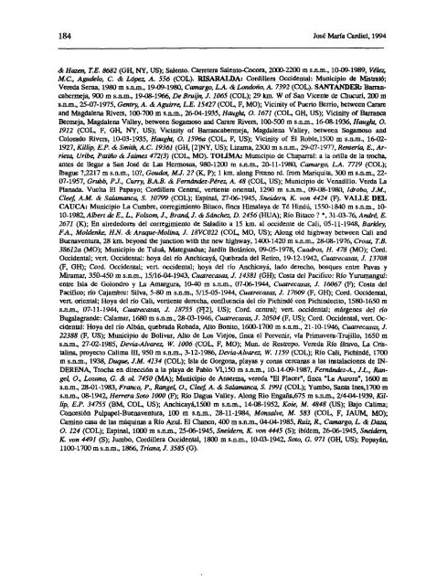
184 José María Cardiel, 1994<br />
& Hazc~ TE. 8682 (OH, NY, LIS); Salento. Carretera Salento-Cocora, 2000-2200 m s.n.m., 10-09-1989, Vélei<br />
Al.C., Agu<strong>de</strong>Za, LX & López A. 556 (COL). RISARALDA: Cordillera Occi<strong>de</strong>ntal: Municipio <strong>de</strong> Mistrató;<br />
Vereda Serna, 1980 m s.n.m., 19-09-1980, Camargo, LA & Londoño, A. 7392 (COL). SANTANDER: Barrancabermeja,<br />
900 m s.nm., 19-08-1966, De Brujfis, £1065 (COL); 29km. W of San Vicente <strong>de</strong> Cbucuri, 200 ni<br />
s.n.m., 25-07-1975, Gentry, A. & Aguirre; L.E. 15427 (COL, F, MO); Vicinity of Puerto Berrio, between Carare<br />
and Magdalena Rivas, 100-700 m s.n.m., 26-04-1935, Haughs, a 1671 (COL, OH, US); Vicinity of Barranca<br />
Bermeja, Magdalena Valley, between Sogamoso and Carate Rivas, 100-500 su s.n.m., 16-08-1936, Uaugh~ a<br />
1912 (COL, E, OH, NY, LIS); Vicinity of Barrancabersueja, Magdalena Valley, between Sogasuoso and<br />
Colorado Rivas, 10-03-1935, Hong/ss, O. 1596a (COL, E, LIS); Vicinity of El Roble,1500 m s.n.su., 16-02-<br />
1927, KilIip, E.?. & Smi4 A.LX 19361 (OH, [2]NY,135); Lizarna, 2300 su s.n.m., 29-07-1977, Jienterfa, E., Arneta,<br />
Uribe, 1’atiño & Jaimes 472(3) (COL, MO). TOLIMA: Municipio <strong>de</strong> Chaparral: a <strong>la</strong> oril<strong>la</strong> <strong>de</strong> <strong>la</strong> trocha,<br />
antes <strong>de</strong> llegar a San José <strong>de</strong> Las Hermosas, 980-1200 m s.n.su., 20-11-1980, Camargo, L.A. 7719 (COL);<br />
lbague ?,2217 su s.n.m., 10?, Goudot, Ah 2? (FC, P); 1 km. along Fresno rd. from Mariquita, 300 m s.n.m., 22-<br />
07-1957, Grubb, Pi, Curr>; B.A.B. & Fernán<strong>de</strong>z-Pérez, A. 48 (COL, LIS); Municipio <strong>de</strong> Venadillo. Verda La<br />
P<strong>la</strong>nada. Vuelta El Papayo; Cordillera Central, vertiente oriental, 1290 su s.n.m., 09-08-1980, Idrobo, J.M.,<br />
Cleef AM. & Sa<strong>la</strong>manca, 5. 10799 (COL); Espinal, 27-06-1945, Snei<strong>de</strong>rn, K. von 4424 (E). VALLE DEL<br />
CAUCA: Municipio La Cumbre, corregimiento HUaco, finca Hima<strong>la</strong>ya <strong>de</strong> Té Hindú, 1550-1840 su s.n.su., 10-<br />
10-1982,Albert <strong>de</strong> E?, L., Folsom, J., Bran4 J. & Sánchez D. 2456 (HIJA); Río Bitaco? t 31-03-76, André, E.<br />
2671 (K); En alre<strong>de</strong>dores <strong>de</strong>l corregimiento <strong>de</strong> Sa<strong>la</strong>dito a 15 1cm. al occi<strong>de</strong>nte <strong>de</strong> Cali, 05-11-1948, Barkley<br />
FA, Mol<strong>de</strong>nke UY. & Araque-Molina, J. 18VC022 (COL, MO, LIS); Along oíd highway between Cali and<br />
Buenaventura, 28 km. beyond dic junction with the new highway, 1400-1420 m s.n.m., 28-08-1976, Croat, T.B.<br />
38612a (MO); Municipio <strong>de</strong> Tuluá, Mateguadua; Jardín Botánico, 09-05-1978, Cuadros, U. 478 (MO); Cord.<br />
Occi<strong>de</strong>ntal; ven. Occi<strong>de</strong>ntal: hoya <strong>de</strong>l río Anchicayá, Quebrada <strong>de</strong>l Retiro, 19-12-1942, Cuarecasas, J. 13708<br />
(E, OH); Cord. Occi<strong>de</strong>ntal; vert. occi<strong>de</strong>ntal; hoya <strong>de</strong>l río Anchicayá, <strong>la</strong>do <strong>de</strong>recho, bosques entre Pavas y<br />
Miraniar, 350-450 su s.n.m., 15/16-04-1943, Cuarecasas, ¿ 14381 (OH); Costa <strong>de</strong>l Pacifico: Río Yurumangul:<br />
entre Is<strong>la</strong> <strong>de</strong> Golondro y La Amargura, 10-40 m s.n.m., 07-06-1944, Cuatrecwas ¿ 16067 (E); Costa <strong>de</strong>l<br />
Pacifico; río Cajambre: Silva, 5-80 su s.n.su., 5/15-05-1944, Cuatrecasas, J. 17609 (E, OH); Cord. Occi<strong>de</strong>ntal,<br />
ven, oriental; Hoya <strong>de</strong>l río Cali, vertiente <strong>de</strong>recha, confluencia <strong>de</strong>l río Pichindé con Pichin<strong>de</strong>cito, 1580-1650 m<br />
s.n.m., 07-11-1944, Cuatrecasas, ¿ 18755 (ff2], LIS); CorO. central; vefl. occi<strong>de</strong>ntal; márgenes <strong>de</strong>l río<br />
Buga<strong>la</strong>gran<strong>de</strong>: Ca<strong>la</strong>mar, 1680 su s.n.su., 28-03-1946, Cuatrecasas, J. 20504 (F, LIS); Cord. Occi<strong>de</strong>ntal, ven. Occi<strong>de</strong>ntal:<br />
Hoya <strong>de</strong>l río Albán, quebrada Robada, Alto Bonito, 1600-1700 su s.n.m., 21-10-1946, Cuatrecasas, ¿<br />
22388 (E, LIS): Municipio <strong>de</strong> Bolívar, Alto <strong>de</strong> Los Viejos, finca el Porvenir, vía Primavera-Trujillo, 1650 m<br />
s.n.su., 27-02-1985, Devia-Alvarez, lE 1006 (COL, F, MO); Mun. <strong>de</strong> Restrepo. Vereda Río Bravo, La Cristalina,<br />
proyecto Calima m, 950 m s.n.m., 3-12-1986, Devia-Alvarez, lE 1159 (COL); Río Cali, Pichindó, 1700<br />
m s.n.m., 1938, Duque; J.M. 4134 (COL); Is<strong>la</strong> <strong>de</strong> Gorgona, p<strong>la</strong>yas y conas cercanas a <strong>la</strong>s insta<strong>la</strong>ciones <strong>de</strong> IN-<br />
DERENA, Trocha en dirección a <strong>la</strong> p<strong>la</strong>ya <strong>de</strong> Pablo VI,150 su s.n.m., 10-14-09-1987, Fernán<strong>de</strong>z-A., J.L., Jiangel,<br />
O., Lozano, G. & aL 7450 (MA); Municipio <strong>de</strong> Anserma, vereda “El P<strong>la</strong>cer”, finca “La Aurora”, 1600 m<br />
s.n.m., 28-01-1983, Franco, P., Rangel, a, Cle4 A. & Sa<strong>la</strong>manca, £ 1991 (COL); Yumbo, Santa Ines,1700 m<br />
s.n.m., 08-1942, Uerrera Soto 1000 (F); Río Dagua Valley. Along Rio Enga~a,675 su s.n.m., 2/4-04-1939, Killip<br />
ES’. 34755 (BM, COL, LIS); Anchicayá,1500 m s.n.m., 14-08-1952, Koie; Al. 4848 (LIS); Bajo Calima;<br />
Concesión Pulpapel-Buenaventura, 100 m s.n.m., 28-11-1984, Alonsalve; Al. 583 (COL, E, JAUM, MO);<br />
Camino casa <strong>de</strong> <strong>la</strong>s máquinas a Río Azul. El Chanco, 400 su s.n.m., 04-04-1985, Ruiz; R., Camargo, L. & Daza,<br />
0. 124 (COL); Espinal, 1000 m s.n.m., 25-06-1945, Snei<strong>de</strong>rn, K. von 4445 (5); ibí<strong>de</strong>m, 26-06-1945, Snei<strong>de</strong>rn,<br />
IC von 4491 (5); Junto, Cordillera Occi<strong>de</strong>ntal, 1800 su s.n.m, 10-03-1942, Soto, 0. 971 (OH, LIS); Popayán,<br />
1100-1700 su s.n.m., 1866, Triana, J. 3585(0).


