Descargue esta publicació en formato pdf haciendo ... - INSUGEO
Descargue esta publicació en formato pdf haciendo ... - INSUGEO
Descargue esta publicació en formato pdf haciendo ... - INSUGEO

Create successful ePaper yourself
Turn your PDF publications into a flip-book with our unique Google optimized e-Paper software.
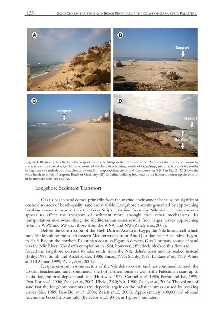
133SAND CHARACTERISTICS AND BEACH PROFILES OF THE COAST OF GAZA STRIP, PALESTINEFigure 4. Illustrates the effects of the seaport and the buildings in the foreshore zone. (A) Shows the results of erosion bythe waves in the coastal ridge. Direct to north of the Es-Safina building, north of Gaza Strip, site 3. (B) Shows the resultsof high rate of sands deposition, directly to south of seaport, Gaza city, site 4. Compare sites 3 & 4 in Fig. 2. (C) Shows thewide beach to north of seaport. Beach of Gaza city. (D) Es-Safina building bounded by the barriers, increasing the erosionin its northern side (see also A).Longshore Sedim<strong>en</strong>t TransportGaza’s beach sand comes primarily from the marine <strong>en</strong>vironm<strong>en</strong>t because no significantonshore sources of beach-quality sand are available. Longshore curr<strong>en</strong>ts g<strong>en</strong>erated by approachingbreaking waves transport it to the Gaza Strip’s coastline from the Nile delta. These curr<strong>en</strong>tsappear to affect the transport of sedim<strong>en</strong>t more strongly than other mechanisms. Itstransportation northward along the Mediterranean coast results from larger waves approachingfrom the WSW and SW than those from the WNW and NW (Zviely et al., 2007).Before the construction of the High Dam at Aswan in Egypt, the Nile littoral cell, whichruns 650 km along the south-eastern Mediterranean from Abu Quir Bay near Alexandria, Egypt,to Haifa Bay on the northern Palestinian coast, as Figure 6 depicts, Gaza’s primary source of sandwas the Nile River. The dam’s completion in 1964, however, effectively blocked this flow andforced the longshore curr<strong>en</strong>ts to take sands from the Nile delta’s coast and its seabed instead(Frihy, 1988; Smith and Abdel Kader, 1988; Fanos, 1995; Stanly, 1998; El-Raey et al., 1999; Whiteand El Asmar, 1999; Zviely et al., 2007).Despite erosion in some sectors of the Nile delta’s coast, sand has continued to reach theup-drift beaches and inner contin<strong>en</strong>tal shelf of northern Sinai as well as the Palestinian coast up toHaifa Bay, the final depositional sink (Horowitz, 1979; Carmel et al., 1985; Perlin and Kit, 1999;D<strong>en</strong>-Dor et al., 2006; Zviely et al., 2007; Ubeid, 2010; Nir, 1980; Zviely et al., 2006). The volume ofsand that the longshore curr<strong>en</strong>ts carry dep<strong>en</strong>ds largely on the radiation stress caused by breakingwaves (Nir, 1989; B<strong>en</strong>-Dor et al., 2006; Zviely et al., 2007). Approximately 400,000 m 3 of sandreaches the Gaza Strip annually (B<strong>en</strong>-Dor et al., 2006), as Figure 6 indicates.
![Descargar El Libro Completo [5.631 Kb] - INSUGEO](https://img.yumpu.com/40710231/1/177x260/descargar-el-libro-completo-5631-kb-insugeo.jpg?quality=85)