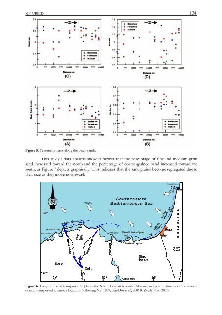
K.F. UBEID 134Figure 5. Textural patterns along the beach sands.This study’s data analysis showed further that the perc<strong>en</strong>tage of fine and medium-grainsand increased toward the north and the perc<strong>en</strong>tage of coarse-grained sand increased toward thesouth, as Figure 7 depicts graphically. This indicates that the sand grains become segregated due totheir size as they move northward.Figure 6. Longshore sand transport (LST) from the Nile delta coast towards Palestine; and yearly estimates of the amountof sand transported at various locations (following Nir, 1989; B<strong>en</strong>-Dor et al., 2006 & Zveily et al., 2007).
135SAND CHARACTERISTICS AND BEACH PROFILES OF THE COAST OF GAZA STRIP, PALESTINEFigure 7. Significant correlations of grain size distributions along the beach sands.ConclusionsThis study’s survey of the Gaza Strip’s coastal zone found that its beaches t<strong>en</strong>d to b<strong>en</strong>arrower in its middle and north than in its south and its northernmost stretch. An exception isthat the beach t<strong>en</strong>ds to be wide south of Gaza seaport in its middle stretch due an increase in thedepositional rate and in the rate of erosion north of it.The slope of the beach profile along the coastline varies from a few degrees to 90 degrees.The height of the sea cliffs of the coastal ridge is higher in its middle and northern stretches thanin the south, where it dies out into sand dunes.All of the Gaza Strip’s beaches are sandy. Longshore curr<strong>en</strong>ts transport these sands alongthe eastern shore of the Mediterranean Sea from the Nile delta. This study’s analysis of 36 samplesfrom 12 locations along these beaches found that the sand grains become segregated as they movefrom south to north, becoming increasingly fine as they go. They are in g<strong>en</strong>eral predominantlymedium grained. On most of the beaches they are moderately well sorted, due mainly to theactions of marine curr<strong>en</strong>ts, waves, and tides.Refer<strong>en</strong>cesBartov, Y., Arkin, Y., Lewy, Z., and Mimran, Y. 1981. Regional stratigraphy of Israel: A guide to geological mapping.Geological Survey of Israel, Stratigraphic Chart.B<strong>en</strong>-Dor, E., Levin, N., Singer, A., Karnieli, A., Braun, O., and Kidron, G.J. 2006. Quantitative mapping of the soilrubification process on sand dunes using an airborne hyperspectral s<strong>en</strong>sor. Geoderma, 131: 1-21.Bird, E. 2000. Coastal Geomorphology: An Introduction. Chichester, England, John Wiley & Sons, Ltd., 322 p.Blott, S.J., and Pye, K. 2001. Gradistat : a grain size distribution and statistics package for analysis of unconsolidatedsedim<strong>en</strong>ts. Earth Surface Processes and Landforms, 26: 1237–1248.Carranza-Edwards, A. 2001. Grain size and sorting in modern beach sands. Journal of Coastal Research, 17: 38-52.


![Descargar El Libro Completo [5.631 Kb] - INSUGEO](https://img.yumpu.com/40710231/1/177x260/descargar-el-libro-completo-5631-kb-insugeo.jpg?quality=85)