Magnetotelúrico e Eletromagnético Transiente - CPRM
Magnetotelúrico e Eletromagnético Transiente - CPRM
Magnetotelúrico e Eletromagnético Transiente - CPRM

You also want an ePaper? Increase the reach of your titles
YUMPU automatically turns print PDFs into web optimized ePapers that Google loves.
Abstract<br />
This research work aims to contribute to the hydrogeologic knowledge of the eastern<br />
margin of the Parnaíba basin through a geophysical investigation by using magnetotelluric (MT)<br />
and transient electromagnetic (TEM) methods. Both methods give estimates of subsurface<br />
electric resistivities. From the resistivity mapping of the subsurface it is possible to differentiate<br />
sandstone layers (moderately resistive) from shale layers (more conductive relative to the first<br />
ones) and the crystalline basement (more resistive), making possible a visualization of the basin's<br />
structure.<br />
The Parnaíba basin is located to the west side of the northeastern region of Brazil. It<br />
occupies an area of about 600000 km 2 with an approximate 3400 m maximum sedimentary<br />
thickness near its central position. It is an intracratonic basin where one finds Ordovician to<br />
Tertiary sedimentary deposits and intrusive and extrusive rocks associated to magmatic events<br />
from Jurassic to eo-cretaceous ages. On a hydrogeologic context, the Cabeças geologic<br />
formation and the Serra Grande group (both predominantly sandstones) contain the most<br />
important aquifers in the region.<br />
The Serra Grande group and the Pimenteiras formation predominate in the study area.<br />
They stand over a semi-arid region, particular to most of northeastern Brazil countryside where<br />
water shortage is a long and well-known problem to the region. This fact also calls for the<br />
importance towards a better understanding of the region's hydrogeology. Geophysical studies<br />
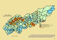
presented in this dissertation are based on 28 MT and TEM stations sited upon three cross-section<br />
profiles relative to the area's main structures. These three profiles are (see fig. 2.3):<br />
· (1) the Monsenhor Hipólito profile, 58 km long with 9 MT/TEM stations, 4 to 12 km away one<br />
from the other.<br />
· (2) the Jaicós profile, 22 km long with 9 MT/TEM stations, each 4 to 6 km away from the other.<br />
· (3) the Itainópolis profile, 41 km long with 10 MT/TEM stations, 4 to 6 km away one from the<br />
other.<br />
In all three profiles the MT frequency was sampled between 0.07-0.008 Hz and 334 Hz<br />
whereas TEM measurements were taken between 33 Hz and 100000 Hz. In order to estimate the<br />
impedance tensor and its related apparent resistivities and phases, a robust computer processing<br />
technique given by Egbert & Eisel (2000) was used. To determine the geoelectric strike, Groom<br />
and Bailey's (1989) technique was used. For static shift correction of MT data, we used the<br />
TEM-method's apparent resistivity curves based on Sternberg's (1988) proposal. MT data<br />
v