Archivserver der Deutschen Nationalbibliothek
Archivserver der Deutschen Nationalbibliothek
Archivserver der Deutschen Nationalbibliothek

Erfolgreiche ePaper selbst erstellen
Machen Sie aus Ihren PDF Publikationen ein blätterbares Flipbook mit unserer einzigartigen Google optimierten e-Paper Software.
46 Wirkung von Habitatsstrukturen auf die Benthoszönose<br />
1998, Tittizer et al. 2000). To enable a further recovery of the aquatic fauna, besides<br />
chemical also the physical improvement of habitat quality becomes increasingly important.<br />
Main attention of this study was to assess the environmental changes within groyne<br />
fields induced by two new groyne forms. Carabid beetles and macrozoobenthos taxa were<br />
monitored prior to and after groyne modification to evaluate effects of different flow<br />
velocities and resulting sedimentary deposition on the distribution patterns of the species<br />
assemblages and the stenotopic species Bembidion velox and Gomphus flavipes.<br />
Design and function of modified groynes<br />
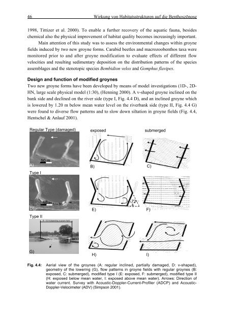
Two new groyne forms have been developed by means of model investigations (1D-, 2D-<br />
HN, large scale physical model (1:30), (Henning 2000). A v-shaped groyne inclined on the<br />
bank side and declined on the river side (type I, Fig. 4.4 D), and an inclined groyne which<br />
is lowered by 1.20 m below mean water level on the riverbank side (type II, Fig. 4.4 G)<br />
were found to diverse flow patterns and to slow down siltation in groyne fields (Fig. 4.4,<br />
Hentschel & Anlauf 2001).<br />
Regular Type (damaged)<br />
exposed<br />
submerged<br />
A)<br />
Type I<br />
50 m<br />
B) C)<br />
D)<br />
50 m<br />
E)<br />
72<br />
°<br />
F)<br />
Type II<br />
8 - 12 m (depending on groyne hight)<br />
mean water level<br />
1:3<br />
1:3<br />
mw - 1.2 m<br />
G)<br />
Fig. 4.4:<br />
H) I)<br />
Aerial view of the groynes (A: regular inclined, partially damaged, D: v-shaped),<br />
geometry of the lowering (G), flow patterns in groyne fields with regular groynes (B:<br />
exposed, C: submerged), modified type I (E: exposed, F: submerged), modified type II<br />
(H: exposed below mean water, I: exposed above mean water). Arrows: Direction of<br />
water current. Survey with Acoustic-Doppler-Current-Profiler (ADCP) and Acoustic-<br />
Doppler-Velocimeter (ADV) (Simpson 2001).