Geographica Augustana - Institut für Geographie und ...
Geographica Augustana - Institut für Geographie und ...
Geographica Augustana - Institut für Geographie und ...

Erfolgreiche ePaper selbst erstellen
Machen Sie aus Ihren PDF Publikationen ein blätterbares Flipbook mit unserer einzigartigen Google optimierten e-Paper Software.
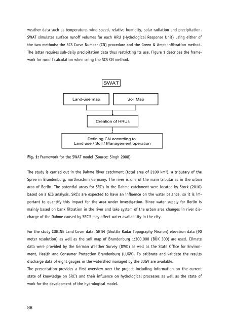
weather data such as temperature, wind speed, relative humidity, solar radiation and precipitation.SWAT simulates surface runoff volumes for each HRU (Hydrological Response Unit) using either ofthe two methods: the SCS Curve Number (CN) procedure and the Green & Ampt infiltration method.The latter requires sub-daily precipitation data thus restricting its use. Figure 1 describes the frameworkfor runoff calculation when using the SCS-CN method.SWATLand-use mapSoil Wetness Soil MapIndexCreation of HRUsDefining CN according toLand use / Soil / Management operationFig. 1: Framework for the SWAT model (Source: Singh 2008)The study is carried out in the Dahme River catchment (total area of 2100 km²), a tributary of theSpree in Brandenburg, northeastern Germany. The river is one of the main tributaries in the urbanarea of Berlin. The potential areas for SRC's in the Dahme catchment were located by Stork (2010)based on a GIS analysis. SRC's are expected to have an influence on the water balance, so it is importantto quantify this impact for the area <strong>und</strong>er investigation. Since water supply for Berlin ismainly based on bank filtration in the river and lake system of the urban area changes in river dischargeof the Dahme caused by SRC'S may affect water availability in the city.For the study CORINE Land Cover data, SRTM (Shuttle Radar Topography Mission) elevation data (90meter resolution) as well as the soil map of Brandenburg 1:300.000 (BÜK 300) are used. Climatedata were provided by the German Weather Survey (DWD) as well as the State Office for Environment,Health and Consumer Protection Brandenburg (LUGV). To calibrate and validate the resultsdischarge data of eight gauges in the watershed managed by the LUGV are available.The presentation provides a first overview over the project including information on the currentstate of knowledge on SRC’s and their influence on hydrological processes as well as the state ofwork for the development of the hydrological model.88