

MapInfo Professional 11.5 Install Guide - Product Documentation ...
MapInfo Professional 11.5 Install Guide - Product Documentation ...
MapInfo Professional 11.5 Install Guide - Product Documentation ...

Create successful ePaper yourself
Turn your PDF publications into a flip-book with our unique Google optimized e-Paper software.
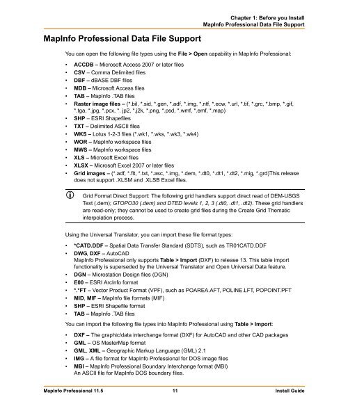
<strong>MapInfo</strong> <strong>Professional</strong> Data File Support<br />
Chapter 1: Before you <strong>Install</strong><br />
<strong>MapInfo</strong> <strong>Professional</strong> Data File Support<br />
You can open the following file types using the File > Open capability in <strong>MapInfo</strong> <strong>Professional</strong>:<br />
• ACCDB – Microsoft Access 2007 or later files<br />
• CSV – Comma Delimited files<br />
• DBF – dBASE DBF files<br />
• MDB – Microsoft Access files<br />
• TAB – <strong>MapInfo</strong> .TAB files<br />
• Raster image files – (*.bil, *.sid, *.gen, *.adf, *.img, *.ntf, *.ecw, *.url, *.tif, *.grc, *.bmp, *.gif,<br />
*.tga, *.jpg, *.pcx, *. jp2, *.j2k, *.png, *.psd, *.wmf, *.emf, *.map)<br />
• SHP – ESRI Shapefiles<br />
• TXT – Delimited ASCII files<br />
• WKS – Lotus 1-2-3 files (*.wk1, *.wks, *.wk3, *.wk4)<br />
• WOR – <strong>MapInfo</strong> workspace files<br />
• MWS – <strong>MapInfo</strong> workspace files<br />
• XLS – Microsoft Excel files<br />
• XLSX – Microsoft Excel 2007 or later files<br />
• Grid images – (*.adf, *.flt, *.txt, *.asc, *.img, *.dem, *.dt0, *.dt1, *.dt2, *.mig, *.grd)This release<br />
does not support .XLSM and .XLSB Excel files.<br />
Grid Format Direct Support: The following grid handlers support direct read of DEM-USGS<br />
Text (.dem); GTOPO30 (.dem) and DTED levels 1, 2, 3 (.dt0, .dt1, .dt2). These grid handlers<br />
are read-only; they cannot be used to create grid files during the Create Grid Thematic<br />
interpolation process.<br />
Using the Universal Translator, you can import these file format types:<br />
• *CATD.DDF – Spatial Data Transfer Standard (SDTS), such as TR01CATD.DDF<br />
• DWG, DXF – AutoCAD<br />
<strong>MapInfo</strong> <strong>Professional</strong> only supports Table > Import (DXF) to release 13. This table import<br />
functionality is superseded by the Universal Translator and Open Universal Data feature.<br />
• DGN – Microstation Design files (DGN)<br />
• E00 – ESRI ArcInfo format<br />
• *.*FT – Vector <strong>Product</strong> Format (VPF), such as POAREA.AFT, POLINE.LFT, POPOINT.PFT<br />
• MID, MIF – <strong>MapInfo</strong> file formats (MIF)<br />
• SHP – ESRI Shapefile format<br />
• TAB – <strong>MapInfo</strong> .TAB files<br />
You can import the following file types into <strong>MapInfo</strong> <strong>Professional</strong> using Table > Import:<br />
• DXF – The graphic/data interchange format (DXF) for AutoCAD and other CAD packages<br />
• GML – OS MasterMap format<br />
• GML, XML – Geographic Markup Language (GML) 2.1<br />
• IMG – A file format for <strong>MapInfo</strong> <strong>Professional</strong> for DOS image files<br />
• MBI – <strong>MapInfo</strong> <strong>Professional</strong> Boundary Interchange format (MBI)<br />
An ASCII file for <strong>MapInfo</strong> DOS boundary files.<br />
<strong>MapInfo</strong> <strong>Professional</strong> <strong>11.5</strong> 11 <strong>Install</strong> <strong>Guide</strong>


