MARICO Marine NZ Limited WELLINGTON HARBOUR PORT AND ...
MARICO Marine NZ Limited WELLINGTON HARBOUR PORT AND ...
MARICO Marine NZ Limited WELLINGTON HARBOUR PORT AND ...
You also want an ePaper? Increase the reach of your titles
YUMPU automatically turns print PDFs into web optimized ePapers that Google loves.
Report No: 05<strong>NZ</strong>104 <strong>WELLINGTON</strong> <strong>HARBOUR</strong><br />
Issue: 1.1 Operational Risk Assessment<br />
_____________________________________________________________________________________________<br />
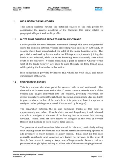
1 <strong>WELLINGTON</strong>’S PINCHPOINTS<br />
This annex explores further the potential causes of the risk profile by<br />
considering the generic problems of the Harbour; this being related to<br />
geographical layout and traffic profile.<br />
1.1 OUTER PILOT BOARDING AREAS TO <strong>HARBOUR</strong> ENTRANCE<br />
Ferries provide the most frequent movement through this area and potential<br />
exists for collision between vessels proceeding with pilot in or outbound, or<br />
vessels which have disembarked the pilot at the inner boarding area. The<br />
potential is reduced by ferries and other Pilotage exempt vessels joining the<br />
leads at two miles off, while the Outer Boarding Areas are nearly three miles<br />
south of the entrance. Vessels embarking a pilot at position ‘Charlie’ to the<br />
west of the leads however, are likely to pass through the ferry transit area<br />
while gaining the leads after embarkation.<br />
Risk mitigation is provided by Beacon Hill, which has both visual and radar<br />
surveillance of the area.<br />
1.2 STEEPLE ROCK BEACON<br />
This is a course alteration point for vessels both in and outbound. The<br />
channel is at its narrowest and at the 10 metre contour extends south of the<br />
beacon and bulges somewhat into the channel, providing restriction for<br />
deeper draught vessels (although those operating at minimum UKC are likely<br />
to proceed down the line of the leads from this point and have the option to<br />
navigate under privilege as a vessel ‘Constrained by Draught’).<br />
The separation between the in and outbound tracks at this point is<br />
approximately one cable. Vessels which are not deep draught and inbound<br />
are able to navigate to the east of the leading line to increase this passing<br />
distance. Small craft are also known to navigate to the west of Steeple<br />
Beacon and in doing so keep clear of large vessels.<br />
The presence of small vessels or leisure craft in this area, particularly sailing<br />
craft tacking across the channel, can further restrict manoeuvring options or<br />
add pressure to watch keepers of larger vessels. Small craft (in this case<br />
generally runabouts and launches) are known to navigate to the west of<br />
Steeple Beacon and in doing so keep clear of large vessels. Leisure craft are<br />
permitted through Bylaw to keep to either side of the main shipping channel.<br />
Greater Wellington Regional Council /<br />
CentrePort Ltd Page D1 of D5


