MARICO Marine NZ Limited WELLINGTON HARBOUR PORT AND ...
MARICO Marine NZ Limited WELLINGTON HARBOUR PORT AND ...
MARICO Marine NZ Limited WELLINGTON HARBOUR PORT AND ...

You also want an ePaper? Increase the reach of your titles
YUMPU automatically turns print PDFs into web optimized ePapers that Google loves.
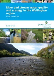
Report No: 05<strong>NZ</strong>104 <strong>WELLINGTON</strong> <strong>HARBOUR</strong><br />
Issue: Issue 1.1 Operational Risk Assessment<br />
The area is subject to heavy gusts off high land and funnelling down gorges<br />
(Ngauranga and Kaiwharawhara) which affect small craft, particularly those<br />
under sail, and also larger vessels manoeuvring in strong winds8. 5.4.3 Area C - Tidal Regime<br />
No significant streams occur in the harbour, the exception being flow from<br />
the Hutt River, particularly during floods. This is reported to cause short<br />
steep waves locally in conjunction with gale events.<br />
5.4.4 Area C - Navigational Use<br />
The area is not under radar monitoring or visual surveillance from Beacon<br />
Hill. Large vessels transit Area C whilst in or outbound and the area also<br />
includes the Rail Ferry Terminal, Thorndon Container Terminal, Aotea Quay<br />
and Seaview Oil Terminal; all major wharf and berth facilities. Seaview has<br />
a lack of reference points in the approach, making berthing recommended by<br />
pilots with significant experience only. Seaview is also affected in a<br />
southerly gale and the short seas which form can affect tug ability to push<br />
on. As the Seaview jetty is not aligned with the wind direction in a<br />
southerly, misjudgement on an approach has the potential to result in a<br />
serious incident.<br />
The harbour ferry regularly transits across Area C, operating a service from<br />
Lambton Harbour to Days Bay wharf and also to Matiu/Somes island<br />
several times a day. Thorndon Container Terminal is interesting in that its<br />
geographical layout places the berth face approximately parallel with winds<br />
from the south or north (the predominant patterns). Large vessels alongside<br />
are thus mostly head or stern to wind and pilots are adept at using wind<br />
loading on the hull plane for berthing or departing.<br />
Large vessels transiting the harbour are generally following the<br />
Recommended Tracks (see Figure B1, Annex B and section 11.2.2). These<br />
tracks occupy the south western part of Area C. However tankers and tugs<br />
routinely transit across the area to and from Seaview oil terminal, and<br />
occasionally passenger vessels will transit the harbour outbound along the<br />
Hutt Motorway and to the north of Matiu/Somes Island.<br />
Leisure craft of all types may be encountered in Area C, including keeler<br />
yacht races throughout the area, fishing craft and kayaks along the<br />
shorelines and around the islands and all types of leisure craft transiting<br />
8 Large Vessels may need a speed of 8 knots to be responsive to the rudder in these conditions.<br />
Greater Wellington Regional Council /<br />
CentrePort Ltd Page 37 of 102