MARICO Marine NZ Limited WELLINGTON HARBOUR PORT AND ...
MARICO Marine NZ Limited WELLINGTON HARBOUR PORT AND ...
MARICO Marine NZ Limited WELLINGTON HARBOUR PORT AND ...

Create successful ePaper yourself
Turn your PDF publications into a flip-book with our unique Google optimized e-Paper software.
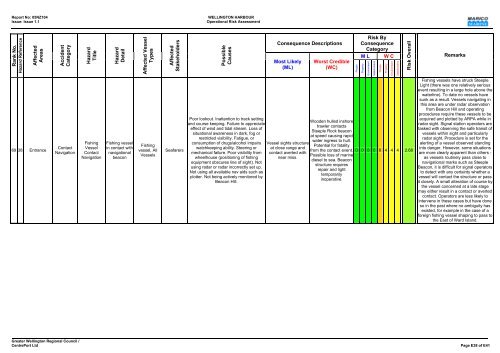
Report No: 05<strong>NZ</strong>104 <strong>WELLINGTON</strong> <strong>HARBOUR</strong><br />
Issue: Issue 1.1 Operational Risk Assessment<br />
Rank No.<br />
Hazard Reference<br />
Affected<br />
Areas<br />
69 38 Entrance<br />
Accident<br />
Category<br />
Contact<br />
Navigation<br />
Hazard<br />
Title<br />
Fishing<br />
Vessel<br />
Contact<br />
Navigation<br />
Hazard<br />
Detail<br />
Fishing vessel<br />
in contact with<br />
navigational<br />
beacon<br />
Affected Vessel<br />
Types<br />
Fishing<br />
vessel, All<br />
Vessels<br />
Affected<br />
Stakeholders<br />
Seafarers<br />
Possible<br />
Causes<br />
Poor lookout. Inattention to track setting<br />
and course keeping. Failure to appreciate<br />
effect of wind and tidal stream. Loss of<br />
situational awareness in dark, fog or<br />
restricted visibility. Fatigue, or<br />
consumption of drugs/alcohol impairs<br />
watchkeeping ability. Steering or<br />
mechanical failure. Poor visibility from<br />
wheelhouse (positioning of fishing<br />
equipment obscures line of sight). Not<br />
using radar or radar incorrectly set up.<br />
Not using all available nav aids such as<br />
plotter. Not being actively monitored by<br />
Beacon Hill.<br />
Consequence Descriptions<br />
Most Likely<br />
(ML)<br />
Vessel sights structure<br />
at close range and<br />
contact averted with<br />
near miss.<br />
Worst Credible<br />
(WC)<br />
Risk By<br />
Consequence<br />
Category<br />
M L W C<br />
Greater Wellington Regional Council /<br />
CentrePort Ltd Page E38 of E41<br />
People<br />
Property<br />
Environment<br />
Stakeholders<br />
People<br />
Property<br />
Environment<br />
Stakeholders<br />
Risk Overall<br />
Wooden hulled inshore<br />
trawler contacts<br />
Steeple Rock beacon<br />
at speed causing rapid<br />
water ingress to hull.<br />
Potential for fatality<br />
from the contact event. 0 0 0 0 6 4 4 4 2.68<br />
Possible loss of marine<br />
diesel to sea. Beacon<br />
structure requires<br />
repair and light<br />
temporarily<br />
inoperative.<br />
Remarks<br />
Fishing vessels have struck Steeple<br />
Light (there was one relatively serious<br />
event resulting in a large hole above the<br />
waterline). To date no vessels have<br />
sunk as a result. Vessels navigating in<br />
this area are under radar observation<br />
from Beacon Hill and operating<br />
procedures require these vessels to be<br />
acquired and plotted by ARPA while in<br />
radar sight. Signal station operators are<br />
tasked with observing the safe transit of<br />
vessels within sight and particularly<br />
radar sight. Procedure is set for the<br />
alerting of a vessel observed standing<br />
into danger. However, some situations<br />
are more clearly apparent than others -<br />
as vessels routinely pass close to<br />
navigational marks such as Steeple<br />
Beacon, it is difficult for signal operators<br />
to detect with any certainty whether a<br />
vessel will contact the structure or pass<br />
it closely. A small alteration of course by<br />
the vessel concerned at a late stage<br />
may either result in a contact or averted<br />
contact. Operators are less likely to<br />
intervene in these cases but have done<br />
so in the past where no ambiguity has<br />
existed, for example in the case of a<br />
foreign fishing vessel shaping to pass to<br />
the East of Ward Island.