2013 VACATION PLANNER - Travel Yukon
2013 VACATION PLANNER - Travel Yukon
2013 VACATION PLANNER - Travel Yukon

You also want an ePaper? Increase the reach of your titles
YUMPU automatically turns print PDFs into web optimized ePapers that Google loves.
Campbell /<br />
Canol Route<br />
Regions on this Route<br />
Watson Lake, p.30<br />
Southern Lakes, p.36<br />
Whitehorse, p.44<br />
Campbell, p.70<br />
Klondike, p.82<br />
Route<br />
The Robert Campbell Highway and Canol<br />
Road criss-cross pristine <strong>Yukon</strong> wilderness<br />
northeast of Whitehorse.<br />
Distance: 500 to 1,000 km<br />
Time recommended: Minimum 2 nights<br />
Features: Quiet, Little Salmon and Frances<br />
lakes, Pelly River, Fannin sheep, Canol Road<br />
Activities: Fishing and boating in roadside<br />
lakes, golfing and hiking around Faro,<br />
interpretive tours, camping, wildlife<br />
viewing, canoeing the Big Salmon River<br />
(Gyò Cho Chú)<br />
Trip Planning<br />
Places to visit: Carmacks, Faro, Ross River,<br />
Watson Lake, Teslin, Johnsons Crossing,<br />
Marsh Lake, Whitehorse<br />
Distances and approximate driving times:<br />
• Watson Lake to Carmacks via Ross River:<br />
583 km (12 hrs)<br />
• Johnsons Crossing to Ross River:<br />
225 km (5 hrs)<br />
Highways travelled:<br />
Robert Campbell Highway #4,<br />
South Canol Road #6, Alaska Highway #1,<br />
and North Klondike Highway #2<br />
Local Attractions<br />
• Campbell Region Interpretive Centre<br />
• Mount Mye Sheep Centre<br />
• Fisheye Lake<br />
• Quiet Lake<br />
• Canol Footbridge<br />
• Dena Cho Trail<br />
• Lapie Canyon<br />
• Rose Lake (L’ex Hîni Shâk Âyi)<br />
Marsh Lake<br />
<strong>Yukon</strong><br />
Carmacks<br />
Faro<br />
Ross River<br />
WHITEHORSE<br />
Johnsons Crossing<br />
Teslin<br />
Watson<br />
Lake<br />
Road Less <strong>Travel</strong>led<br />
Traversing one of the <strong>Yukon</strong>’s leastpopulated<br />
regions, the Campbell/Canol<br />
wilderness route offers a quiet, more<br />
remote experience with rewarding<br />
fishing and wildlife viewing.<br />
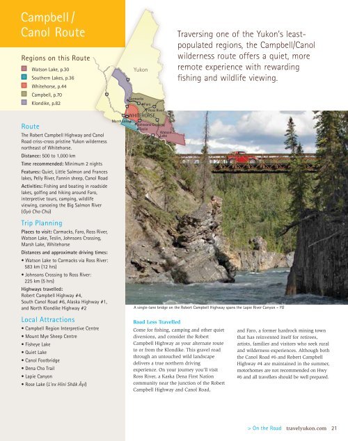
A single-lane bridge on the Robert Campbell Highway spans the Lapie River Canyon – YG<br />
Come for fishing, camping and other quiet<br />
diversions, and consider the Robert<br />
Campbell Highway as your alternate route<br />
to or from the Klondike. This gravel road<br />
through an untouched wild landscape<br />
delivers a true northern driving<br />
experience. On your journey you’ll visit<br />
Ross River, a Kaska Dena First Nation<br />
community near the junction of the Robert<br />
Campbell Highway and Canol Road,<br />
and Faro, a former hardrock mining town<br />
that has reinvented itself for retirees,<br />
artists, families and visitors who seek rural<br />
and wilderness experiences. Although both<br />
the Canol Road #6 and Robert Campbell<br />
Highway #4 are maintained in the summer,<br />
motorhomes are not recommended on Hwy<br />
#6 and all travellers should be well prepared.<br />
> On the Road travelyukon.com 21