2013 VACATION PLANNER - Travel Yukon
2013 VACATION PLANNER - Travel Yukon
2013 VACATION PLANNER - Travel Yukon

Create successful ePaper yourself
Turn your PDF publications into a flip-book with our unique Google optimized e-Paper software.
Dempster<br />
Highway Dempster Highway Route<br />
<strong>Travel</strong> from Dawson City to Canada’s<br />
Arctic across breathtaking mountain<br />
Regions on this Route<br />
North <strong>Yukon</strong>, p.92<br />
Crossing the Arctic Circle<br />
The Dempster Highway #5 is Canada’s<br />
only all-season public road to cross the<br />
Arctic Circle and is among the world’s<br />
most unique driving routes. A drive up<br />
this unpaved, two-lane highway begins<br />
with a visit to Tombstone Territorial Park,<br />
a haunting landscape memorable for its<br />
jagged peaks and colour-stained hills.<br />
You’ll find plenty of pullouts, day hikes<br />
and natural diversions along the Dempster<br />
including abundant wildlife. You’ll cross<br />
the Arctic Circle, where the sun doesn’t<br />
set on summer solstice. With limited<br />
services, two river crossings by ferry, and<br />
long stretches across open tundra,<br />
travellers are urged to be prepared.<br />
Silver Trail<br />
Regions on this Route<br />
Silver Trail, p.76<br />
Silver and the Stewart<br />
Highway #11, the winding Silver Trail,<br />
passes through moose habitat and offers<br />
scenic views of the Stewart River. A<br />
major tributary of the <strong>Yukon</strong> River, the<br />
Stewart lured prospectors to the area in<br />
the 1880s, which led to major mineral<br />
discoveries. Today, Mayo is a thriving<br />
regional centre that serves tourism,<br />
outfitting and mining. Hiking and biking<br />
trails abound on the Silver Trail, often<br />
passing by old cabins and great fishing<br />
holes. Take the time to explore Keno,<br />
where the northern mining experience<br />
is still fresh, creating an authenticity<br />
that you won’t soon forget.<br />
ranges and expansive subarctic tundra.<br />
Distance: 736 km (one-way)<br />
Time recommended: 5 nights (return trip)<br />
Features: Tombstone Territorial Park,<br />
Arctic Circle, Gwich’in culture,<br />
Porcupine caribou herd<br />
Activities: Hiking in Tombstone Park,<br />
wildlife viewing in Blackstone Uplands,<br />
crossing the Arctic Circle, camping at<br />
Tombstone, Engineer Creek and Rock<br />
River territorial campgrounds<br />
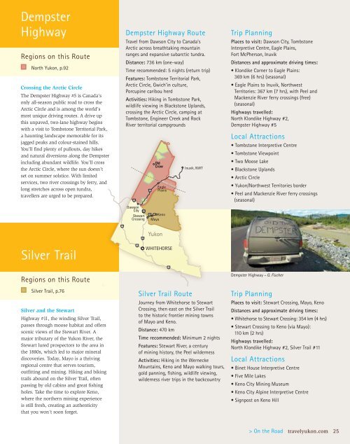
Old<br />
Crow<br />
Eagle<br />
Plains<br />
Dawson<br />
City<br />
Stewart Keno<br />
Crossing Mayo<br />
<strong>Yukon</strong><br />
Arctic Arctic Circle Circle<br />
WHITEHORSE<br />
Inuvik, NWT<br />
Silver Trail Route<br />
Journey from Whitehorse to Stewart<br />
Crossing, then east on the Silver Trail<br />
to the historic frontier mining towns<br />
of Mayo and Keno.<br />
Distance: 470 km<br />
Time recommended: Minimum 2 nights<br />
Features: Stewart River, a century<br />
of mining history, the Peel wilderness<br />
Activities: Hiking in the Wernecke<br />
Mountains, Keno and Mayo walking tours,<br />
gold panning, fishing, wildlife viewing,<br />
wilderness river trips in the backcountry<br />
Trip Planning<br />
Places to visit: Dawson City, Tombstone<br />
Interpretive Centre, Eagle Plains,<br />
Fort McPherson, Inuvik<br />
Distances and approximate driving times:<br />
• Klondike Corner to Eagle Plains:<br />
369 km (6 hrs) (seasonal)<br />
• Eagle Plains to Inuvik, Northwest<br />
Territories: 367 km (7 hrs), with Peel and<br />
Mackenzie River ferry crossings (free)<br />
(seasonal)<br />
Highways travelled:<br />
North Klondike Highway #2,<br />
Dempster Highway #5<br />
Local Attractions<br />
• Tombstone Interpretive Centre<br />
• Tombstone Viewpoint<br />
• Two Moose Lake<br />
• Blackstone Uplands<br />
• Arctic Circle<br />
• <strong>Yukon</strong>/Northwest Territories border<br />
• Peel and Mackenzie River ferry crossings<br />
(seasonal)<br />
Dempster Highway – G. Fischer<br />
Trip Planning<br />
Places to visit: Stewart Crossing, Mayo, Keno<br />
Distances and approximate driving times:<br />
• Whitehorse to Stewart Crossing: 354 km (4 hrs)<br />
• Stewart Crossing to Keno (via Mayo):<br />
110 km (2 hrs)<br />
Highways travelled:<br />
North Klondike Highway #2, Silver Trail #11<br />
Local Attractions<br />
• Binet House Interpretive Centre<br />
• Five Mile Lakes<br />
• Keno City Mining Museum<br />
• Keno City Alpine Interpretive Centre<br />
• Signpost on Keno Hill<br />
> On the Road travelyukon.com 25