2013 VACATION PLANNER - Travel Yukon
2013 VACATION PLANNER - Travel Yukon
2013 VACATION PLANNER - Travel Yukon

You also want an ePaper? Increase the reach of your titles
YUMPU automatically turns print PDFs into web optimized ePapers that Google loves.
24<br />
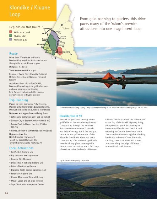
Klondike / Kluane<br />
Loop<br />
Regions on this Route<br />
Whitehorse, p.44<br />
Kluane, p.62<br />
Klondike, p.82<br />
Chicken, AK<br />
Tok, AK<br />
Beaver<br />
Creek<br />
Burwash Landing<br />
Destruction<br />
Bay<br />
Haines<br />
Junction<br />
Route<br />
Drive from Whitehorse to historic<br />
Dawson City, loop into Alaska and return<br />
through the scenic Kluane region.<br />
Distance: 1,435 km<br />
Time recommended: 5 nights<br />
Features: <strong>Yukon</strong> River, Klondike National<br />
Historic Sites, Kluane National Park and<br />
Reserve<br />
Activities: River trip to Fort Selkirk,<br />
Dawson City walking tour, gold mine tours<br />
and gold panning, experiencing<br />
First Nations culture, wildlife viewing,<br />
day adventures in Kluane Country<br />
Trip Planning<br />
Places to visit: Carmacks, Pelly Crossing,<br />
Dawson City, Beaver Creek, Burwash Landing,<br />
Destruction Bay, Haines Junction, Whitehorse<br />
Distances and approximate driving times:<br />
• Whitehorse to Dawson City: 535 km (6 hrs)<br />
• Dawson City to Beaver Creek: 446 km (6 hrs)<br />
• Beaver Creek to Haines Junction: 298 km<br />
(3.5 hrs)<br />
• Haines Junction to Whitehorse: 158 km (2 hrs)<br />
Highways travelled:<br />
North Klondike Highway #2,<br />
Top of the World Highway #9,<br />
Taylor Highway, Alaska Highway #1<br />
Local Attractions<br />
• Fort Selkirk Historic Site<br />
• Big Jonathan Heritage Centre<br />
• Dawson City Museum<br />
• Dredge No. 4 National Historic Site<br />
• Dänojà Zho Cultural Centre<br />
• Diamond Tooth Gerties Gambling Hall<br />
• Forty Mile Historic Site<br />
• Kluane Museum of Natural History<br />
• Mount Logan and St. Elias Icefields<br />
• Tagé Cho Hudän Interpretive Centre<br />
Dawson<br />
City<br />
Stewart<br />
Crossing<br />
Pelly<br />
Crossing<br />
Carmacks<br />
<strong>Yukon</strong><br />
WHITEHORSE<br />
Kluane Lake has boating, fishing, camping and breathtaking vistas, all accessible from the highway – YG, D. Crowe<br />
Klondike Trail of ’98<br />
Embark on your own journey to the<br />
goldfields on the meandering drive to<br />
Dawson City through the Northern<br />
Tutchone communities of Carmacks<br />
and Pelly Crossing. You’ll feel the grit,<br />
heartache and golden dreams of the<br />
Klondike Gold Rush when you reach<br />
Dawson City. This authentic gold rush<br />
town is a lively place bursting with<br />
historic sites, attractions and a full range<br />
of services. After the bustle of Dawson,<br />
Top of the World Highway – G. Fischer<br />
From gold panning to glaciers, this drive<br />
packs many of the <strong>Yukon</strong>’s premier<br />
attractions into one magnificent loop.<br />
take the free ferry across the <strong>Yukon</strong> River<br />
to the Top of the World Highway. Bring<br />
your passport, you’ll be crossing an<br />
international border into the U.S. and<br />
returning to Canada. Loop back to the<br />
<strong>Yukon</strong> and continue through breathtaking<br />
landscape to Beaver Creek, Burwash<br />
Landing, Destruction Bay and Haines<br />
Junction, along the edge of Kluane<br />
National Park and Reserve.