

EuroSDR Projects - Host Ireland
EuroSDR Projects - Host Ireland
EuroSDR Projects - Host Ireland

You also want an ePaper? Increase the reach of your titles
YUMPU automatically turns print PDFs into web optimized ePapers that Google loves.
Table 3 gives an overview over the types of features<br />
used for each class. Depending on the type of land cover<br />
present in an image the class hierarchy has to be adjusted<br />
e.g. to account for water bodies. The parameters were<br />
chosen in such a fashion as to allow an easy adjustment<br />
to data from different sources. Depending on the radiometric<br />
correction performed on the data, no or hardly<br />
any adjustments have to be done to classify images from<br />
one data set. Most classes are defined by parameters<br />
derived from spectral values such as brightness, ratio<br />
and standard deviation. Only fields are also defined by<br />
other features such as area and number of sub-objects.<br />
Streets were not defined as a separate class but are<br />
assigned to whatever urban class the fall into depending<br />
on the type of surface used. In this strictly hierarchical<br />
classification non-urban features such as vegetation and<br />
fields are classified first and if the differentiation were<br />
only to emphasis urban/non urban objects the classification<br />
could be considered finished with the class Not<br />
Fields. However, in order to allow refinement of the<br />
classification, remove unwanted artifacts and allow a<br />
better comparison with the reference data, the urban<br />
classes are differentiated further.<br />
Aim of the analysis is to highlight those areas where<br />
changes are likely to have taken place. Depending on the<br />
number of classes and the spatial aggregation level of the<br />
reference data the number of classes can be very different<br />
compared to those of the classification. For this<br />
reason comparison is carried out on the basis of plausibility<br />
as opposed to creating change/no change map.<br />
Depending on which class is present in the reference<br />
data and which in the classification, a segment is either<br />
assigned to the class identical, plausible, questionable or<br />
new. Identical are those class combination which<br />
indicate that the reference data and the classification<br />
show the same kind of class e.g. reed roof in the classification<br />
and building in the reference data. Plausible are<br />
those combinations that do not directly agree but very<br />
likely do not indicate change e.g. meadow in the classification<br />
and arable land the reference data. The term<br />
questionable refers to doubts whether, based on the<br />
classification, the reference data is correct. An example<br />
is grassland in the classification and road in the reference<br />
data. As grassland can usually be identified very well the<br />
reference data must be put into question. Loss of built up<br />
area falls into this class as well. New are all those<br />
combinations that are an indication of building activities<br />
such as grassland in the reference data and bright object<br />
in the classification.<br />
Results<br />
In the following section the results for the Austrian study<br />
area will be presented. In addition first experimental<br />
results for the other data sets will be discussed. A subset<br />
from one orthophoto was selected to allow a more<br />
detailed analysis although the procedure was applied to<br />
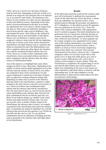
all 15 orthophotos. As described in section III segmentation<br />
was performed on two levels. Fig. 1 shows the<br />
subset of the Austrian orthophotos with segmentation<br />
level 2 overlaid in magenta. The initial classification was<br />
performed on level 2 using fuzzy functions drawing on<br />
features calculated for each segment as defined for each<br />
class within the class hierarchy. As some segments can<br />
be wrongly assigned a new segmentation level, based<br />
only on the existing classification, was created. Using<br />
neighborhood functions unwanted artifacts such as<br />
shadows in forest as well as incorrectly assigned segments<br />
in bare fields were corrected. The corrected<br />
classification for the subset is shown in Fig. 2. Segments<br />
assigned to either red roof (red), bright objects (magenta),<br />
forest or large trees (dark green), grey objects<br />
(cyan), meadow (light green), other urban objects<br />
(yellow), fields (orange) or shadow (black). When the<br />
classification is compared to the original image it can be<br />
seen that all urban features have been assigned to an<br />
urban class. Depending on the type of roof, houses are<br />
either classified as individual objects or blend in with the<br />
surrounding area: As the main emphasis is on the<br />
differentiation of urban and non-urban objects this does<br />
not represent a disadvantage.<br />
Figure 1. Segmentation Level 2<br />
169


